

1 Variability of the Deepwater Horizon Surface Oil Spill Extent …
13
(a)
(b)
(c)
(d)
(e)
(f)
92˚W 90˚W 88˚W 86˚W 84˚W 82˚W 80˚W 78˚W
20˚N
22˚N
24˚N
26˚N
28˚N
30˚N
(g)
(h)
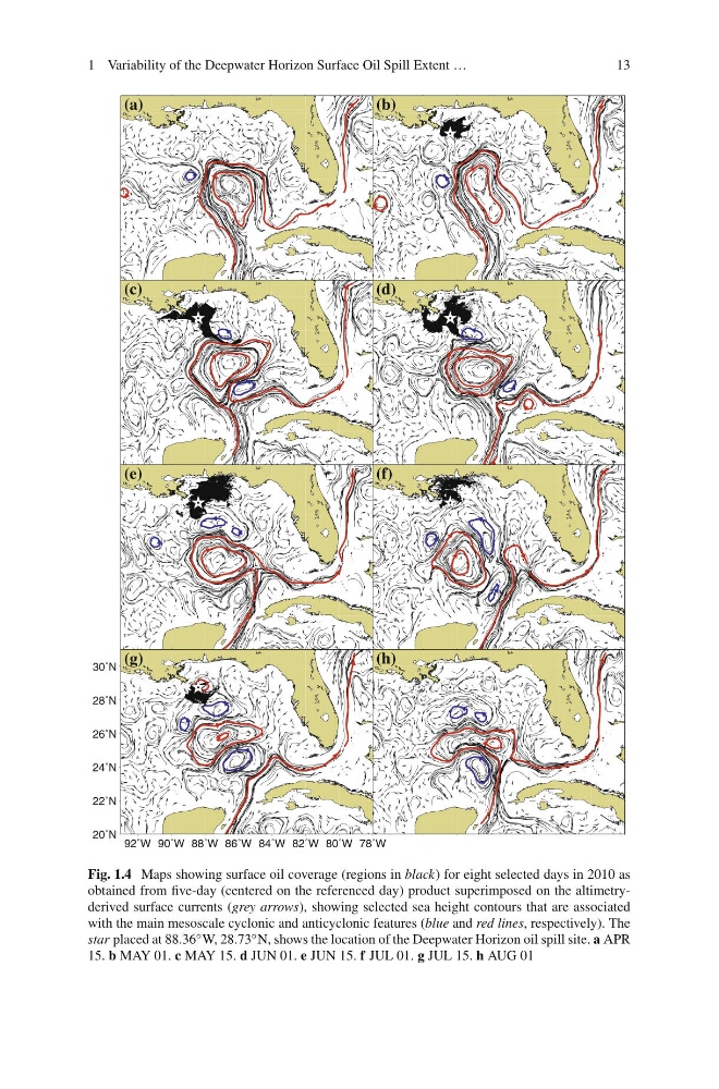
Fig. 1.4 Maps showing surface oil coverage (regions in black) for eight selected days in 2010 as
obtained from five-day (centered on the referenced day) product superimposed on the altimetryderived surface currents (grey arrows), showing selected sea height contours that are associated
with the main mesoscale cyclonic and anticyclonic features (blue and red lines, respectively). The
star placed at 88.36 ◦ W, 28.73 ◦ N, shows the location of the Deepwater Horizon oil spill site. a APR
15. b MAY 01. c MAY 15. d JUN 01. e JUN 15. f JUL 01. g JUL 15. h AUG 01
13
(a)
(b)
(c)
(d)
(e)
(f)
92˚W 90˚W 88˚W 86˚W 84˚W 82˚W 80˚W 78˚W
20˚N
22˚N
24˚N
26˚N
28˚N
30˚N
(g)
(h)
Fig. 1.4 Maps showing surface oil coverage (regions in black) for eight selected days in 2010 as
obtained from five-day (centered on the referenced day) product superimposed on the altimetryderived surface currents (grey arrows), showing selected sea height contours that are associated
with the main mesoscale cyclonic and anticyclonic features (blue and red lines, respectively). The
star placed at 88.36 ◦ W, 28.73 ◦ N, shows the location of the Deepwater Horizon oil spill site. a APR
15. b MAY 01. c MAY 15. d JUN 01. e JUN 15. f JUL 01. g JUL 15. h AUG 01