

The Great Barrier Reef
22
not have as grand or extensive an expression as its
modern interglacial sibling in terms of accumulated organic carbonate features. There are some obvious factors that may ultimately explain this. The first is the sea
floor slope. Worldwide, continental shelves typically
have very shallow gradients from the coast to the shelfslope break where the gradient markedly increases.
Here, a one metre rise in sea level can result in kilometres of shoreline displacement. During times of rapidly
rising sea level, rates of reef growth from 4 m ky
1 to
10 m ky
1 are common and environmental gradients
are shallow, broad and dynamic. This means that on a
shallow continental shelf environmental conditions
have the potential to change very rapidly both in a
‘turn on’ (increased oceanic circulation/reduced shoreline terrigenous influence), and ‘turn off’ (decreasing
circulation, water depth, increasing sedimentation)
mode. By contrast, steeper gradients, seen in the steep
drop-offs on the GBR Ribbon Reefs and in atoll settings,
are more like dipsticks, where the shoreline recedes little during sea level rise and environmental gradients
are steep, narrow and less dynamic.
A further consideration influencing reef development is the effect of sea level when still stand is achieved.
Rivers that flow across the continental shelf during ice
ages have their floodplain sediments remobilised during the next transgression. These materials are moved
inshore by the wave climate and end up, in the eastern
Australian case, coming onshore in spectacular dune
fields. Geological studies of a dune island barrier system enclosing Moreton Bay, southern Queensland,
showed that when sea level rise stops, the onshore
movement of sediments into the near-shore sediment
profile slows and coastal dune building decreases in
(A)
(B)
(C)
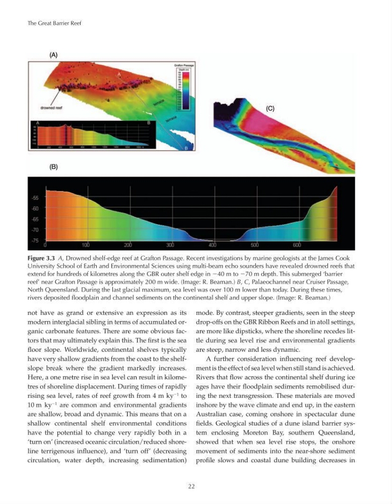
Figure 3.3 A, Drowned shelf-edge reef at Grafton Passage. Recent investigations by marine geologists at the James Cook
University School of Earth and Environmental Sciences using multi-beam echo sounders have revealed drowned reefs that
extend for hundreds of kilometres along the GBR outer shelf edge in 40 m to 70 m depth. This submerged ‘barrier
reef’ near Grafton Passage is approximately 200 m wide. (Image: R. Beaman.) B, C, Palaeochannel near Cruiser Passage,
North Queensland. During the last glacial maximum, sea level was over 100 m lower than today. During these times,
rivers deposited floodplain and channel sediments on the continental shelf and upper slope. (Image: R. Beaman.)
22
not have as grand or extensive an expression as its
modern interglacial sibling in terms of accumulated organic carbonate features. There are some obvious factors that may ultimately explain this. The first is the sea
floor slope. Worldwide, continental shelves typically
have very shallow gradients from the coast to the shelfslope break where the gradient markedly increases.
Here, a one metre rise in sea level can result in kilometres of shoreline displacement. During times of rapidly
rising sea level, rates of reef growth from 4 m ky
1 to
10 m ky
1 are common and environmental gradients
are shallow, broad and dynamic. This means that on a
shallow continental shelf environmental conditions
have the potential to change very rapidly both in a
‘turn on’ (increased oceanic circulation/reduced shoreline terrigenous influence), and ‘turn off’ (decreasing
circulation, water depth, increasing sedimentation)
mode. By contrast, steeper gradients, seen in the steep
drop-offs on the GBR Ribbon Reefs and in atoll settings,
are more like dipsticks, where the shoreline recedes little during sea level rise and environmental gradients
are steep, narrow and less dynamic.
A further consideration influencing reef development is the effect of sea level when still stand is achieved.
Rivers that flow across the continental shelf during ice
ages have their floodplain sediments remobilised during the next transgression. These materials are moved
inshore by the wave climate and end up, in the eastern
Australian case, coming onshore in spectacular dune
fields. Geological studies of a dune island barrier system enclosing Moreton Bay, southern Queensland,
showed that when sea level rise stops, the onshore
movement of sediments into the near-shore sediment
profile slows and coastal dune building decreases in
(A)
(B)
(C)
Figure 3.3 A, Drowned shelf-edge reef at Grafton Passage. Recent investigations by marine geologists at the James Cook
University School of Earth and Environmental Sciences using multi-beam echo sounders have revealed drowned reefs that
extend for hundreds of kilometres along the GBR outer shelf edge in 40 m to 70 m depth. This submerged ‘barrier
reef’ near Grafton Passage is approximately 200 m wide. (Image: R. Beaman.) B, C, Palaeochannel near Cruiser Passage,
North Queensland. During the last glacial maximum, sea level was over 100 m lower than today. During these times,
rivers deposited floodplain and channel sediments on the continental shelf and upper slope. (Image: R. Beaman.)