

The Great Barrier Reef
112
will be integrated through a set of catchment to reef
models.
However, terrestrial pollution is not the only stress
facing the ecosystems of the GBR, and it is the combination of multiple stresses (from global climate change,
fishing and pollution principally) that will escalate
threats to the long term viability of the system. Management of water quality issues alone, no matter how
effective, are unlikely to prevent further degradation
of the GBRWHA without concurrent management of
fishing impacts and climate change.
(A)
(B)
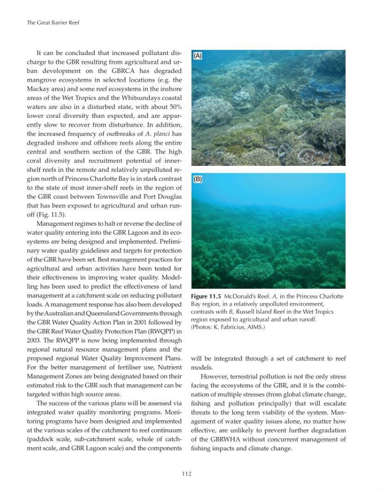
Figure 11.5 McDonald’s Reef. A, in the Princess Charlotte
Bay region, in a relatively unpolluted environment,
contrasts with B, Russell Island Reef in the Wet Tropics
region exposed to agricultural and urban runoff.
(Photos: K. Fabricius, AIMS.)
It can be concluded that increased pollutant discharge to the GBR resulting from agricultural and urban development on the GBRCA has degraded
mangrove ecosystems in selected locations (e.g. the
Mackay area) and some reef ecosystems in the inshore
areas of the Wet Tropics and the Whitsundays coastal
waters are also in a disturbed state, with about 50%
lower coral diversity than expected, and are apparently slow to recover from disturbance. In addition,
the increased frequency of outbreaks of A. planci has
degraded inshore and offshore reefs along the entire
central and southern section of the GBR. The high
coral diversity and recruitment potential of innershelf reefs in the remote and relatively unpolluted region north of Princess Charlotte Bay is in stark contrast
to the state of most inner-shelf reefs in the region of
the GBR coast between Townsville and Port Douglas
that has been exposed to agricultural and urban runoff (Fig. 11.5).
Management regimes to halt or reverse the decline of
water quality entering into the GBR Lagoon and its ecosystems are being designed and implemented. Preliminary water quality guidelines and targets for protection
of the GBR have been set. Best management practices for
agricultural and urban activities have been tested for
their effectiveness in improving water quality. Modelling has been used to predict the effectiveness of land
management at a catchment scale on reducing pollutant
loads. A management response has also been developed
by the Australian and Queensland Governments through
the GBR Water Quality Action Plan in 2001 followed by
the GBR Reef Water Quality Protection Plan (RWQPP) in
2003. The RWQPP is now being implemented through
regional natural resource management plans and the
proposed regional Water Quality Improvement Plans.
For the better management of fertiliser use, Nutrient
Management Zones are being designated based on their
estimated risk to the GBR such that management can be
targeted within high source areas.
The success of the various plans will be assessed via
integrated water quality monitoring programs. Monitoring programs have been designed and implemented
at the various scales of the catchment to reef continuum
(paddock scale, sub-catchment scale, whole of catchment scale, and GBR Lagoon scale) and the components
112
will be integrated through a set of catchment to reef
models.
However, terrestrial pollution is not the only stress
facing the ecosystems of the GBR, and it is the combination of multiple stresses (from global climate change,
fishing and pollution principally) that will escalate
threats to the long term viability of the system. Management of water quality issues alone, no matter how
effective, are unlikely to prevent further degradation
of the GBRWHA without concurrent management of
fishing impacts and climate change.
(A)
(B)
Figure 11.5 McDonald’s Reef. A, in the Princess Charlotte
Bay region, in a relatively unpolluted environment,
contrasts with B, Russell Island Reef in the Wet Tropics
region exposed to agricultural and urban runoff.
(Photos: K. Fabricius, AIMS.)
It can be concluded that increased pollutant discharge to the GBR resulting from agricultural and urban development on the GBRCA has degraded
mangrove ecosystems in selected locations (e.g. the
Mackay area) and some reef ecosystems in the inshore
areas of the Wet Tropics and the Whitsundays coastal
waters are also in a disturbed state, with about 50%
lower coral diversity than expected, and are apparently slow to recover from disturbance. In addition,
the increased frequency of outbreaks of A. planci has
degraded inshore and offshore reefs along the entire
central and southern section of the GBR. The high
coral diversity and recruitment potential of innershelf reefs in the remote and relatively unpolluted region north of Princess Charlotte Bay is in stark contrast
to the state of most inner-shelf reefs in the region of
the GBR coast between Townsville and Port Douglas
that has been exposed to agricultural and urban runoff (Fig. 11.5).
Management regimes to halt or reverse the decline of
water quality entering into the GBR Lagoon and its ecosystems are being designed and implemented. Preliminary water quality guidelines and targets for protection
of the GBR have been set. Best management practices for
agricultural and urban activities have been tested for
their effectiveness in improving water quality. Modelling has been used to predict the effectiveness of land
management at a catchment scale on reducing pollutant
loads. A management response has also been developed
by the Australian and Queensland Governments through
the GBR Water Quality Action Plan in 2001 followed by
the GBR Reef Water Quality Protection Plan (RWQPP) in
2003. The RWQPP is now being implemented through
regional natural resource management plans and the
proposed regional Water Quality Improvement Plans.
For the better management of fertiliser use, Nutrient
Management Zones are being designated based on their
estimated risk to the GBR such that management can be
targeted within high source areas.
The success of the various plans will be assessed via
integrated water quality monitoring programs. Monitoring programs have been designed and implemented
at the various scales of the catchment to reef continuum
(paddock scale, sub-catchment scale, whole of catchment scale, and GBR Lagoon scale) and the components