

the Norman Conquest (eleventh Century) for the coastal Levels, with the Moors
enclosed and drained with fields, ditches, rhynes and engineered rivers between
1750 and 1850 (Clout 2014; Natural England 2013). This landscape has become
one of the UK’s most significant (peat) wetland natural environments, and has
emerged as a result of a complex management history characterised by the coexistence of agriculture and water/environmental management (Natural England
2014). This history has created an interesting heritage of farming, wetland and
natural wildlife within the landscape and 13 % of this area is now recognised as a
Site of Special Scientific Interest, a Special Protection Area and an internationally
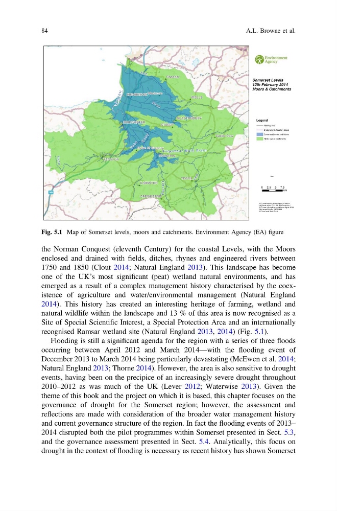
recognised Ramsar wetland site (Natural England 2013, 2014) (Fig. 5.1).
Flooding is still a significant agenda for the region with a series of three floods
occurring between April 2012 and March 2014—with the flooding event of
December 2013 to March 2014 being particularly devastating (McEwen et al. 2014;
Natural England 2013; Thorne 2014). However, the area is also sensitive to drought
events, having been on the precipice of an increasingly severe drought throughout
2010–2012 as was much of the UK (Lever 2012; Waterwise 2013). Given the
theme of this book and the project on which it is based, this chapter focuses on the
governance of drought for the Somerset region; however, the assessment and
reflections are made with consideration of the broader water management history
and current governance structure of the region. In fact the flooding events of 2013–
2014 disrupted both the pilot programmes within Somerset presented in Sect. 5.3,
and the governance assessment presented in Sect. 5.4. Analytically, this focus on
drought in the context of flooding is necessary as recent history has shown Somerset
P a r r e t t
P a r r e t t
A x e
A x e
S o w
y
S o w
y
B r u e
B r u e
T o
n
e
T o
n
e
Y e o
Y e o
t
t
e
r
r
a
P
t
t
e
r
r
a
P
To
n
e
To
n
e
K i n g s m o o r M a i n D r a i n
K i n g s m o o r M a i n D r a i n
M5
WELLS
YEOVIL
STREET
Cheddar
Wedmore
TAUNTON
CREWKERNE
ILMINSTER
HIGHBRIDGE
Castle Cary
GLASTONBURY
Muchelney
BRIDGWATER
Stoke St Gregory
Somerset Levels
12th February 2014
Moors & Catchments
© Environment Agency copyright and/or
database rights 2014. All rights reserved.
© Crown copyright and database rights 2014
Ordnance Survey 100024198
© Canal and River Trust
Legend
Railway line
Bridgwater & Taunton Canal
Somerset Levels and Moors
Hydrological catchments
¯
0 2.5 5 7.5
km
Fig. 5.1 Map of Somerset levels, moors and catchments. Environment Agency (EA) figure
84
A.L. Browne et al.
enclosed and drained with fields, ditches, rhynes and engineered rivers between
1750 and 1850 (Clout 2014; Natural England 2013). This landscape has become
one of the UK’s most significant (peat) wetland natural environments, and has
emerged as a result of a complex management history characterised by the coexistence of agriculture and water/environmental management (Natural England
2014). This history has created an interesting heritage of farming, wetland and
natural wildlife within the landscape and 13 % of this area is now recognised as a
Site of Special Scientific Interest, a Special Protection Area and an internationally
recognised Ramsar wetland site (Natural England 2013, 2014) (Fig. 5.1).
Flooding is still a significant agenda for the region with a series of three floods
occurring between April 2012 and March 2014—with the flooding event of
December 2013 to March 2014 being particularly devastating (McEwen et al. 2014;
Natural England 2013; Thorne 2014). However, the area is also sensitive to drought
events, having been on the precipice of an increasingly severe drought throughout
2010–2012 as was much of the UK (Lever 2012; Waterwise 2013). Given the
theme of this book and the project on which it is based, this chapter focuses on the
governance of drought for the Somerset region; however, the assessment and
reflections are made with consideration of the broader water management history
and current governance structure of the region. In fact the flooding events of 2013–
2014 disrupted both the pilot programmes within Somerset presented in Sect. 5.3,
and the governance assessment presented in Sect. 5.4. Analytically, this focus on
drought in the context of flooding is necessary as recent history has shown Somerset
P a r r e t t
P a r r e t t
A x e
A x e
S o w
y
S o w
y
B r u e
B r u e
T o
n
e
T o
n
e
Y e o
Y e o
t
t
e
r
r
a
P
t
t
e
r
r
a
P
To
n
e
To
n
e
K i n g s m o o r M a i n D r a i n
K i n g s m o o r M a i n D r a i n
M5
WELLS
YEOVIL
STREET
Cheddar
Wedmore
TAUNTON
CREWKERNE
ILMINSTER
HIGHBRIDGE
Castle Cary
GLASTONBURY
Muchelney
BRIDGWATER
Stoke St Gregory
Somerset Levels
12th February 2014
Moors & Catchments
© Environment Agency copyright and/or
database rights 2014. All rights reserved.
© Crown copyright and database rights 2014
Ordnance Survey 100024198
© Canal and River Trust
Legend
Railway line
Bridgwater & Taunton Canal
Somerset Levels and Moors
Hydrological catchments
¯
0 2.5 5 7.5
km
Fig. 5.1 Map of Somerset levels, moors and catchments. Environment Agency (EA) figure
84
A.L. Browne et al.