

criteria (extent, coherence, flexibility and intensity). The methodology is described
in detail in Chap. 3.
The chapter presents the context of water management in Flanders, describes
some measures which are already implemented related to drought management,
explains the results of our analysis in terms of the Governance Assessment Toolkit
and presents our possible conclusions and recommendations for improved drought
governance.
According to the definition of the Water Framework Directive (WFD), the
Belgian territory belongs to four international river basin districts (RBDs) which are
shared with other member states and/or third countries. The RBDs of Meuse and
Scheldt cover most of the Belgian territory, whereas the Rhine and Seine river
basins cover much smaller parts in the south of Belgium.
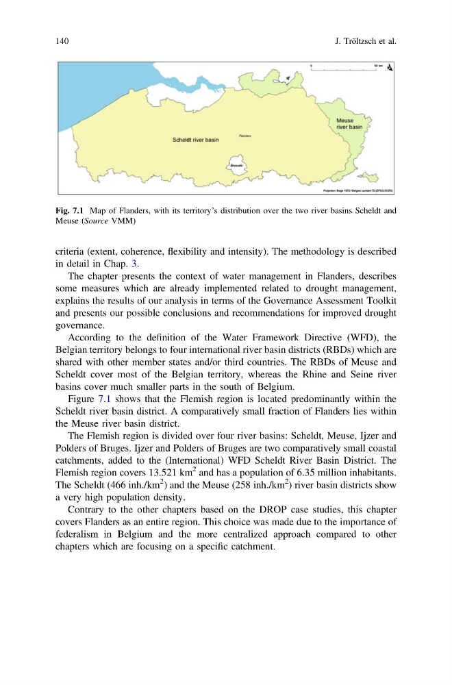
Figure 7.1 shows that the Flemish region is located predominantly within the
Scheldt river basin district. A comparatively small fraction of Flanders lies within
the Meuse river basin district.
The Flemish region is divided over four river basins: Scheldt, Meuse, Ijzer and
Polders of Bruges. Ijzer and Polders of Bruges are two comparatively small coastal
catchments, added to the (International) WFD Scheldt River Basin District. The
Flemish region covers 13.521 km
2 and has a population of 6.35 million inhabitants.
The Scheldt (466 inh./km
2 ) and the Meuse (258 inh./km
2 ) river basin districts show
a very high population density.
Contrary to the other chapters based on the DROP case studies, this chapter
covers Flanders as an entire region. This choice was made due to the importance of
federalism in Belgium and the more centralized approach compared to other
chapters which are focusing on a specific catchment.
Fig. 7.1 Map of Flanders, with its territory’s distribution over the two river basins Scheldt and
Meuse (Source VMM)
140
J. Tröltzsch et al.
in detail in Chap. 3.
The chapter presents the context of water management in Flanders, describes
some measures which are already implemented related to drought management,
explains the results of our analysis in terms of the Governance Assessment Toolkit
and presents our possible conclusions and recommendations for improved drought
governance.
According to the definition of the Water Framework Directive (WFD), the
Belgian territory belongs to four international river basin districts (RBDs) which are
shared with other member states and/or third countries. The RBDs of Meuse and
Scheldt cover most of the Belgian territory, whereas the Rhine and Seine river
basins cover much smaller parts in the south of Belgium.
Figure 7.1 shows that the Flemish region is located predominantly within the
Scheldt river basin district. A comparatively small fraction of Flanders lies within
the Meuse river basin district.
The Flemish region is divided over four river basins: Scheldt, Meuse, Ijzer and
Polders of Bruges. Ijzer and Polders of Bruges are two comparatively small coastal
catchments, added to the (International) WFD Scheldt River Basin District. The
Flemish region covers 13.521 km
2 and has a population of 6.35 million inhabitants.
The Scheldt (466 inh./km
2 ) and the Meuse (258 inh./km
2 ) river basin districts show
a very high population density.
Contrary to the other chapters based on the DROP case studies, this chapter
covers Flanders as an entire region. This choice was made due to the importance of
federalism in Belgium and the more centralized approach compared to other
chapters which are focusing on a specific catchment.
Fig. 7.1 Map of Flanders, with its territory’s distribution over the two river basins Scheldt and
Meuse (Source VMM)
140
J. Tröltzsch et al.