

Regional responsibility for climate change adaptation lies within the Regional
Scheme for Climate, Air and Energy (SRCAE) and the Climate-Energy Plans
(PCET), which are currently being developed at the local level (i.e. for municipalities with 50,000 inhabitants or more).
6.3 Geo-Hydro Context, Drought Policy Focus
and Measures Taken in the Vilaine
6.3.1 The Vilaine River
6.3.1.1 Hydrological Description
The Vilaine River is a river nearly 230 km long flowing into the Atlantic Ocean. Its
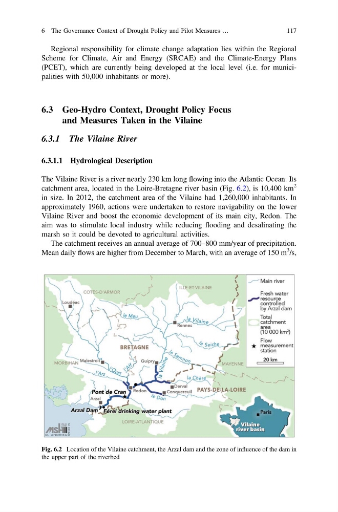
catchment area, located in the Loire-Bretagne river basin (Fig. 6.2), is 10,400 km
2
in size. In 2012, the catchment area of the Vilaine had 1,260,000 inhabitants. In
approximately 1960, actions were undertaken to restore navigability on the lower
Vilaine River and boost the economic development of its main city, Redon. The
aim was to stimulate local industry while reducing flooding and desalinating the
marsh so it could be devoted to agricultural activities.
The catchment receives an annual average of 700–800 mm/year of precipitation.
Mean daily flows are higher from December to March, with an average of 150 m
3 /s,
Fig. 6.2 Location of the Vilaine catchment, the Arzal dam and the zone of influence of the dam in
the upper part of the riverbed
6 The Governance Context of Drought Policy and Pilot Measures …
117
Scheme for Climate, Air and Energy (SRCAE) and the Climate-Energy Plans
(PCET), which are currently being developed at the local level (i.e. for municipalities with 50,000 inhabitants or more).
6.3 Geo-Hydro Context, Drought Policy Focus
and Measures Taken in the Vilaine
6.3.1 The Vilaine River
6.3.1.1 Hydrological Description
The Vilaine River is a river nearly 230 km long flowing into the Atlantic Ocean. Its
catchment area, located in the Loire-Bretagne river basin (Fig. 6.2), is 10,400 km
2
in size. In 2012, the catchment area of the Vilaine had 1,260,000 inhabitants. In
approximately 1960, actions were undertaken to restore navigability on the lower
Vilaine River and boost the economic development of its main city, Redon. The
aim was to stimulate local industry while reducing flooding and desalinating the
marsh so it could be devoted to agricultural activities.
The catchment receives an annual average of 700–800 mm/year of precipitation.
Mean daily flows are higher from December to March, with an average of 150 m
3 /s,
Fig. 6.2 Location of the Vilaine catchment, the Arzal dam and the zone of influence of the dam in
the upper part of the riverbed
6 The Governance Context of Drought Policy and Pilot Measures …
117