

140
It also needs to be noted that irrigated lands in Kyrgyzstan provinces have not
been strongly affected by the defi cit of drainage (Dukhovny et al. 2014 ). For example, the irrigated lands of Kyrgyzstan within the valley are characterised as in good
condition (90–96 % of the irrigated lands) in terms of land reclamation, while irrigated lands in Uzbek and Tajik parts of the valley are relatively poor owing to shallow GWL with higher mineralisation and varying levels of soil salinity.
The design parameters (e.g. cross section, slopes, bottom width) in most of the
open drainage systems were altered, and a discharge capacity was reduced due to
over siltation and eutrophication. This is mainly connected with ageing of the CDN
since it was constructed more than 40 years ago on the one hand and low effectiveness of the drainage systems that have decreased to half capacity due to lack of
investments in operation and maintenance on the other. To maintain the system in an
effective manner, it is necessary to carry out regular and comprehensive technical
maintenance (including observation and minor, major and emergency repairs, etc.).
Periodicity of these works was set up during Soviet period and is still carried out.
However, to cope with land restructuring and changes in cropping patterns, these
regulations need to be reviewed and renewed.
10.3.4 Management Structures
The Fergana province has been chosen to describe the water management structures in the valley due to its hierarchy level being similar to the other provinces
(Dukhovny et al. 2009 ).
The water requirement for irrigation is based on cropping patterns and scheduled by the centrally controlled state water management organisations (WMO)
in 10-day intervals. Within the irrigation system, the cropping acreage planned
for the forthcoming growing season thus needs to be submitted to water user
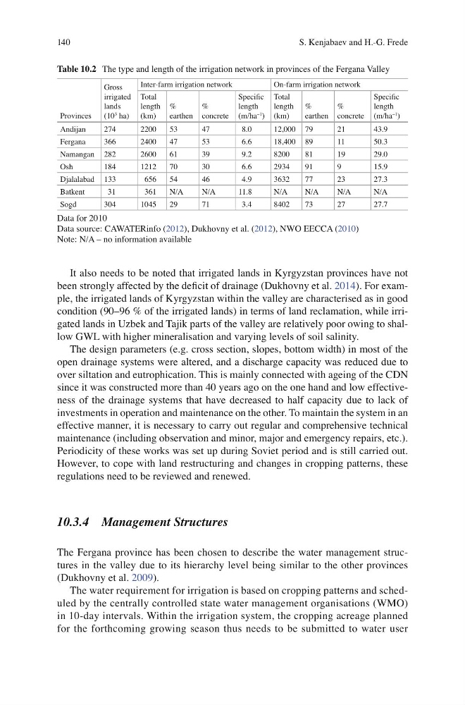
Table 10.2 The type and length of the irrigation network in provinces of the Fergana Valley
Provinces
Gross
irrigated
lands
(10
3 ha)
Inter-farm irrigation network
On-farm irrigation network
Total
length
(km)
%
earthen
%
concrete
Specifi c
length
(m/ha
−1 )
Total
length
(km)
%
earthen
%
concrete
Specifi c
length
(m/ha
−1
)
Andijan
274
2200
53
47
8.0
12,000 79
21
43.9
Fergana
366
2400
47
53
6.6
18,400 89
11
50.3
Namangan 282
2600
61
39
9.2
8200
81
19
29.0
Osh
184
1212
70
30
6.6
2934
91
9
15.9
Djalalabad 133
656
54
46
4.9
3632
77
23
27.3
Batkent
31
361
N/A
N/A
11.8
N/A
N/A
N/A
N/A
Sogd
304
1045
29
71
3.4
8402
73
27
27.7
Data for 2010
Data source: CAWATERinfo ( 2012 ), Dukhovny et al. ( 2012 ), NWO EECCA ( 2010 )
Note: N/A – no information available
S. Kenjabaev and H.-G. Frede
It also needs to be noted that irrigated lands in Kyrgyzstan provinces have not
been strongly affected by the defi cit of drainage (Dukhovny et al. 2014 ). For example, the irrigated lands of Kyrgyzstan within the valley are characterised as in good
condition (90–96 % of the irrigated lands) in terms of land reclamation, while irrigated lands in Uzbek and Tajik parts of the valley are relatively poor owing to shallow GWL with higher mineralisation and varying levels of soil salinity.
The design parameters (e.g. cross section, slopes, bottom width) in most of the
open drainage systems were altered, and a discharge capacity was reduced due to
over siltation and eutrophication. This is mainly connected with ageing of the CDN
since it was constructed more than 40 years ago on the one hand and low effectiveness of the drainage systems that have decreased to half capacity due to lack of
investments in operation and maintenance on the other. To maintain the system in an
effective manner, it is necessary to carry out regular and comprehensive technical
maintenance (including observation and minor, major and emergency repairs, etc.).
Periodicity of these works was set up during Soviet period and is still carried out.
However, to cope with land restructuring and changes in cropping patterns, these
regulations need to be reviewed and renewed.
10.3.4 Management Structures
The Fergana province has been chosen to describe the water management structures in the valley due to its hierarchy level being similar to the other provinces
(Dukhovny et al. 2009 ).
The water requirement for irrigation is based on cropping patterns and scheduled by the centrally controlled state water management organisations (WMO)
in 10-day intervals. Within the irrigation system, the cropping acreage planned
for the forthcoming growing season thus needs to be submitted to water user
Table 10.2 The type and length of the irrigation network in provinces of the Fergana Valley
Provinces
Gross
irrigated
lands
(10
3 ha)
Inter-farm irrigation network
On-farm irrigation network
Total
length
(km)
%
earthen
%
concrete
Specifi c
length
(m/ha
−1 )
Total
length
(km)
%
earthen
%
concrete
Specifi c
length
(m/ha
−1
)
Andijan
274
2200
53
47
8.0
12,000 79
21
43.9
Fergana
366
2400
47
53
6.6
18,400 89
11
50.3
Namangan 282
2600
61
39
9.2
8200
81
19
29.0
Osh
184
1212
70
30
6.6
2934
91
9
15.9
Djalalabad 133
656
54
46
4.9
3632
77
23
27.3
Batkent
31
361
N/A
N/A
11.8
N/A
N/A
N/A
N/A
Sogd
304
1045
29
71
3.4
8402
73
27
27.7
Data for 2010
Data source: CAWATERinfo ( 2012 ), Dukhovny et al. ( 2012 ), NWO EECCA ( 2010 )
Note: N/A – no information available
S. Kenjabaev and H.-G. Frede