

the same habitat covers just around 7 % of the total area and will (L 5, L 10 and L
15 cm) lose more than a half of its recent land cover in the predicted scenarios. In
the worst case scenario, the habitat will gain some space and will represent 0.23 %
more area than today. The overall reduction of coastal habitats was already
described as “coastal squeeze” in Australia (Bayliss et al. 1997) – obstacles,
roads or settlement prevent the landward migration of some ecosystems such as
salt marshes.
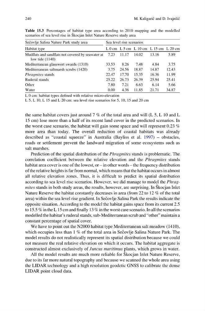
Prediction of the spatial distribution of the Phragmites stands is problematic. The
correlation coefficient between the relative elevation and the Phragmites stands
habitat area cover is one of the lowest, or – in other words – the frequency distribution
of the relative heights is far from normal, which means that the habitat occurs in almost
all relative elevation zones. Thus, it is difficult to predict its spatial distribution
according to sea level rise scenarios. However, we did manage to model the Phragmites stands in both study areas, the results, however, are surprising. In S ˇ kocjan Inlet
Nature Reserve the habitat constantly decreases in area (from 22 to 12 % of the total
area) within the sea level rise gradient. In Sec ˇovlje Salina Park the results indicate the
opposite situation. According to the model the habitat gains space from its current 2.5
to 15.5 % in the L 15 cm and finally 13 % in the worst case scenario. In all the scenarios
modelled the habitat’s ruderal stands, sub-Mediterranean scrub and “other” maintain a
constant percentage of spatial cover.
We have to point out the N2000 habitat type Mediterranean salt meadow (1410),
which occupies less than 1 % of the total area in Sec ˇovlje Salina Nature Park. The
model results do not realistically represent its spatial distribution because we could
not measure the real relative elevation on which it occurs. The habitat aggregate is
constructed almost exclusively of Juncus maritimus plants, which grows in water.
All the model results are much more reliable for S ˇ kocjan Inlet Nature Reserve,
due to its far more natural topography and because we scanned the whole area using
the LIDAR technology and a high resolution geodetic GNSS to calibrate the dense
LIDAR point cloud data.
Table 15.3 Percentages of habitat type area according to 2010 mapping and the modelled
scenarios of sea level rise in S ˇ kocjan Inlet Nature Reserve study area
Sec ˇovlje Salina Nature Park study area
Sea level rise scenarios
Habitat type
L 0 cm L 5 cm L 10 cm L 15 cm L 20 cm
Mudflats and sandflats not covered by seawater at
low tide (1140)
7.23 11.17 14.02
13.16
5.89
Mediterranean glasswort swards (1310)
33.53
8.26
7.48
4.84
3.75
Mediterranean saltmarsh scrubs (1420)
3.75 24.56 18.87
14.87
12.43
Phragmites stands
22.47 17.70 15.35
16.36
11.99
Ruderal stands
25.22 26.73 26.39
25.94
25.41
Other
7.80
7.21
6.63
6.14
5.66
Water
0.00
4.36 11.85
21.71
34.87
L 0 cm: habitat types defined with relative micro-elevation
L 5, L 10, L 15 and L 20 cm: sea level rise scenarios for 5, 10, 15 and 20 cm
240
M. Kaligaric ˇ and D. Ivajns ˇic ˇ
15 cm) lose more than a half of its recent land cover in the predicted scenarios. In
the worst case scenario, the habitat will gain some space and will represent 0.23 %
more area than today. The overall reduction of coastal habitats was already
described as “coastal squeeze” in Australia (Bayliss et al. 1997) – obstacles,
roads or settlement prevent the landward migration of some ecosystems such as
salt marshes.
Prediction of the spatial distribution of the Phragmites stands is problematic. The
correlation coefficient between the relative elevation and the Phragmites stands
habitat area cover is one of the lowest, or – in other words – the frequency distribution
of the relative heights is far from normal, which means that the habitat occurs in almost
all relative elevation zones. Thus, it is difficult to predict its spatial distribution
according to sea level rise scenarios. However, we did manage to model the Phragmites stands in both study areas, the results, however, are surprising. In S ˇ kocjan Inlet
Nature Reserve the habitat constantly decreases in area (from 22 to 12 % of the total
area) within the sea level rise gradient. In Sec ˇovlje Salina Park the results indicate the
opposite situation. According to the model the habitat gains space from its current 2.5
to 15.5 % in the L 15 cm and finally 13 % in the worst case scenario. In all the scenarios
modelled the habitat’s ruderal stands, sub-Mediterranean scrub and “other” maintain a
constant percentage of spatial cover.
We have to point out the N2000 habitat type Mediterranean salt meadow (1410),
which occupies less than 1 % of the total area in Sec ˇovlje Salina Nature Park. The
model results do not realistically represent its spatial distribution because we could
not measure the real relative elevation on which it occurs. The habitat aggregate is
constructed almost exclusively of Juncus maritimus plants, which grows in water.
All the model results are much more reliable for S ˇ kocjan Inlet Nature Reserve,
due to its far more natural topography and because we scanned the whole area using
the LIDAR technology and a high resolution geodetic GNSS to calibrate the dense
LIDAR point cloud data.
Table 15.3 Percentages of habitat type area according to 2010 mapping and the modelled
scenarios of sea level rise in S ˇ kocjan Inlet Nature Reserve study area
Sec ˇovlje Salina Nature Park study area
Sea level rise scenarios
Habitat type
L 0 cm L 5 cm L 10 cm L 15 cm L 20 cm
Mudflats and sandflats not covered by seawater at
low tide (1140)
7.23 11.17 14.02
13.16
5.89
Mediterranean glasswort swards (1310)
33.53
8.26
7.48
4.84
3.75
Mediterranean saltmarsh scrubs (1420)
3.75 24.56 18.87
14.87
12.43
Phragmites stands
22.47 17.70 15.35
16.36
11.99
Ruderal stands
25.22 26.73 26.39
25.94
25.41
Other
7.80
7.21
6.63
6.14
5.66
Water
0.00
4.36 11.85
21.71
34.87
L 0 cm: habitat types defined with relative micro-elevation
L 5, L 10, L 15 and L 20 cm: sea level rise scenarios for 5, 10, 15 and 20 cm
240
M. Kaligaric ˇ and D. Ivajns ˇic ˇ