

Acknowledgements We acknowledge the DLR for the delivery of RapidEye images as part of
the RapidEye Science Archive – proposal 439. The TU Berlin thanks Ruth Sonnenschein and
Moritz Ha ¨rlin for their help and fruitful discussions and Steve Kass for working on HABITCHANGE project outputs 4.1.1, 4.3.7, and 4.3.9 that provided part of the basis for the descriptions
in this chapter.
Open Access This chapter is distributed under the terms of the Creative Commons Attribution
Noncommercial License, which permits any noncommercial use, distribution, and reproduction in
any medium, provided the original author(s) and source are credited.
References
Auer, I., et al. (2007). HISTALP – historical instrumental climatological surface time series of the
Greater Alpine Region. International Journal of Climatology, 27(1), 17–46. doi:10.1002/joc.
1377.
Barnsley, M. J., & Barr, S. L. (1996). Inferring urban land use from satellite sensor images using
kernel-based spatial reclassification. Photogrammetric Engineering & Remote Sensing, 62(8),
949–958.
Berger, M., Moreno, J., Johannessen, J. A., Levelt, P. F., & Hanssen, R. F. (2012). ESA’s sentinel
missions in support of Earth system science. Remote Sensing of Environment, 120, 84–90.
Bock, M., Xofis, P., Mitchley, J., Rossner, G., & Wissen, M. (2005). Object-oriented methods for
habitat mapping at multiple scales – case studies from Northern Germany and Wye Downs,
UK. Journal for Nature Conservation, 13, 75–89.
Burkhardt, R., Robisch, F., & Schro ¨der, E. (2004). Umsetzung der FFH-Richtlinie im Wald –
Gemeinsame bundesweite Empfehlungen der La ¨nderarbeitsgemeinschaft Naturschutz
(LANA) und der Forstchefkonferenz (FCK). Natur und Landschaft, 79, 316–323.
Canty, M. J., & Nielsen, A. A. (2008). Automatic radiometric normalization of multitemporal
satellite imagery with the iteratively re-weighted MAD transformation. Remote Sensing of
Environment, 112, 1025–1036.
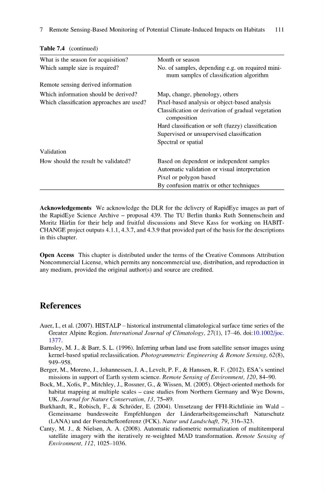
Table 7.4 (continued)
What is the season for acquisition?
Month or season
Which sample size is required?
No. of samples, depending e.g. on required minimum samples of classification algorithm
Remote sensing derived information
Which information should be derived?
Map, change, phenology, others
Which classification approaches are used?
Pixel-based analysis or object-based analysis
Classification or derivation of gradual vegetation
composition
Hard classification or soft (fuzzy) classification
Supervised or unsupervised classification
Spectral or spatial
Validation
How should the result be validated?
Based on dependent or independent samples
Automatic validation or visual interpretation
Pixel or polygon based
By confusion matrix or other techniques
7 Remote Sensing-Based Monitoring of Potential Climate-Induced Impacts on Habitats
111
the RapidEye Science Archive – proposal 439. The TU Berlin thanks Ruth Sonnenschein and
Moritz Ha ¨rlin for their help and fruitful discussions and Steve Kass for working on HABITCHANGE project outputs 4.1.1, 4.3.7, and 4.3.9 that provided part of the basis for the descriptions
in this chapter.
Open Access This chapter is distributed under the terms of the Creative Commons Attribution
Noncommercial License, which permits any noncommercial use, distribution, and reproduction in
any medium, provided the original author(s) and source are credited.
References
Auer, I., et al. (2007). HISTALP – historical instrumental climatological surface time series of the
Greater Alpine Region. International Journal of Climatology, 27(1), 17–46. doi:10.1002/joc.
1377.
Barnsley, M. J., & Barr, S. L. (1996). Inferring urban land use from satellite sensor images using
kernel-based spatial reclassification. Photogrammetric Engineering & Remote Sensing, 62(8),
949–958.
Berger, M., Moreno, J., Johannessen, J. A., Levelt, P. F., & Hanssen, R. F. (2012). ESA’s sentinel
missions in support of Earth system science. Remote Sensing of Environment, 120, 84–90.
Bock, M., Xofis, P., Mitchley, J., Rossner, G., & Wissen, M. (2005). Object-oriented methods for
habitat mapping at multiple scales – case studies from Northern Germany and Wye Downs,
UK. Journal for Nature Conservation, 13, 75–89.
Burkhardt, R., Robisch, F., & Schro ¨der, E. (2004). Umsetzung der FFH-Richtlinie im Wald –
Gemeinsame bundesweite Empfehlungen der La ¨nderarbeitsgemeinschaft Naturschutz
(LANA) und der Forstchefkonferenz (FCK). Natur und Landschaft, 79, 316–323.
Canty, M. J., & Nielsen, A. A. (2008). Automatic radiometric normalization of multitemporal
satellite imagery with the iteratively re-weighted MAD transformation. Remote Sensing of
Environment, 112, 1025–1036.
Table 7.4 (continued)
What is the season for acquisition?
Month or season
Which sample size is required?
No. of samples, depending e.g. on required minimum samples of classification algorithm
Remote sensing derived information
Which information should be derived?
Map, change, phenology, others
Which classification approaches are used?
Pixel-based analysis or object-based analysis
Classification or derivation of gradual vegetation
composition
Hard classification or soft (fuzzy) classification
Supervised or unsupervised classification
Spectral or spatial
Validation
How should the result be validated?
Based on dependent or independent samples
Automatic validation or visual interpretation
Pixel or polygon based
By confusion matrix or other techniques
7 Remote Sensing-Based Monitoring of Potential Climate-Induced Impacts on Habitats
111