

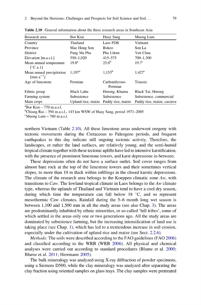
northern Vietnam (Table 2.10). All these limestone areas underwent orogeny with
tectonic movements during the Cretaceous to Paleogene periods, and frequent
earthquakes to this day indicate still ongoing tectonic activity. Therefore, the
landscapes, or rather the land surfaces, are relatively young, and the semi-humid
tropical climate together with these tectonic uplifts have led to intensive karstification,
with the presence of prominent limestone towers, and karst depressions in-between.
These depressions often do not have a surface outlet. Soil cover ranges from
almost bare rock at the top of the limestone towers and their sometimes vertical
slopes, to more than 10 m thick within infillings in the closed karstic depressions.
The climate of the research area belongs to the Koeppen climatic zone Aw, with
transitions to Caw. The lowland tropical climate in Laos belongs to the Aw climate
type, whereas the uplands of Thailand and Vietnam tend to have a cool dry season,
during which time the temperature can fall below 18
C, and so represent
mesothermic Caw climates. Rainfall during the 5–6 month long wet season is
between 1,100 and 1,500 mm in all the study areas (see also Chap. 3). The areas
are predominantly inhabited by ethnic minorities, or so-called ‘hill tribes’, some of
which settled in the areas only one or two generations ago. All the study areas are
dominated by subsistence farming, but the increasing intensification of land use is
taking place (see Chap. 1), which has led to a tremendous increase in soil erosion,
especially under the cultivation of upland rice and maize (see Sect. 2.2.6).
Methods: The soils were described according to the FAO guidelines (FAO 2006)
and classified according to the WRB (WRB 2006). All physical and chemical
analyses were carried out according to standard procedures (Blume et al. 2000;
Blume et al. 2011; Herrmann 2005).
The bulk mineralogy was analyzed using X-ray diffraction of powder specimens,
using a Siemens D500, while the clay mineralogy was analyzed after separating the
clay fraction using oriented samples on glass trays. The clay samples were pretreated
Table 2.10 General information about the three research areas in Southeast Asia
Research area
Bor Krai
Huay Sang
Muong Lum
Country
Thailand
Laos PDR
Vietnam
Province
Mae Hong Son
Bokeo
Son La
District
Pang Ma Pha
Pha Udom
Yen Chau
Elevation [m.a.s.l.]
550–1,020
415–575
700–1,300
Mean annual temperature
[
C a-1]
19.8
a
25.6
b
19.7
c
Mean annual precipitation
[mm a
À1
]
1,197
a
1,153
b
1,427
c
Age of limestone
Permian
CarboniferousPermian
Triassic
Ethnic group
Black Lahu
Hmong, Khamu
Black Tai, Hmong
Farming system
Subsistence
Subsistence
Subsistence, commercial
Main crops
Upland rice, maize Paddy rice, maize Paddy rice, maize, cassava
a
Bor Krai – 770 m.a.s.l.
b
Chiang Rai – 394 m.a.s.l., 143 km WSW of Huay Sang, period 1971–2005
c
Muong Lum – 780 m.a.s.l.
2 Beyond the Horizons: Challenges and Prospects for Soil Science and Soil. . .
79
tectonic movements during the Cretaceous to Paleogene periods, and frequent
earthquakes to this day indicate still ongoing tectonic activity. Therefore, the
landscapes, or rather the land surfaces, are relatively young, and the semi-humid
tropical climate together with these tectonic uplifts have led to intensive karstification,
with the presence of prominent limestone towers, and karst depressions in-between.
These depressions often do not have a surface outlet. Soil cover ranges from
almost bare rock at the top of the limestone towers and their sometimes vertical
slopes, to more than 10 m thick within infillings in the closed karstic depressions.
The climate of the research area belongs to the Koeppen climatic zone Aw, with
transitions to Caw. The lowland tropical climate in Laos belongs to the Aw climate
type, whereas the uplands of Thailand and Vietnam tend to have a cool dry season,
during which time the temperature can fall below 18
C, and so represent
mesothermic Caw climates. Rainfall during the 5–6 month long wet season is
between 1,100 and 1,500 mm in all the study areas (see also Chap. 3). The areas
are predominantly inhabited by ethnic minorities, or so-called ‘hill tribes’, some of
which settled in the areas only one or two generations ago. All the study areas are
dominated by subsistence farming, but the increasing intensification of land use is
taking place (see Chap. 1), which has led to a tremendous increase in soil erosion,
especially under the cultivation of upland rice and maize (see Sect. 2.2.6).
Methods: The soils were described according to the FAO guidelines (FAO 2006)
and classified according to the WRB (WRB 2006). All physical and chemical
analyses were carried out according to standard procedures (Blume et al. 2000;
Blume et al. 2011; Herrmann 2005).
The bulk mineralogy was analyzed using X-ray diffraction of powder specimens,
using a Siemens D500, while the clay mineralogy was analyzed after separating the
clay fraction using oriented samples on glass trays. The clay samples were pretreated
Table 2.10 General information about the three research areas in Southeast Asia
Research area
Bor Krai
Huay Sang
Muong Lum
Country
Thailand
Laos PDR
Vietnam
Province
Mae Hong Son
Bokeo
Son La
District
Pang Ma Pha
Pha Udom
Yen Chau
Elevation [m.a.s.l.]
550–1,020
415–575
700–1,300
Mean annual temperature
[
C a-1]
19.8
a
25.6
b
19.7
c
Mean annual precipitation
[mm a
À1
]
1,197
a
1,153
b
1,427
c
Age of limestone
Permian
CarboniferousPermian
Triassic
Ethnic group
Black Lahu
Hmong, Khamu
Black Tai, Hmong
Farming system
Subsistence
Subsistence
Subsistence, commercial
Main crops
Upland rice, maize Paddy rice, maize Paddy rice, maize, cassava
a
Bor Krai – 770 m.a.s.l.
b
Chiang Rai – 394 m.a.s.l., 143 km WSW of Huay Sang, period 1971–2005
c
Muong Lum – 780 m.a.s.l.
2 Beyond the Horizons: Challenges and Prospects for Soil Science and Soil. . .
79