

Transfer (CSM-DSSAT) tool (Jones et al. 2003) with spatial databases and climate
change scenarios taken from the Atmospheric General Circulation Model
(ECHAM4) (Roeckner et al. 1996) climate model. In a case study on rice production
systems, we demonstrated the capability of CropDSS to assess the impacts of climate
change and evaluate adaptation options.
10.3.1.1 CropDSS Framework
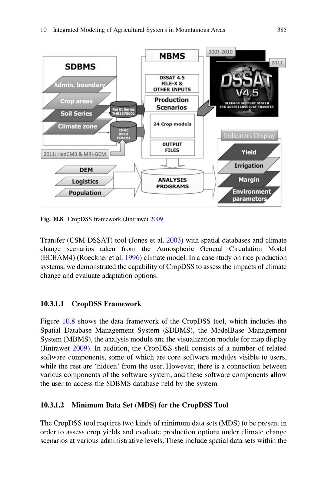
Figure 10.8 shows the data framework of the CropDSS tool, which includes the
Spatial Database Management System (SDBMS), the ModelBase Management
System (MBMS), the analysis module and the visualization module for map display
(Jintrawet 2009). In addition, the CropDSS shell consists of a number of related
software components, some of which are core software modules visible to users,
while the rest are ‘hidden’ from the user. However, there is a connection between
various components of the software system, and these software components allow
the user to access the SDBMS database held by the system.
10.3.1.2 Minimum Data Set (MDS) for the CropDSS Tool
The CropDSS tool requires two kinds of minimum data sets (MDS) to be present in
order to assess crop yields and evaluate production options under climate change
scenarios at various administrative levels. These include spatial data sets within the
Fig. 10.8 CropDSS framework (Jintrawet 2009)
10 Integrated Modeling of Agricultural Systems in Mountainous Areas
385
change scenarios taken from the Atmospheric General Circulation Model
(ECHAM4) (Roeckner et al. 1996) climate model. In a case study on rice production
systems, we demonstrated the capability of CropDSS to assess the impacts of climate
change and evaluate adaptation options.
10.3.1.1 CropDSS Framework
Figure 10.8 shows the data framework of the CropDSS tool, which includes the
Spatial Database Management System (SDBMS), the ModelBase Management
System (MBMS), the analysis module and the visualization module for map display
(Jintrawet 2009). In addition, the CropDSS shell consists of a number of related
software components, some of which are core software modules visible to users,
while the rest are ‘hidden’ from the user. However, there is a connection between
various components of the software system, and these software components allow
the user to access the SDBMS database held by the system.
10.3.1.2 Minimum Data Set (MDS) for the CropDSS Tool
The CropDSS tool requires two kinds of minimum data sets (MDS) to be present in
order to assess crop yields and evaluate production options under climate change
scenarios at various administrative levels. These include spatial data sets within the
Fig. 10.8 CropDSS framework (Jintrawet 2009)
10 Integrated Modeling of Agricultural Systems in Mountainous Areas
385