

helping to find answers that pave the way for the successful establishment of SCT.
To this end, the following section presents selected examples of research- and
farmer-based approaches taken to assess the effectiveness of SCT and to monitor
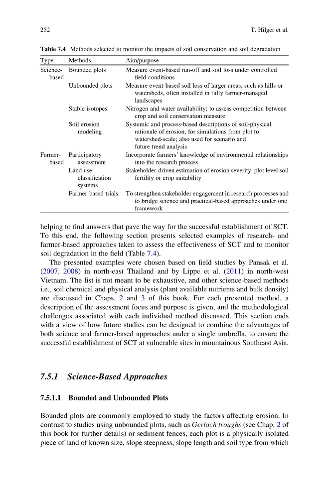
soil degradation in the field (Table 7.4).
The presented examples were chosen based on field studies by Pansak et al.
(2007, 2008) in north-east Thailand and by Lippe et al. (2011) in north-west
Vietnam. The list is not meant to be exhaustive, and other science-based methods
i.e., soil chemical and physical analysis (plant available nutrients and bulk density)
are discussed in Chaps. 2 and 3 of this book. For each presented method, a
description of the assessment focus and purpose is given, and the methodological
challenges associated with each individual method discussed. This section ends
with a view of how future studies can be designed to combine the advantages of
both science and farmer-based approaches under a single umbrella, to ensure the
successful establishment of SCT at vulnerable sites in mountainous Southeast Asia.
7.5.1 Science-Based Approaches
7.5.1.1 Bounded and Unbounded Plots
Bounded plots are commonly employed to study the factors affecting erosion. In
contrast to studies using unbounded plots, such as Gerlach troughs (see Chap. 2 of
this book for further details) or sediment fences, each plot is a physically isolated
piece of land of known size, slope steepness, slope length and soil type from which
Table 7.4 Methods selected to monitor the impacts of soil conservation and soil degradation
Type
Methods
Aim/purpose
Sciencebased
Bounded plots
Measure event-based run-off and soil loss under controlled
field-conditions
Unbounded plots
Measure event-based soil loss of larger areas, such as hills or
watersheds, often installed in fully farmer-managed
landscapes
Stable isotopes
Nitrogen and water availability; to assess competition between
crop and soil conservation measure
Soil erosion
modeling
Systemic and process-based descriptions of soil-physical
rationale of erosion, for simulations from plot to
watershed-scale; also used for scenario and
future trend analysis
Farmerbased
Participatory
assessment
Incorporate farmers’ knowledge of environmental relationships
into the research process
Land use
classification
systems
Stakeholder-driven estimation of erosion severity, plot level soil
fertility or crop suitability
Farmer-based trials To strengthen stakeholder engagement in research processes and
to bridge science and practical-based approaches under one
framework
252
T. Hilger et al.
To this end, the following section presents selected examples of research- and
farmer-based approaches taken to assess the effectiveness of SCT and to monitor
soil degradation in the field (Table 7.4).
The presented examples were chosen based on field studies by Pansak et al.
(2007, 2008) in north-east Thailand and by Lippe et al. (2011) in north-west
Vietnam. The list is not meant to be exhaustive, and other science-based methods
i.e., soil chemical and physical analysis (plant available nutrients and bulk density)
are discussed in Chaps. 2 and 3 of this book. For each presented method, a
description of the assessment focus and purpose is given, and the methodological
challenges associated with each individual method discussed. This section ends
with a view of how future studies can be designed to combine the advantages of
both science and farmer-based approaches under a single umbrella, to ensure the
successful establishment of SCT at vulnerable sites in mountainous Southeast Asia.
7.5.1 Science-Based Approaches
7.5.1.1 Bounded and Unbounded Plots
Bounded plots are commonly employed to study the factors affecting erosion. In
contrast to studies using unbounded plots, such as Gerlach troughs (see Chap. 2 of
this book for further details) or sediment fences, each plot is a physically isolated
piece of land of known size, slope steepness, slope length and soil type from which
Table 7.4 Methods selected to monitor the impacts of soil conservation and soil degradation
Type
Methods
Aim/purpose
Sciencebased
Bounded plots
Measure event-based run-off and soil loss under controlled
field-conditions
Unbounded plots
Measure event-based soil loss of larger areas, such as hills or
watersheds, often installed in fully farmer-managed
landscapes
Stable isotopes
Nitrogen and water availability; to assess competition between
crop and soil conservation measure
Soil erosion
modeling
Systemic and process-based descriptions of soil-physical
rationale of erosion, for simulations from plot to
watershed-scale; also used for scenario and
future trend analysis
Farmerbased
Participatory
assessment
Incorporate farmers’ knowledge of environmental relationships
into the research process
Land use
classification
systems
Stakeholder-driven estimation of erosion severity, plot level soil
fertility or crop suitability
Farmer-based trials To strengthen stakeholder engagement in research processes and
to bridge science and practical-based approaches under one
framework
252
T. Hilger et al.