

models. The southern peninsular India, Ganges, and
Brahmaputra basins are projected to experience floods of
similar magnitude at a higher frequency (<15 years) in the
twenty-first century, with high consistency among the
models (Hirabayashi et al. 2013). The majority of studies
projected an increasing flood risk for Indus-GangaBrahmaputra river basins (Higgins et al. 2014; Shrestha
et al. 2015; Kay et al. 2015; Wijngaard et al. 2017; Lutz
et al. 2019) and these basins are considered as hotspots in a
changing climate (De Souza et al. 2015). The increased flood
risk in terms of frequency and duration of flood events can
exert profound impacts on food production, water resources
and management. Additionally, the human-induced influences such as land-use changes, irrigation, mismanagement
of dams and reservoirs can aggravate the magnitude and the
frequency of flood events in the future.
6.5 Knowledge Gaps
This section highlights some of the knowledge gaps that
would be of relevance for future studies on drought and
flood assessments.
1. Lack of dense observational networks for essential climate variables like soil moisture, surface and sub-surface
energy, water fluxes, stream flow, etc. limits our scientific understanding of the complex multiscale (spatial and
temporal) interactions taking place in the climate system.
To better understand the processes involved in the variations of intensity and duration of floods and droughts
over India in a warming climate, novel observational
datasets are highly required. For example, network of the
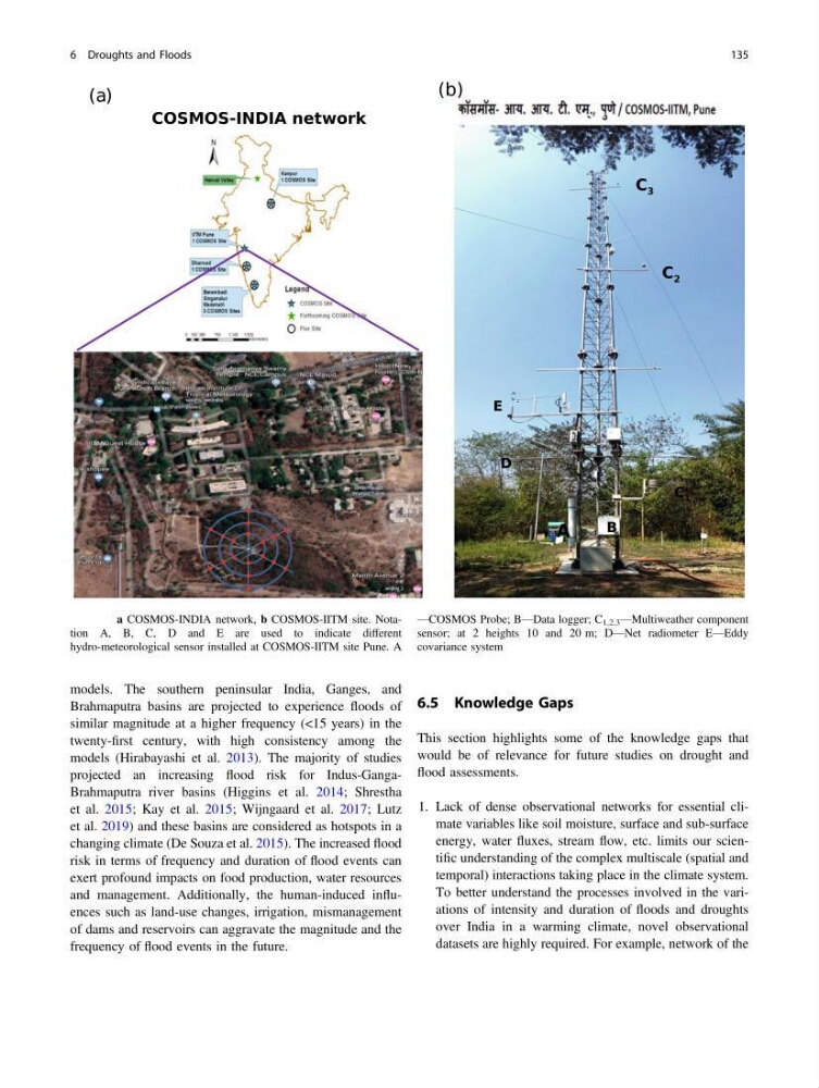
Fig. 6.9 a COSMOS-INDIA network, b COSMOS-IITM site. Notation A, B, C, D and E are used to indicate different
hydro-meteorological sensor installed at COSMOS-IITM site Pune. A
—COSMOS Probe; B—Data logger; C 1,2,3 —Multiweather component
sensor; at 2 heights 10 and 20 m; D—Net radiometer E—Eddy
covariance system
6 Droughts and Floods
135
Brahmaputra basins are projected to experience floods of
similar magnitude at a higher frequency (<15 years) in the
twenty-first century, with high consistency among the
models (Hirabayashi et al. 2013). The majority of studies
projected an increasing flood risk for Indus-GangaBrahmaputra river basins (Higgins et al. 2014; Shrestha
et al. 2015; Kay et al. 2015; Wijngaard et al. 2017; Lutz
et al. 2019) and these basins are considered as hotspots in a
changing climate (De Souza et al. 2015). The increased flood
risk in terms of frequency and duration of flood events can
exert profound impacts on food production, water resources
and management. Additionally, the human-induced influences such as land-use changes, irrigation, mismanagement
of dams and reservoirs can aggravate the magnitude and the
frequency of flood events in the future.
6.5 Knowledge Gaps
This section highlights some of the knowledge gaps that
would be of relevance for future studies on drought and
flood assessments.
1. Lack of dense observational networks for essential climate variables like soil moisture, surface and sub-surface
energy, water fluxes, stream flow, etc. limits our scientific understanding of the complex multiscale (spatial and
temporal) interactions taking place in the climate system.
To better understand the processes involved in the variations of intensity and duration of floods and droughts
over India in a warming climate, novel observational
datasets are highly required. For example, network of the
Fig. 6.9 a COSMOS-INDIA network, b COSMOS-IITM site. Notation A, B, C, D and E are used to indicate different
hydro-meteorological sensor installed at COSMOS-IITM site Pune. A
—COSMOS Probe; B—Data logger; C 1,2,3 —Multiweather component
sensor; at 2 heights 10 and 20 m; D—Net radiometer E—Eddy
covariance system
6 Droughts and Floods
135