

116
R. Orosei
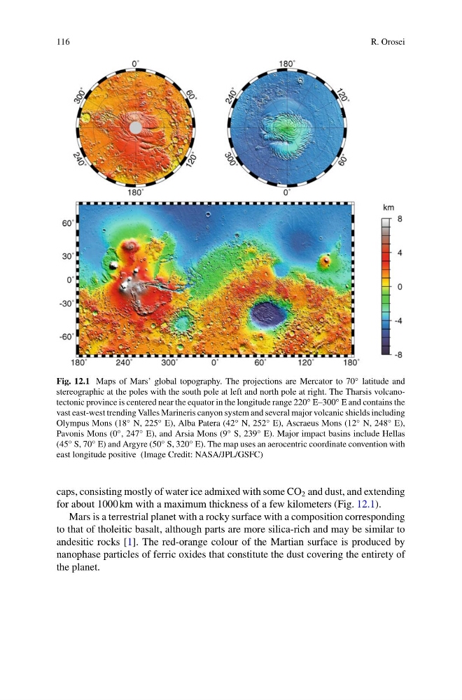
Fig. 12.1 Maps of Mars’ global topography. The projections are Mercator to 70 ◦ latitude and
stereographic at the poles with the south pole at left and north pole at right. The Tharsis volcanotectonic province is centered near the equator in the longitude range 220 ◦ E–300 ◦ E and contains the
vast east-west trending Valles Marineris canyon system and several major volcanic shields including
Olympus Mons (18 ◦ N, 225 ◦ E), Alba Patera (42 ◦ N, 252 ◦ E), Ascraeus Mons (12 ◦ N, 248 ◦ E),
Pavonis Mons (0 ◦ , 247 ◦ E), and Arsia Mons (9 ◦ S, 239 ◦ E). Major impact basins include Hellas
(45 ◦ S, 70 ◦ E) and Argyre (50 ◦ S, 320 ◦ E). The map uses an aerocentric coordinate convention with
east longitude positive (Image Credit: NASA/JPL/GSFC)
caps, consisting mostly of water ice admixed with some CO 2 and dust, and extending
for about 1000 km with a maximum thickness of a few kilometers (Fig. 12.1).
Mars is a terrestrial planet with a rocky surface with a composition corresponding
to that of tholeitic basalt, although parts are more silica-rich and may be similar to
andesitic rocks [1]. The red-orange colour of the Martian surface is produced by
nanophase particles of ferric oxides that constitute the dust covering the entirety of
the planet.
R. Orosei
Fig. 12.1 Maps of Mars’ global topography. The projections are Mercator to 70 ◦ latitude and
stereographic at the poles with the south pole at left and north pole at right. The Tharsis volcanotectonic province is centered near the equator in the longitude range 220 ◦ E–300 ◦ E and contains the
vast east-west trending Valles Marineris canyon system and several major volcanic shields including
Olympus Mons (18 ◦ N, 225 ◦ E), Alba Patera (42 ◦ N, 252 ◦ E), Ascraeus Mons (12 ◦ N, 248 ◦ E),
Pavonis Mons (0 ◦ , 247 ◦ E), and Arsia Mons (9 ◦ S, 239 ◦ E). Major impact basins include Hellas
(45 ◦ S, 70 ◦ E) and Argyre (50 ◦ S, 320 ◦ E). The map uses an aerocentric coordinate convention with
east longitude positive (Image Credit: NASA/JPL/GSFC)
caps, consisting mostly of water ice admixed with some CO 2 and dust, and extending
for about 1000 km with a maximum thickness of a few kilometers (Fig. 12.1).
Mars is a terrestrial planet with a rocky surface with a composition corresponding
to that of tholeitic basalt, although parts are more silica-rich and may be similar to
andesitic rocks [1]. The red-orange colour of the Martian surface is produced by
nanophase particles of ferric oxides that constitute the dust covering the entirety of
the planet.