

between November and April, it falls at approximately 1600–1700 m a.s.l.
(García-Ruiz et al. 1986), representing the lower limit of the stable winter snow
cover. In the mountains, annual precipitation exceeds 2000 mm and sometimes
reaches more than 2500 mm in the highest divides (García-Ruiz et al. 2001). Most
of the annual precipitation falls during the cold season in the western areas, and
during spring and autumn in the eastern regions.
Snow depth and duration in the Pyrenees show a marked spatial variability and
vertical gradients. There exists a trend towards greater and more prolonged accumulation of snow in areas exposed to Atlantic climatic conditions (westward)
compared with areas influenced by Mediterranean conditions (eastward)
(López-Moreno et al. 2009). The vertical gradient in accumulated snow is evident,
with values ranging between 121 mm (accumulated snow water equivalent) at
1500 m a.s.l., and 908 mm at 3000 m. a.s.l. The duration of snowpack shows a
marked increase with altitude, ranging from an average of 50.1 days at 1500 m to
263.7 days at 3000 m a.s.l. (López-Moreno et al. 2009).
In general, the timing of snow accumulation and snowmelt markedly modulates
the regimes of Pyrenean rivers, as most of the winter precipitation falls as snow in
the Pyrenees (López-Moreno and Garcia-Ruiz 2004). Thus flows during winter
(December–February) are low and uniform, and flows during spring/beginning of
summer (March–July) are greater and have fluctuations (García-Ruíz et al. 1986;
Beguería et al. 2003; López-Moreno and García-Ruiz 2004; Bejarano et al. 2010).
Regional discharge contrasts have been assessed in relation to basin elevation and
the longitudinal climate gradient established in the mountain range (López-Moreno
and García-Ruiz 2004). Where large snow accumulation is possible, at the highest
and more continental massifs, a delay in the onset of snow melting (mid-April on
average) and higher spring flows is usually observed. Downstream the peak spring
discharges decrease in intensity and the low winter discharges increase (Beguería
et al. 2003).
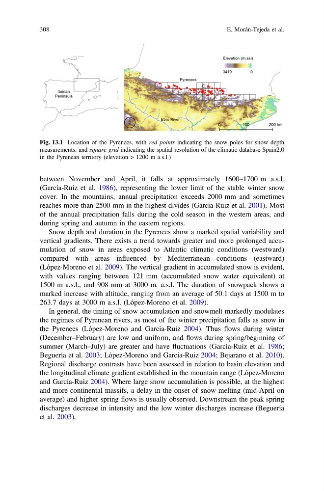
Fig. 13.1 Location of the Pyrenees, with red points indicating the snow poles for snow depth
measurements, and square grid indicating the spatial resolution of the climatic database Spain2.0
in the Pyrenean territory (elevation > 1200 m a.s.l.)
308
E. Morán-Tejeda et al.
(García-Ruiz et al. 1986), representing the lower limit of the stable winter snow
cover. In the mountains, annual precipitation exceeds 2000 mm and sometimes
reaches more than 2500 mm in the highest divides (García-Ruiz et al. 2001). Most
of the annual precipitation falls during the cold season in the western areas, and
during spring and autumn in the eastern regions.
Snow depth and duration in the Pyrenees show a marked spatial variability and
vertical gradients. There exists a trend towards greater and more prolonged accumulation of snow in areas exposed to Atlantic climatic conditions (westward)
compared with areas influenced by Mediterranean conditions (eastward)
(López-Moreno et al. 2009). The vertical gradient in accumulated snow is evident,
with values ranging between 121 mm (accumulated snow water equivalent) at
1500 m a.s.l., and 908 mm at 3000 m. a.s.l. The duration of snowpack shows a
marked increase with altitude, ranging from an average of 50.1 days at 1500 m to
263.7 days at 3000 m a.s.l. (López-Moreno et al. 2009).
In general, the timing of snow accumulation and snowmelt markedly modulates
the regimes of Pyrenean rivers, as most of the winter precipitation falls as snow in
the Pyrenees (López-Moreno and Garcia-Ruiz 2004). Thus flows during winter
(December–February) are low and uniform, and flows during spring/beginning of
summer (March–July) are greater and have fluctuations (García-Ruíz et al. 1986;
Beguería et al. 2003; López-Moreno and García-Ruiz 2004; Bejarano et al. 2010).
Regional discharge contrasts have been assessed in relation to basin elevation and
the longitudinal climate gradient established in the mountain range (López-Moreno
and García-Ruiz 2004). Where large snow accumulation is possible, at the highest
and more continental massifs, a delay in the onset of snow melting (mid-April on
average) and higher spring flows is usually observed. Downstream the peak spring
discharges decrease in intensity and the low winter discharges increase (Beguería
et al. 2003).
Fig. 13.1 Location of the Pyrenees, with red points indicating the snow poles for snow depth
measurements, and square grid indicating the spatial resolution of the climatic database Spain2.0
in the Pyrenean territory (elevation > 1200 m a.s.l.)
308
E. Morán-Tejeda et al.