

from nearby stations, the climate in the study area can be described as continental
with oceanic (western sites) or Mediterranean (eastern and southern sites) influences. The westward oceanic influence leads to greater precipitation in winter and a
smaller temperature range than eastwards. This oceanic influence decreases eastwards where the Mediterranean influence prevails being characterised by higher
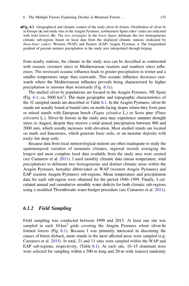
precipitation in summer than westwards (Fig. 6.1c).
The studied silver-fir populations are located in the Aragón Pyrenees, NE Spain
(Fig. 6.1; ca. 5600 km
2 ). The main geographic and topographic characteristics of
the 32 sampled stands are described in Table 6.1. In the Aragón Pyrenees, silver-fir
stands are usually found at humid sites on north-facing slopes where they form pure
or mixed stands with European beech (Fagus sylvatica L.) or Scots pine (Pinus
sylvestris L.). Silver-fir forests in the study area may experience summer drought
stress in August, despite they receive a total annual precipitation between 900 and
2000 mm, which usually increases with elevation. Most studied stands are located
on marls and limestones, which generate basic soils, or on moraine deposits with
rocky but deep soils.
Because data from local meteorological stations are often inadequate to study the
spatiotemporal variation of mountain climates, regional records averaging the
longest and most complete local data available from the study area were created
(see Camarero et al. 2011). I used monthly climatic data (mean temperature, total
precipitation) to delineate two homogeneous and distinct climatic areas within the
Aragón Pyrenees, hereafter abbreviated as WAP (western Aragón Pyrenees) and
EAP (eastern Aragón Pyrenees) sub-regions. Mean temperature and precipitation
data for each sub-region were obtained for the period 1940–1999. Finally, I calculated annual and cumulative monthly water deficits for both climatic sub-regions
using a modified Thornthwaite water-budget procedure (see Camarero et al. 2011).
6.1.2 Field Sampling
Field sampling was conducted between 1999 and 2015. At least one site was
sampled in each 10-km
2 grids covering the Aragón Pyrenees where silver-fir
formed forests (Fig. 6.1). Because I was primarily interested in discerning the
causes of forest dieback, more stands in the most affected areas were sampled (e.g.
Camarero et al. 2015). In total, 21 and 11 sites were sampled within the WAP and
EAP sub-regions, respectively, (Table 6.1). At each site, 10–15 dominant trees
were selected for sampling within a 500-m long and 20-m wide transect randomly
JFig. 6.1 Geographical and climatic context of the study silver-fir forests. Distribution of silver fir
in Europe (a) and study sites in the Aragón Pyrenees, northeastern Spain (sites’ codes are indicated
with bold letters) (b). The two rectangles in the lower figure delineate the two homogeneous
climatic sub-regions based on local data from the displayed climatic stations (indicated by
three-letter codes): Western (WAP) and Eastern (EAP) Aragón Pyrenees. c The longitudinal
gradient of percent summer precipitation in the study area interpolated through kriging
6 The Multiple Factors Explaining Decline in Mountain Forests …
135
with oceanic (western sites) or Mediterranean (eastern and southern sites) influences. The westward oceanic influence leads to greater precipitation in winter and a
smaller temperature range than eastwards. This oceanic influence decreases eastwards where the Mediterranean influence prevails being characterised by higher
precipitation in summer than westwards (Fig. 6.1c).
The studied silver-fir populations are located in the Aragón Pyrenees, NE Spain
(Fig. 6.1; ca. 5600 km
2 ). The main geographic and topographic characteristics of
the 32 sampled stands are described in Table 6.1. In the Aragón Pyrenees, silver-fir
stands are usually found at humid sites on north-facing slopes where they form pure
or mixed stands with European beech (Fagus sylvatica L.) or Scots pine (Pinus
sylvestris L.). Silver-fir forests in the study area may experience summer drought
stress in August, despite they receive a total annual precipitation between 900 and
2000 mm, which usually increases with elevation. Most studied stands are located
on marls and limestones, which generate basic soils, or on moraine deposits with
rocky but deep soils.
Because data from local meteorological stations are often inadequate to study the
spatiotemporal variation of mountain climates, regional records averaging the
longest and most complete local data available from the study area were created
(see Camarero et al. 2011). I used monthly climatic data (mean temperature, total
precipitation) to delineate two homogeneous and distinct climatic areas within the
Aragón Pyrenees, hereafter abbreviated as WAP (western Aragón Pyrenees) and
EAP (eastern Aragón Pyrenees) sub-regions. Mean temperature and precipitation
data for each sub-region were obtained for the period 1940–1999. Finally, I calculated annual and cumulative monthly water deficits for both climatic sub-regions
using a modified Thornthwaite water-budget procedure (see Camarero et al. 2011).
6.1.2 Field Sampling
Field sampling was conducted between 1999 and 2015. At least one site was
sampled in each 10-km
2 grids covering the Aragón Pyrenees where silver-fir
formed forests (Fig. 6.1). Because I was primarily interested in discerning the
causes of forest dieback, more stands in the most affected areas were sampled (e.g.
Camarero et al. 2015). In total, 21 and 11 sites were sampled within the WAP and
EAP sub-regions, respectively, (Table 6.1). At each site, 10–15 dominant trees
were selected for sampling within a 500-m long and 20-m wide transect randomly
JFig. 6.1 Geographical and climatic context of the study silver-fir forests. Distribution of silver fir
in Europe (a) and study sites in the Aragón Pyrenees, northeastern Spain (sites’ codes are indicated
with bold letters) (b). The two rectangles in the lower figure delineate the two homogeneous
climatic sub-regions based on local data from the displayed climatic stations (indicated by
three-letter codes): Western (WAP) and Eastern (EAP) Aragón Pyrenees. c The longitudinal
gradient of percent summer precipitation in the study area interpolated through kriging
6 The Multiple Factors Explaining Decline in Mountain Forests …
135