

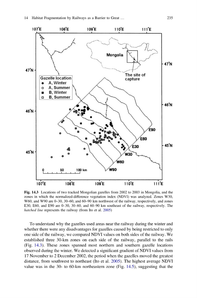
Fig. 14.3 Locations of two tracked Mongolian gazelles from 2002 to 2003 in Mongolia, and the
zones in which the normalized-difference vegetation index (NDVI) was analyzed. Zones W30,
W60, and W90 are 0–30, 30–60, and 60–90 km northwest of the railway, respectively, and zones
E30, E60, and E90 are 0–30, 30–60, and 60–90 km southeast of the railway, respectively. The
hatched line represents the railway (from Ito et al. 2005)
To understand why the gazelles used areas near the railway during the winter and
whether there were any disadvantages for gazelles caused by being restricted to only
one side of the railway, we compared NDVI values on both sides of the railway. We
established three 30-km zones on each side of the railway, parallel to the rails
(Fig. 14.3). These zones spanned most northern and southern gazelle locations
observed during the winter. We detected a significant gradient of NDVI values from
17 November to 2 December 2002, the period when the gazelles moved the greatest
distance, from southwest to northeast (Ito et al. 2005). The highest average NDVI
value was in the 30- to 60-km northeastern zone (Fig. 14.5), suggesting that the
14 Habitat Fragmentation by Railways as a Barrier to Great …
235
zones in which the normalized-difference vegetation index (NDVI) was analyzed. Zones W30,
W60, and W90 are 0–30, 30–60, and 60–90 km northwest of the railway, respectively, and zones
E30, E60, and E90 are 0–30, 30–60, and 60–90 km southeast of the railway, respectively. The
hatched line represents the railway (from Ito et al. 2005)
To understand why the gazelles used areas near the railway during the winter and
whether there were any disadvantages for gazelles caused by being restricted to only
one side of the railway, we compared NDVI values on both sides of the railway. We
established three 30-km zones on each side of the railway, parallel to the rails
(Fig. 14.3). These zones spanned most northern and southern gazelle locations
observed during the winter. We detected a significant gradient of NDVI values from
17 November to 2 December 2002, the period when the gazelles moved the greatest
distance, from southwest to northeast (Ito et al. 2005). The highest average NDVI
value was in the 30- to 60-km northeastern zone (Fig. 14.5), suggesting that the
14 Habitat Fragmentation by Railways as a Barrier to Great …
235