

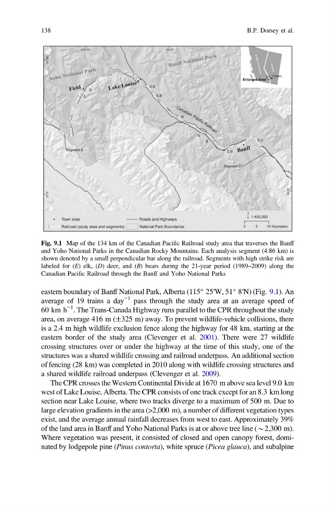
eastern boundary of Banff National Park, Alberta (115° 25′W, 51° 8′N) (Fig. 9.1). An
average of 19 trains a day
−1 pass through the study area at an average speed of
60 km h
−1
. The Trans-Canada Highway runs parallel to the CPR throughout the study
area, on average 416 m (±325 m) away. To prevent wildlife-vehicle collisions, there
is a 2.4 m high wildlife exclusion fence along the highway for 48 km, starting at the
eastern border of the study area (Clevenger et al. 2001). There were 27 wildlife
crossing structures over or under the highway at the time of this study, one of the
structures was a shared wildlife crossing and railroad underpass. An additional section
of fencing (28 km) was completed in 2010 along with wildlife crossing structures and
a shared wildlife railroad underpass (Clevenger et al. 2009).
The CPR crosses the Western Continental Divide at 1670 m above sea level 9.0 km
west of Lake Louise, Alberta. The CPR consists of one track except for an 8.3 km long
section near Lake Louise, where two tracks diverge to a maximum of 500 m. Due to
large elevation gradients in the area (>2,000 m), a number of different vegetation types
exist, and the average annual rainfall decreases from west to east. Approximately 39%
of the land area in Banff and Yoho National Parks is at or above tree line (*2,300 m).
Where vegetation was present, it consisted of closed and open canopy forest, dominated by lodgepole pine (Pinus contorta), white spruce (Picea glauca), and subalpine
Fig. 9.1 Map of the 134 km of the Canadian Pacific Railroad study area that traverses the Banff
and Yoho National Parks in the Canadian Rocky Mountains. Each analysis segment (4.86 km) is
shown denoted by a small perpendicular bar along the railroad. Segments with high strike risk are
labeled for (E) elk, (D) deer, and (B) bears during the 21-year period (1989–2009) along the
Canadian Pacific Railroad through the Banff and Yoho National Parks
138
B.P. Dorsey et al.
average of 19 trains a day
−1 pass through the study area at an average speed of
60 km h
−1
. The Trans-Canada Highway runs parallel to the CPR throughout the study
area, on average 416 m (±325 m) away. To prevent wildlife-vehicle collisions, there
is a 2.4 m high wildlife exclusion fence along the highway for 48 km, starting at the
eastern border of the study area (Clevenger et al. 2001). There were 27 wildlife
crossing structures over or under the highway at the time of this study, one of the
structures was a shared wildlife crossing and railroad underpass. An additional section
of fencing (28 km) was completed in 2010 along with wildlife crossing structures and
a shared wildlife railroad underpass (Clevenger et al. 2009).
The CPR crosses the Western Continental Divide at 1670 m above sea level 9.0 km
west of Lake Louise, Alberta. The CPR consists of one track except for an 8.3 km long
section near Lake Louise, where two tracks diverge to a maximum of 500 m. Due to
large elevation gradients in the area (>2,000 m), a number of different vegetation types
exist, and the average annual rainfall decreases from west to east. Approximately 39%
of the land area in Banff and Yoho National Parks is at or above tree line (*2,300 m).
Where vegetation was present, it consisted of closed and open canopy forest, dominated by lodgepole pine (Pinus contorta), white spruce (Picea glauca), and subalpine
Fig. 9.1 Map of the 134 km of the Canadian Pacific Railroad study area that traverses the Banff
and Yoho National Parks in the Canadian Rocky Mountains. Each analysis segment (4.86 km) is
shown denoted by a small perpendicular bar along the railroad. Segments with high strike risk are
labeled for (E) elk, (D) deer, and (B) bears during the 21-year period (1989–2009) along the
Canadian Pacific Railroad through the Banff and Yoho National Parks
138
B.P. Dorsey et al.