

14.4 Functional Supplement to Global Satellite Radio Navigation Systems
275
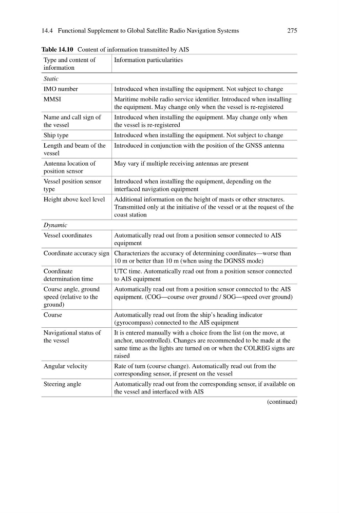
Table 14.10 Content of information transmitted by AIS
Type and content of
information
Information particularities
Static
IMO number
Introduced when installing the equipment. Not subject to change
MMSI
Maritime mobile radio service identifier. Introduced when installing
the equipment. May change only when the vessel is re-registered
Name and call sign of
the vessel
Introduced when installing the equipment. May change only when
the vessel is re-registered
Ship type
Introduced when installing the equipment. Not subject to change
Length and beam of the
vessel
Introduced in conjunction with the position of the GNSS antenna
Antenna location of
position sensor
May vary if multiple receiving antennas are present
Vessel position sensor
type
Introduced when installing the equipment, depending on the
interfaced navigation equipment
Height above keel level Additional information on the height of masts or other structures.
Transmitted only at the initiative of the vessel or at the request of the
coast station
Dynamic
Vessel coordinates
Automatically read out from a position sensor connected to AIS
equipment
Coordinate accuracy sign Characterizes the accuracy of determining coordinates—worse than
10 m or better than 10 m (when using the DGNSS mode)
Coordinate
determination time
UTC time. Automatically read out from a position sensor connected
to AIS equipment
Course angle, ground
speed (relative to the
ground)
Automatically read out from a position sensor connected to the AIS
equipment. (COG—course over ground / SOG—speed over ground)
Course
Automatically read out from the ship’s heading indicator
(gyrocompass) connected to the AIS equipment
Navigational status of
the vessel
It is entered manually with a choice from the list (on the move, at
anchor, uncontrolled). Changes are recommended to be made at the
same time as the lights are turned on or when the COLREG signs are
raised
Angular velocity
Rate of turn (course change). Automatically read out from the
corresponding sensor, if present on the vessel
Steering angle
Automatically read out from the corresponding sensor, if available on
the vessel and interfaced with AIS
(continued)
275
Table 14.10 Content of information transmitted by AIS
Type and content of
information
Information particularities
Static
IMO number
Introduced when installing the equipment. Not subject to change
MMSI
Maritime mobile radio service identifier. Introduced when installing
the equipment. May change only when the vessel is re-registered
Name and call sign of
the vessel
Introduced when installing the equipment. May change only when
the vessel is re-registered
Ship type
Introduced when installing the equipment. Not subject to change
Length and beam of the
vessel
Introduced in conjunction with the position of the GNSS antenna
Antenna location of
position sensor
May vary if multiple receiving antennas are present
Vessel position sensor
type
Introduced when installing the equipment, depending on the
interfaced navigation equipment
Height above keel level Additional information on the height of masts or other structures.
Transmitted only at the initiative of the vessel or at the request of the
coast station
Dynamic
Vessel coordinates
Automatically read out from a position sensor connected to AIS
equipment
Coordinate accuracy sign Characterizes the accuracy of determining coordinates—worse than
10 m or better than 10 m (when using the DGNSS mode)
Coordinate
determination time
UTC time. Automatically read out from a position sensor connected
to AIS equipment
Course angle, ground
speed (relative to the
ground)
Automatically read out from a position sensor connected to the AIS
equipment. (COG—course over ground / SOG—speed over ground)
Course
Automatically read out from the ship’s heading indicator
(gyrocompass) connected to the AIS equipment
Navigational status of
the vessel
It is entered manually with a choice from the list (on the move, at
anchor, uncontrolled). Changes are recommended to be made at the
same time as the lights are turned on or when the COLREG signs are
raised
Angular velocity
Rate of turn (course change). Automatically read out from the
corresponding sensor, if present on the vessel
Steering angle
Automatically read out from the corresponding sensor, if available on
the vessel and interfaced with AIS
(continued)