

212
12 Radar Systems of Maritime Transport
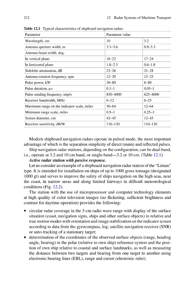
Table 12.1 Typical characteristics of shipboard navigation radars
Parameter
Parameter value
Wavelength, cm
10
3.2
Antenna aperture width, m
3.3–3.6
0.9–3.3
Antenna beam width, deg.
In vertical plane
18–22
17–24
In horizontal plane
1.8–2.3
0.6–1.8
Sidelobe attenuation, dB
23–26
21–28
Antenna rotation frequency, rpm
12–20
15–25
Pulse power, kW
30–80
6–80
Pulse duration, µs
0.1–1
0.05–1
Pulse sending frequency, imp/s
850–4000
625–4000
Receiver bandwidth, MHz
6–12
6–25
Maximum range on the indicator scale, miles
50–64
12–64
Minimum range scale, miles
0.5–1
0.25–1
Screen diameter, cm
42–45
12–45
Receiver sensitivity, dB/W
110–120
110–120
Modern shipboard navigation radars operate in pulsed mode, the most important
advantage of which is the separation simplicity of direct (main) and reflected pulses.
Ship navigation radar stations, depending on the configuration, can be dual-band,
i.e., operate at 3.2 and 10 cm band, or single-band—3.2 or 10 cm. (Table 12.1)
Active radar station with passive response.
Let us consider an example of a shipboard navigation radar station of the “Liman”
type. It is intended for installation on ships of up to 1000 gross tonnage (designated
1000 gt) and serves to improve the safety of ships navigation on the high seas, near
the coast, in narrow areas and along limited fairways in difficult meteorological
conditions (Fig. 12.2).
The station with the use of microprocessor and computer technology elements
at high quality of color television images (no flickering, sufficient brightness and
contrast for daytime operation) provides the following:
• circular radar coverage in the 3-cm radio wave range with display of the surface
situation (coast, navigation signs, ships and other surface objects) in relative and
true motion modes with orientation and image stabilization on the indicator screen
according to data from the gyrocompass, log, satellite navigation receiver (SNR)
or auto-tracking of a stationary target;
• determination of the coordinates of the observed surface objects (range, heading
angle, bearing) in the polar (relative to own ship) reference system and the position of own ship relative to coastal and surface landmarks, as well as measuring
the distance between two targets and bearing from one target to another using
electronic bearing lines (EBL), range and cursor (electronic ruler).
12 Radar Systems of Maritime Transport
Table 12.1 Typical characteristics of shipboard navigation radars
Parameter
Parameter value
Wavelength, cm
10
3.2
Antenna aperture width, m
3.3–3.6
0.9–3.3
Antenna beam width, deg.
In vertical plane
18–22
17–24
In horizontal plane
1.8–2.3
0.6–1.8
Sidelobe attenuation, dB
23–26
21–28
Antenna rotation frequency, rpm
12–20
15–25
Pulse power, kW
30–80
6–80
Pulse duration, µs
0.1–1
0.05–1
Pulse sending frequency, imp/s
850–4000
625–4000
Receiver bandwidth, MHz
6–12
6–25
Maximum range on the indicator scale, miles
50–64
12–64
Minimum range scale, miles
0.5–1
0.25–1
Screen diameter, cm
42–45
12–45
Receiver sensitivity, dB/W
110–120
110–120
Modern shipboard navigation radars operate in pulsed mode, the most important
advantage of which is the separation simplicity of direct (main) and reflected pulses.
Ship navigation radar stations, depending on the configuration, can be dual-band,
i.e., operate at 3.2 and 10 cm band, or single-band—3.2 or 10 cm. (Table 12.1)
Active radar station with passive response.
Let us consider an example of a shipboard navigation radar station of the “Liman”
type. It is intended for installation on ships of up to 1000 gross tonnage (designated
1000 gt) and serves to improve the safety of ships navigation on the high seas, near
the coast, in narrow areas and along limited fairways in difficult meteorological
conditions (Fig. 12.2).
The station with the use of microprocessor and computer technology elements
at high quality of color television images (no flickering, sufficient brightness and
contrast for daytime operation) provides the following:
• circular radar coverage in the 3-cm radio wave range with display of the surface
situation (coast, navigation signs, ships and other surface objects) in relative and
true motion modes with orientation and image stabilization on the indicator screen
according to data from the gyrocompass, log, satellite navigation receiver (SNR)
or auto-tracking of a stationary target;
• determination of the coordinates of the observed surface objects (range, heading
angle, bearing) in the polar (relative to own ship) reference system and the position of own ship relative to coastal and surface landmarks, as well as measuring
the distance between two targets and bearing from one target to another using
electronic bearing lines (EBL), range and cursor (electronic ruler).