

194
J. Fluixá-Sanmartín et al.
Yes
Coordinator of the Local Emergency Operations
Center (COEL):
• monitors the situation
A permanent monitoring is
needed? (Coord. COEL)
Warning
Limited or null danger
External
Information
Alert
External support
(Members of the
INDECI,
Platform or
Upper level of
the Government)
PROCEDURE FOR MONITORING AND EARLY WARNING IN CARHUAZ
Alarm
Members of the COEL:
• inform, when needed, the work group and the first
response teams for their preparation
• elaborate frequent reports and monitor the situation
regularly according to the reports
Members of the COEL:
• order the beginning of the operations de of the first response teams in each zone
Mayor :
• activate the emergency alarm
• order the evacuation processes
Yes
Yes
No
No
No
Yes
No
Yes
Still a permanent monitoring
is needed? (Coord. COEL)
Still an imminent danger
exists? (Coord. COEL)
Members of the COELand the Mayor :
• coordinated and continuous assessment of the situation
Coordinator of the COEL:
• informs the president of the platform and the work groups
• activates simultaneously the preventive warnings of the basin
• informs themedia of the actions using the loudspeakers
Members of the COEL:
• informs the first response teams for their displacement
to potential impact zones
Members of the COEL and the Mayor :
• continuous management of the event
• coordinate with the work group and the first response teams
Emergency situation?
(Mayor )
Deactivation of the alarm
Deactivation of the warning
Deactivation of the
advertisement
No
Automatic
warning
Still an emergency
situation? (Mayor )
Imminent danger?
(Coord. COEL)
Yes
No
Daily
monitoring of
hydro-meteo
and outburst
variables
Coordinator of the COEL:
• informs the president of the platform
• informs the members of the COEL for their displacement to the Emergency
Operations Center
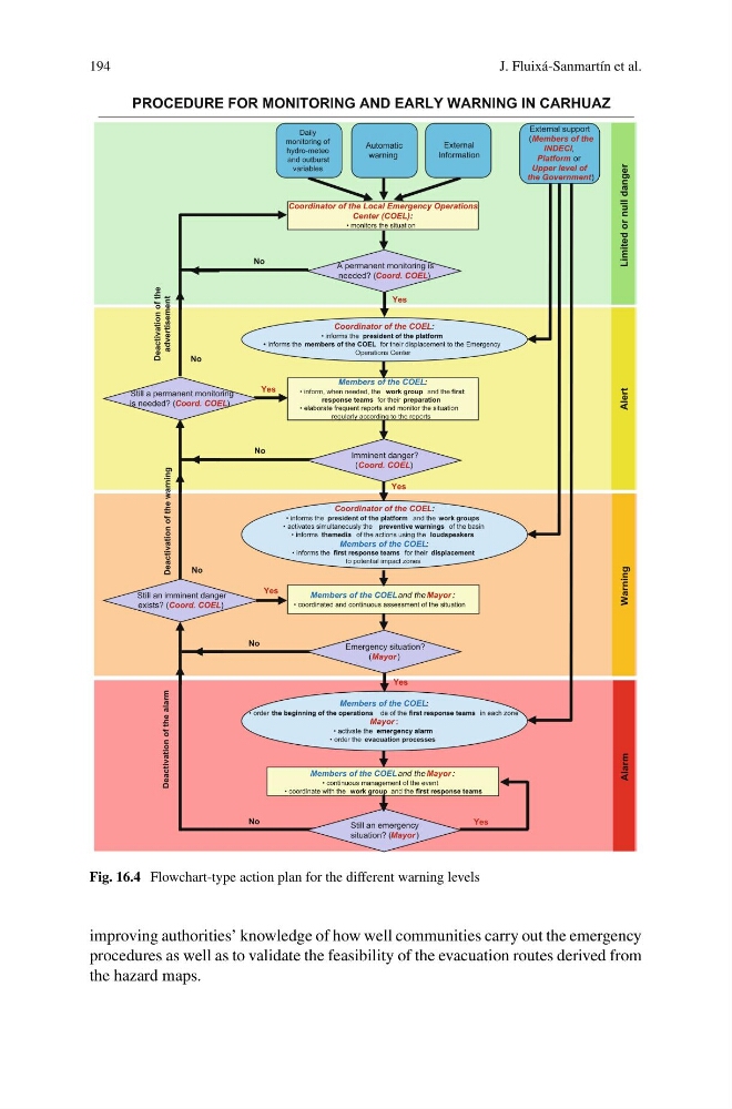
Fig. 16.4 Flowchart-type action plan for the different warning levels
improving authorities’ knowledge of how well communities carry out the emergency
procedures as well as to validate the feasibility of the evacuation routes derived from
the hazard maps.
J. Fluixá-Sanmartín et al.
Yes
Coordinator of the Local Emergency Operations
Center (COEL):
• monitors the situation
A permanent monitoring is
needed? (Coord. COEL)
Warning
Limited or null danger
External
Information
Alert
External support
(Members of the
INDECI,
Platform or
Upper level of
the Government)
PROCEDURE FOR MONITORING AND EARLY WARNING IN CARHUAZ
Alarm
Members of the COEL:
• inform, when needed, the work group and the first
response teams for their preparation
• elaborate frequent reports and monitor the situation
regularly according to the reports
Members of the COEL:
• order the beginning of the operations de of the first response teams in each zone
Mayor :
• activate the emergency alarm
• order the evacuation processes
Yes
Yes
No
No
No
Yes
No
Yes
Still a permanent monitoring
is needed? (Coord. COEL)
Still an imminent danger
exists? (Coord. COEL)
Members of the COELand the Mayor :
• coordinated and continuous assessment of the situation
Coordinator of the COEL:
• informs the president of the platform and the work groups
• activates simultaneously the preventive warnings of the basin
• informs themedia of the actions using the loudspeakers
Members of the COEL:
• informs the first response teams for their displacement
to potential impact zones
Members of the COEL and the Mayor :
• continuous management of the event
• coordinate with the work group and the first response teams
Emergency situation?
(Mayor )
Deactivation of the alarm
Deactivation of the warning
Deactivation of the
advertisement
No
Automatic
warning
Still an emergency
situation? (Mayor )
Imminent danger?
(Coord. COEL)
Yes
No
Daily
monitoring of
hydro-meteo
and outburst
variables
Coordinator of the COEL:
• informs the president of the platform
• informs the members of the COEL for their displacement to the Emergency
Operations Center
Fig. 16.4 Flowchart-type action plan for the different warning levels
improving authorities’ knowledge of how well communities carry out the emergency
procedures as well as to validate the feasibility of the evacuation routes derived from
the hazard maps.