

30
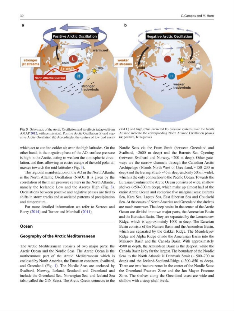
which act to confine colder air over the high latitudes. On the
other hand, in the negative phase of the AO, surface pressure
is high in the Arctic, acting to weaken the atmospheric circulation, and thus, allowing an easier escape of the cold polar air
masses towards the mid-latitudes (Fig. 3).
The regional manifestation of the AO in the North Atlantic
is the North Atlantic Oscillation (NAO). It is given by the
correlation of the main pressure centers in the North Atlantic,
namely the Icelandic Low and the Azores High (Fig. 3).
Oscillations between positive and negative phases are tied to
shifts in storm tracks and associated patterns of precipitation
and temperature.
For more detailed information we refer to Serreze and
Barry (2014) and Turner and Marshall (2011).
Ocean
Geography of the Arctic Mediterranean
The Arctic Mediterranean consists of two major parts: the
Arctic Ocean and the Nordic Seas. The Arctic Ocean is the
northernmost part of the Arctic Mediterranean which is
enclosed by North America, the Eurasian continent, Svalbard,
and Greenland (Fig. 1). The Nordic Seas are enclosed by
Svalbard, Norway, Iceland, Scotland and Greenland and
include the Greenland Sea, Norwegian Sea, and Iceland Sea
(also called the GIN Seas). The Arctic Ocean connects to the
Nordic Seas via the Fram Strait (between Greenland and
Svalbard, ~2600 m deep) and the Barents Sea Opening
(between Svalbard and Norway, ~200 m deep). Other gateways are the narrow channels through the Canadian Arctic
Archipelago (Islands North West of Greenland, ~150–230 m
deep) and the Bering Strait (~45 m deep and only 50 km wide),
which is the only connection to the Pacific Ocean. Towards the
Eurasian Continent the Arctic Ocean consists of wide, shallow
shelves (<50–300 m deep), which make up almost half of the
entire Arctic Ocean and comprise five marginal seas: Barents
Sea, Kara Sea, Laptev Sea, East Siberian Sea and Chuckchi
Sea. At the coasts of North America and Greenland the shelves
are much narrower. The deep basins in the center of the Arctic
Ocean are divided into two major parts, the Amerasian Basin
and the Eurasian Basin. They are separated by the Lomonosov
Ridge, which is approximately 1600 m deep. The Eurasian
Basin consists of the Nansen Basin and the Amundsen Basin,
which are separated by the Gakkel Ridge. The Mendeleyev
Ridge and Alpha Ridge divide the Amerasian Basin into the
Makarov Basin and the Canada Basin. With approximately
4500 m depth, the Amundsen Basin is the deepest, while the
Canada Basin is by far the largest. The boundary of the Nordic
Seas to the North Atlantic is Denmark Strait (~ 500–700 m
deep) and the Iceland-Scotland-Ridge (~300–850 m deep).
There are two fracture zones in the center of the Nordic Seas:
the Greenland Fracture Zone and the Jan Mayen Fracture
Zone. The shelves along the Greenland coast are wide and
shallow with a steep shelf break.
Fig. 3 Schematic of the Arctic Oscillation and its effects (adapted from
AMAP 2012, with permission). Positive Arctic Oscillation (a) and negative Arctic Oscillation (b) Accordingly, the centres of low (red encircled L) and high (blue encircled H) pressure systems over the North
Atlantic indicate the corresponding North Atlantic Oscillation phases
(a: positive, b: negative)
C. Campos and M. Horn
which act to confine colder air over the high latitudes. On the
other hand, in the negative phase of the AO, surface pressure
is high in the Arctic, acting to weaken the atmospheric circulation, and thus, allowing an easier escape of the cold polar air
masses towards the mid-latitudes (Fig. 3).
The regional manifestation of the AO in the North Atlantic
is the North Atlantic Oscillation (NAO). It is given by the
correlation of the main pressure centers in the North Atlantic,
namely the Icelandic Low and the Azores High (Fig. 3).
Oscillations between positive and negative phases are tied to
shifts in storm tracks and associated patterns of precipitation
and temperature.
For more detailed information we refer to Serreze and
Barry (2014) and Turner and Marshall (2011).
Ocean
Geography of the Arctic Mediterranean
The Arctic Mediterranean consists of two major parts: the
Arctic Ocean and the Nordic Seas. The Arctic Ocean is the
northernmost part of the Arctic Mediterranean which is
enclosed by North America, the Eurasian continent, Svalbard,
and Greenland (Fig. 1). The Nordic Seas are enclosed by
Svalbard, Norway, Iceland, Scotland and Greenland and
include the Greenland Sea, Norwegian Sea, and Iceland Sea
(also called the GIN Seas). The Arctic Ocean connects to the
Nordic Seas via the Fram Strait (between Greenland and
Svalbard, ~2600 m deep) and the Barents Sea Opening
(between Svalbard and Norway, ~200 m deep). Other gateways are the narrow channels through the Canadian Arctic
Archipelago (Islands North West of Greenland, ~150–230 m
deep) and the Bering Strait (~45 m deep and only 50 km wide),
which is the only connection to the Pacific Ocean. Towards the
Eurasian Continent the Arctic Ocean consists of wide, shallow
shelves (<50–300 m deep), which make up almost half of the
entire Arctic Ocean and comprise five marginal seas: Barents
Sea, Kara Sea, Laptev Sea, East Siberian Sea and Chuckchi
Sea. At the coasts of North America and Greenland the shelves
are much narrower. The deep basins in the center of the Arctic
Ocean are divided into two major parts, the Amerasian Basin
and the Eurasian Basin. They are separated by the Lomonosov
Ridge, which is approximately 1600 m deep. The Eurasian
Basin consists of the Nansen Basin and the Amundsen Basin,
which are separated by the Gakkel Ridge. The Mendeleyev
Ridge and Alpha Ridge divide the Amerasian Basin into the
Makarov Basin and the Canada Basin. With approximately
4500 m depth, the Amundsen Basin is the deepest, while the
Canada Basin is by far the largest. The boundary of the Nordic
Seas to the North Atlantic is Denmark Strait (~ 500–700 m
deep) and the Iceland-Scotland-Ridge (~300–850 m deep).
There are two fracture zones in the center of the Nordic Seas:
the Greenland Fracture Zone and the Jan Mayen Fracture
Zone. The shelves along the Greenland coast are wide and
shallow with a steep shelf break.
Fig. 3 Schematic of the Arctic Oscillation and its effects (adapted from
AMAP 2012, with permission). Positive Arctic Oscillation (a) and negative Arctic Oscillation (b) Accordingly, the centres of low (red encircled L) and high (blue encircled H) pressure systems over the North
Atlantic indicate the corresponding North Atlantic Oscillation phases
(a: positive, b: negative)
C. Campos and M. Horn