

188
12.3 Facilitation of Planning and Collaboration
Figure 12.3 shows the block diagram of the system for facilitating planning ad consensus building. The system behavior is composed of two steps. In the first step, each
user (stakeholder) is asked to build a map based on his/her own interest. Collaborative
work and/or discussion among them using the maps they generated is done in the
second step. The interface of the system is designed to lighten the load of use of its
functions to enable users to easily generate maps. The interaction with the system is
interactive exploiting the current user-friendly technology such as tablet PCs and
multitouch tables. Map visualization after exploring the ontology is easily done as
well as post-editing of the map to make it compact and informative enough. Especially,
easy interpretation of maps is essential for our research. To achieve this, a couple of
useful functions for highlighting focused items in the map are prepared. For example,
the target items include kinds of relations and concepts and perspectives such as
global/local and long-term/short-term. “Change-view” function can redraw the map
according to the specified item by the users to make the map more informative.
Figure 12.4 shows the map generated intended to extract the influence of the
increase of biofuel production on the land use from the point of view of an environmental NGO. This map was generated by search path from “biofuel production” to
“land use.” Because the system takes account of all relationships related to not only the
selected concepts but also subclasses of them, we can see many concepts related to
them such as “forest area,” “open burning,” “area definition problem of farm land utiTypes of policy measures:
Land use change
Feedstock
Crop plantation
Biofuel production
Distribution
Biofuel
End use
Mitigation
Adaptation
Global
Regional
Local
Command and
control instruments
Economic instruments
Economic
development
Environmental
protection
Stakeholders:
Users in
developed
countries
Biofuel
producers in
developed
countries
Energy security
Food security
Users in
developing
countries
Fuel crop
producers in
developed
countries
Developed
countries
Developing
countries
Water security
Soil and land
protection
Policy perspectives:
Labor immigration etc.
Long term
Short term
Technology-based
Action-based
Lifecycle:
Indigenous
people &
local
farmers
Collaborative
instruments
Communication and
diffusion instruments
Procurement
instruments
etc.
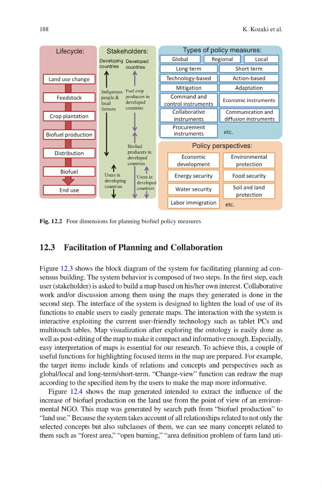
Fig. 12.2 Four dimensions for planning biofuel policy measures
K. Kozaki et al.
12.3 Facilitation of Planning and Collaboration
Figure 12.3 shows the block diagram of the system for facilitating planning ad consensus building. The system behavior is composed of two steps. In the first step, each
user (stakeholder) is asked to build a map based on his/her own interest. Collaborative
work and/or discussion among them using the maps they generated is done in the
second step. The interface of the system is designed to lighten the load of use of its
functions to enable users to easily generate maps. The interaction with the system is
interactive exploiting the current user-friendly technology such as tablet PCs and
multitouch tables. Map visualization after exploring the ontology is easily done as
well as post-editing of the map to make it compact and informative enough. Especially,
easy interpretation of maps is essential for our research. To achieve this, a couple of
useful functions for highlighting focused items in the map are prepared. For example,
the target items include kinds of relations and concepts and perspectives such as
global/local and long-term/short-term. “Change-view” function can redraw the map
according to the specified item by the users to make the map more informative.
Figure 12.4 shows the map generated intended to extract the influence of the
increase of biofuel production on the land use from the point of view of an environmental NGO. This map was generated by search path from “biofuel production” to
“land use.” Because the system takes account of all relationships related to not only the
selected concepts but also subclasses of them, we can see many concepts related to
them such as “forest area,” “open burning,” “area definition problem of farm land utiTypes of policy measures:
Land use change
Feedstock
Crop plantation
Biofuel production
Distribution
Biofuel
End use
Mitigation
Adaptation
Global
Regional
Local
Command and
control instruments
Economic instruments
Economic
development
Environmental
protection
Stakeholders:
Users in
developed
countries
Biofuel
producers in
developed
countries
Energy security
Food security
Users in
developing
countries
Fuel crop
producers in
developed
countries
Developed
countries
Developing
countries
Water security
Soil and land
protection
Policy perspectives:
Labor immigration etc.
Long term
Short term
Technology-based
Action-based
Lifecycle:
Indigenous
people &
local
farmers
Collaborative
instruments
Communication and
diffusion instruments
Procurement
instruments
etc.
Fig. 12.2 Four dimensions for planning biofuel policy measures
K. Kozaki et al.