

61
Urban areas are particularly well placed to utilize wireless technology, as there is
an increasing number of municipal wireless access points in urban areas, allowing
almost complete coverage in most towns and cities. Hence, with the appropriate
permissions granted, these existing municipal wireless networks (open access or
subscription wireless access points) can be utilized to relay data from sensors to the
host server.
Recently developments in the miniaturization of electronics have produced
advances in communications and computing power, with environmental sensors
becoming more innovative, reliable, compact, and inexpensive as a result. These
advances provide increased potential for urban networks of meteorological sensors,
which may now be more numerous and densely spaced, with vastly improved temporal collection and rapid data transmission (Muller et al. 2013). The new generation of atmospheric observation networks will permit new insights into urban
atmospheric processes.
The options available for powering sensor networks depend on the location of
the sensors, the specific power requirements, and the nature of equipment involved.
All short- and long-wave fluxes are affected by the special properties of the atmosphere and the surfaces of cities, and the same is true for the net all-wave radiation
balance that effectively drives the urban energy balance (Oke 1988). All of the
instruments of radiation measurements, their calibration, the data correction, and
most of the field methods are the same for urban environments as for open country
sites.
The calibration of equipment and instruments during intercomparison periods is
essential to ensure the quality of the data. Sensor networks frequently contain lowcost, nonstandard sensors, and as such all equipment needs to be tested against a
traceable “standard” instrument. Ideally, equipment should be calibrated at a
national standards and calibration lab, ensuring the reliability of results and allowing for comparisons with other equipment calibrated to the same standard.
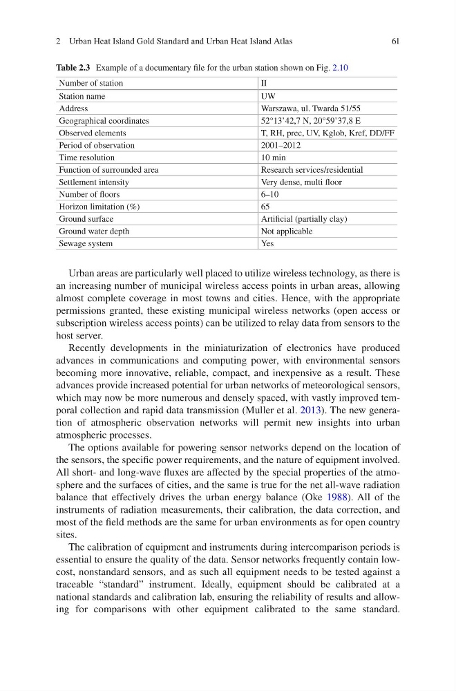
Table 2.3 Example of a documentary file for the urban station shown on Fig. 2.10
Number of station
II
Station name
UW
Address
Warszawa, ul. Twarda 51/55
Geographical coordinates
52°13’42,7 N, 20°59’37,8 E
Observed elements
T, RH, prec, UV, Kglob, Kref, DD/FF
Period of observation
2001–2012
Time resolution
10 min
Function of surrounded area
Research services/residential
Settlement intensity
Very dense, multi floor
Number of floors
6–10
Horizon limitation (%)
65
Ground surface
Artificial (partially clay)
Ground water depth
Not applicable
Sewage system
Yes
2 Urban Heat Island Gold Standard and Urban Heat Island Atlas
Urban areas are particularly well placed to utilize wireless technology, as there is
an increasing number of municipal wireless access points in urban areas, allowing
almost complete coverage in most towns and cities. Hence, with the appropriate
permissions granted, these existing municipal wireless networks (open access or
subscription wireless access points) can be utilized to relay data from sensors to the
host server.
Recently developments in the miniaturization of electronics have produced
advances in communications and computing power, with environmental sensors
becoming more innovative, reliable, compact, and inexpensive as a result. These
advances provide increased potential for urban networks of meteorological sensors,
which may now be more numerous and densely spaced, with vastly improved temporal collection and rapid data transmission (Muller et al. 2013). The new generation of atmospheric observation networks will permit new insights into urban
atmospheric processes.
The options available for powering sensor networks depend on the location of
the sensors, the specific power requirements, and the nature of equipment involved.
All short- and long-wave fluxes are affected by the special properties of the atmosphere and the surfaces of cities, and the same is true for the net all-wave radiation
balance that effectively drives the urban energy balance (Oke 1988). All of the
instruments of radiation measurements, their calibration, the data correction, and
most of the field methods are the same for urban environments as for open country
sites.
The calibration of equipment and instruments during intercomparison periods is
essential to ensure the quality of the data. Sensor networks frequently contain lowcost, nonstandard sensors, and as such all equipment needs to be tested against a
traceable “standard” instrument. Ideally, equipment should be calibrated at a
national standards and calibration lab, ensuring the reliability of results and allowing for comparisons with other equipment calibrated to the same standard.
Table 2.3 Example of a documentary file for the urban station shown on Fig. 2.10
Number of station
II
Station name
UW
Address
Warszawa, ul. Twarda 51/55
Geographical coordinates
52°13’42,7 N, 20°59’37,8 E
Observed elements
T, RH, prec, UV, Kglob, Kref, DD/FF
Period of observation
2001–2012
Time resolution
10 min
Function of surrounded area
Research services/residential
Settlement intensity
Very dense, multi floor
Number of floors
6–10
Horizon limitation (%)
65
Ground surface
Artificial (partially clay)
Ground water depth
Not applicable
Sewage system
Yes
2 Urban Heat Island Gold Standard and Urban Heat Island Atlas