

80
3.3 Materials and Methods
3.3.1 Study Area
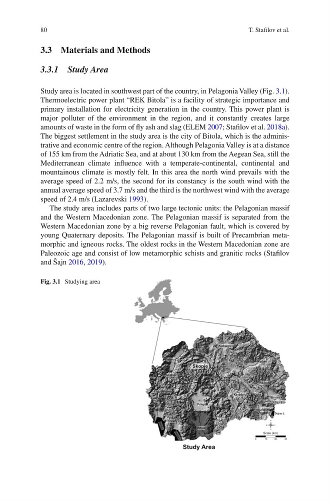
Study area is located in southwest part of the country, in Pelagonia Valley (Fig. 3.1).
Thermoelectric power plant “REK Bitola” is a facility of strategic importance and
primary installation for electricity generation in the country. This power plant is
major polluter of the environment in the region, and it constantly creates large
amounts of waste in the form of fly ash and slag (ELEM 2007; Stafilov et al. 2018a).
The biggest settlement in the study area is the city of Bitola, which is the administrative and economic centre of the region. Although Pelagonia Valley is at a distance
of 155 km from the Adriatic Sea, and at about 130 km from the Aegean Sea, still the
Mediterranean climate influence with a temperate-continental, continental and
mountainous climate is mostly felt. In this area the north wind prevails with the
average speed of 2.2 m/s, the second for its constancy is the south wind with the
annual average speed of 3.7 m/s and the third is the northwest wind with the average
speed of 2.4 m/s (Lazarevski 1993).
The study area includes parts of two large tectonic units: the Pelagonian massif
and the Western Macedonian zone. The Pelagonian massif is separated from the
Western Macedonian zone by a big reverse Pelagonian fault, which is covered by
young Quaternary deposits. The Pelagonian massif is built of Precambrian metamorphic and igneous rocks. The oldest rocks in the Western Macedonian zone are
Paleozoic age and consist of low metamorphic schists and granitic rocks (Stafilov
and Šajn 2016, 2019).
Fig. 3.1 Studying area
T. Stafilov et al.
3.3 Materials and Methods
3.3.1 Study Area
Study area is located in southwest part of the country, in Pelagonia Valley (Fig. 3.1).
Thermoelectric power plant “REK Bitola” is a facility of strategic importance and
primary installation for electricity generation in the country. This power plant is
major polluter of the environment in the region, and it constantly creates large
amounts of waste in the form of fly ash and slag (ELEM 2007; Stafilov et al. 2018a).
The biggest settlement in the study area is the city of Bitola, which is the administrative and economic centre of the region. Although Pelagonia Valley is at a distance
of 155 km from the Adriatic Sea, and at about 130 km from the Aegean Sea, still the
Mediterranean climate influence with a temperate-continental, continental and
mountainous climate is mostly felt. In this area the north wind prevails with the
average speed of 2.2 m/s, the second for its constancy is the south wind with the
annual average speed of 3.7 m/s and the third is the northwest wind with the average
speed of 2.4 m/s (Lazarevski 1993).
The study area includes parts of two large tectonic units: the Pelagonian massif
and the Western Macedonian zone. The Pelagonian massif is separated from the
Western Macedonian zone by a big reverse Pelagonian fault, which is covered by
young Quaternary deposits. The Pelagonian massif is built of Precambrian metamorphic and igneous rocks. The oldest rocks in the Western Macedonian zone are
Paleozoic age and consist of low metamorphic schists and granitic rocks (Stafilov
and Šajn 2016, 2019).
Fig. 3.1 Studying area
T. Stafilov et al.