

113
reagents – are most commonly used: NaClO 2 , KOH (50% solution), P (paraphenylenediamine) reagent, and Lugol’s solution.
4.4.1 Kuršumlija Town Case Study: Geoclimatic Features
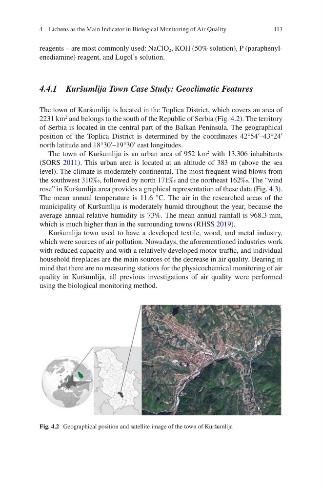
The town of Kuršumlija is located in the Toplica District, which covers an area of
2231 km
2
and belongs to the south of the Republic of Serbia (Fig. 4.2). The territory
of Serbia is located in the central part of the Balkan Peninsula. The geographical
position of the Toplica District is determined by the coordinates 42°54′–43°24′
north latitude and 18°30′–19°30′ east longitudes.
The town of Kuršumlija is an urban area of 952 km
2
with 13,306 inhabitants
(SORS 2011). This urban area is located at an altitude of 383 m (above the sea
level). The climate is moderately continental. The most frequent wind blows from
the southwest 310‰, followed by north 171‰ and the northeast 162‰. The “wind
rose” in Kuršumlija area provides a graphical representation of these data (Fig. 4.3).
The mean annual temperature is 11.6 °C. The air in the researched areas of the
municipality of Kuršumlija is moderately humid throughout the year, because the
average annual relative humidity is 73%. The mean annual rainfall is 968.3 mm,
which is much higher than in the surrounding towns (RHSS 2019).
Kuršumlija town used to have a developed textile, wood, and metal industry,
which were sources of air pollution. Nowadays, the aforementioned industries work
with reduced capacity and with a relatively developed motor traffic, and individual
household fireplaces are the main sources of the decrease in air quality. Bearing in
mind that there are no measuring stations for the physicochemical monitoring of air
quality in Kuršumlija, all previous investigations of air quality were performed
using the biological monitoring method.
Fig. 4.2 Geographical position and satellite image of the town of Kuršumlija
4 Lichens as the Main Indicator in Biological Monitoring of Air Quality
reagents – are most commonly used: NaClO 2 , KOH (50% solution), P (paraphenylenediamine) reagent, and Lugol’s solution.
4.4.1 Kuršumlija Town Case Study: Geoclimatic Features
The town of Kuršumlija is located in the Toplica District, which covers an area of
2231 km
2
and belongs to the south of the Republic of Serbia (Fig. 4.2). The territory
of Serbia is located in the central part of the Balkan Peninsula. The geographical
position of the Toplica District is determined by the coordinates 42°54′–43°24′
north latitude and 18°30′–19°30′ east longitudes.
The town of Kuršumlija is an urban area of 952 km
2
with 13,306 inhabitants
(SORS 2011). This urban area is located at an altitude of 383 m (above the sea
level). The climate is moderately continental. The most frequent wind blows from
the southwest 310‰, followed by north 171‰ and the northeast 162‰. The “wind
rose” in Kuršumlija area provides a graphical representation of these data (Fig. 4.3).
The mean annual temperature is 11.6 °C. The air in the researched areas of the
municipality of Kuršumlija is moderately humid throughout the year, because the
average annual relative humidity is 73%. The mean annual rainfall is 968.3 mm,
which is much higher than in the surrounding towns (RHSS 2019).
Kuršumlija town used to have a developed textile, wood, and metal industry,
which were sources of air pollution. Nowadays, the aforementioned industries work
with reduced capacity and with a relatively developed motor traffic, and individual
household fireplaces are the main sources of the decrease in air quality. Bearing in
mind that there are no measuring stations for the physicochemical monitoring of air
quality in Kuršumlija, all previous investigations of air quality were performed
using the biological monitoring method.
Fig. 4.2 Geographical position and satellite image of the town of Kuršumlija
4 Lichens as the Main Indicator in Biological Monitoring of Air Quality