

Geomorphology of Dakhla Depression
51
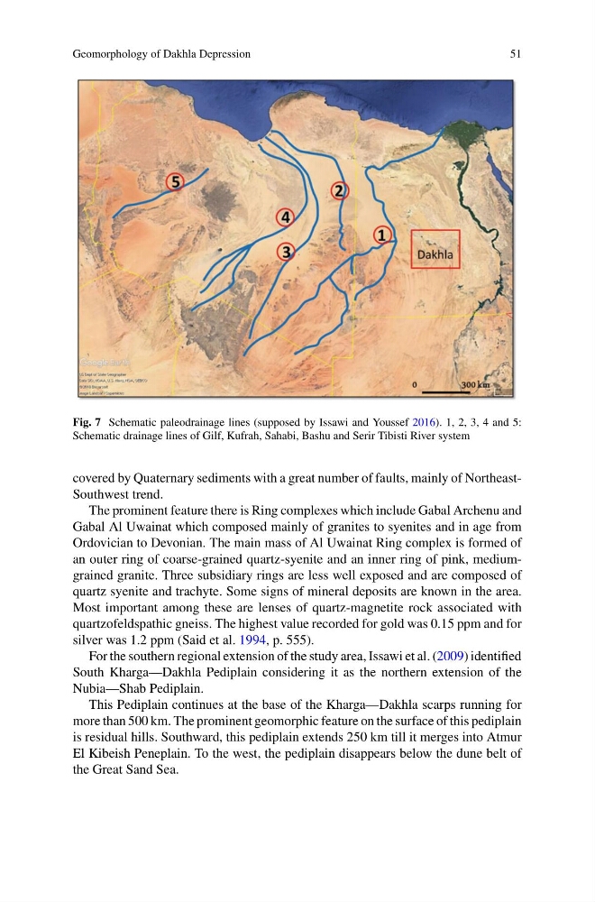
Fig. 7 Schematic paleodrainage lines (supposed by Issawi and Youssef 2016). 1, 2, 3, 4 and 5:
Schematic drainage lines of Gilf, Kufrah, Sahabi, Bashu and Serir Tibisti River system
covered by Quaternary sediments with a great number of faults, mainly of NortheastSouthwest trend.
The prominent feature there is Ring complexes which include Gabal Archenu and
Gabal Al Uwainat which composed mainly of granites to syenites and in age from
Ordovician to Devonian. The main mass of Al Uwainat Ring complex is formed of
an outer ring of coarse-grained quartz-syenite and an inner ring of pink, mediumgrained granite. Three subsidiary rings are less well exposed and are composed of
quartz syenite and trachyte. Some signs of mineral deposits are known in the area.
Most important among these are lenses of quartz-magnetite rock associated with
quartzofeldspathic gneiss. The highest value recorded for gold was 0.15 ppm and for
silver was 1.2 ppm (Said et al. 1994, p. 555).
For the southern regional extension of the study area, Issawi et al. (2009) identified
South Kharga—Dakhla Pediplain considering it as the northern extension of the
Nubia—Shab Pediplain.
This Pediplain continues at the base of the Kharga—Dakhla scarps running for
more than 500 km. The prominent geomorphic feature on the surface of this pediplain
is residual hills. Southward, this pediplain extends 250 km till it merges into Atmur
El Kibeish Peneplain. To the west, the pediplain disappears below the dune belt of
the Great Sand Sea.
51
Fig. 7 Schematic paleodrainage lines (supposed by Issawi and Youssef 2016). 1, 2, 3, 4 and 5:
Schematic drainage lines of Gilf, Kufrah, Sahabi, Bashu and Serir Tibisti River system
covered by Quaternary sediments with a great number of faults, mainly of NortheastSouthwest trend.
The prominent feature there is Ring complexes which include Gabal Archenu and
Gabal Al Uwainat which composed mainly of granites to syenites and in age from
Ordovician to Devonian. The main mass of Al Uwainat Ring complex is formed of
an outer ring of coarse-grained quartz-syenite and an inner ring of pink, mediumgrained granite. Three subsidiary rings are less well exposed and are composed of
quartz syenite and trachyte. Some signs of mineral deposits are known in the area.
Most important among these are lenses of quartz-magnetite rock associated with
quartzofeldspathic gneiss. The highest value recorded for gold was 0.15 ppm and for
silver was 1.2 ppm (Said et al. 1994, p. 555).
For the southern regional extension of the study area, Issawi et al. (2009) identified
South Kharga—Dakhla Pediplain considering it as the northern extension of the
Nubia—Shab Pediplain.
This Pediplain continues at the base of the Kharga—Dakhla scarps running for
more than 500 km. The prominent geomorphic feature on the surface of this pediplain
is residual hills. Southward, this pediplain extends 250 km till it merges into Atmur
El Kibeish Peneplain. To the west, the pediplain disappears below the dune belt of
the Great Sand Sea.