

248
E.-S. E. Omran
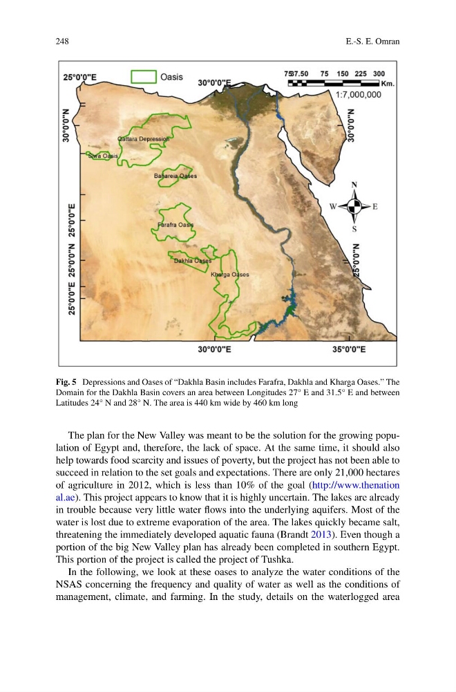
Fig. 5 Depressions and Oases of “Dakhla Basin includes Farafra, Dakhla and Kharga Oases.” The
Domain for the Dakhla Basin covers an area between Longitudes 27° E and 31.5° E and between
Latitudes 24° N and 28° N. The area is 440 km wide by 460 km long
The plan for the New Valley was meant to be the solution for the growing population of Egypt and, therefore, the lack of space. At the same time, it should also
help towards food scarcity and issues of poverty, but the project has not been able to
succeed in relation to the set goals and expectations. There are only 21,000 hectares
of agriculture in 2012, which is less than 10% of the goal (http://www.thenation
al.ae). This project appears to know that it is highly uncertain. The lakes are already
in trouble because very little water flows into the underlying aquifers. Most of the
water is lost due to extreme evaporation of the area. The lakes quickly became salt,
threatening the immediately developed aquatic fauna (Brandt 2013). Even though a
portion of the big New Valley plan has already been completed in southern Egypt.
This portion of the project is called the project of Tushka.
In the following, we look at these oases to analyze the water conditions of the
NSAS concerning the frequency and quality of water as well as the conditions of
management, climate, and farming. In the study, details on the waterlogged area
E.-S. E. Omran
Fig. 5 Depressions and Oases of “Dakhla Basin includes Farafra, Dakhla and Kharga Oases.” The
Domain for the Dakhla Basin covers an area between Longitudes 27° E and 31.5° E and between
Latitudes 24° N and 28° N. The area is 440 km wide by 460 km long
The plan for the New Valley was meant to be the solution for the growing population of Egypt and, therefore, the lack of space. At the same time, it should also
help towards food scarcity and issues of poverty, but the project has not been able to
succeed in relation to the set goals and expectations. There are only 21,000 hectares
of agriculture in 2012, which is less than 10% of the goal (http://www.thenation
al.ae). This project appears to know that it is highly uncertain. The lakes are already
in trouble because very little water flows into the underlying aquifers. Most of the
water is lost due to extreme evaporation of the area. The lakes quickly became salt,
threatening the immediately developed aquatic fauna (Brandt 2013). Even though a
portion of the big New Valley plan has already been completed in southern Egypt.
This portion of the project is called the project of Tushka.
In the following, we look at these oases to analyze the water conditions of the
NSAS concerning the frequency and quality of water as well as the conditions of
management, climate, and farming. In the study, details on the waterlogged area