

Development of Land Use and Groundwater …
221
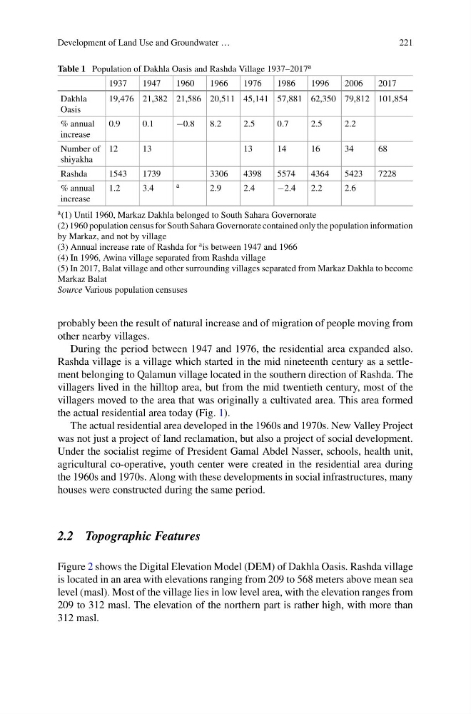
Table 1 Population of Dakhla Oasis and Rashda Village 1937–2017 a
1937
1947
1960
1966
1976
1986
1996
2006
2017
Dakhla
Oasis
19,476 21,382 21,586 20,511 45,141 57,881 62,350 79,812 101,854
% annual
increase
0.9
0.1
−0.8
8.2
2.5
0.7
2.5
2.2
Number of
shiyakha
12
13
13
14
16
34
68
Rashda
1543
1739
3306
4398
5574
4364
5423
7228
% annual
increase
1.2
3.4
a
2.9
2.4
−2.4
2.2
2.6
a (1) Until 1960, Markaz Dakhla belonged to South Sahara Governorate
(2) 1960 population census for South Sahara Governorate contained only the population information
by Markaz, and not by village
(3) Annual increase rate of Rashda for a is between 1947 and 1966
(4) In 1996, Awina village separated from Rashda village
(5) In 2017, Balat village and other surrounding villages separated from Markaz Dakhla to become
Markaz Balat
Source Various population censuses
probably been the result of natural increase and of migration of people moving from
other nearby villages.
During the period between 1947 and 1976, the residential area expanded also.
Rashda village is a village which started in the mid nineteenth century as a settlement belonging to Qalamun village located in the southern direction of Rashda. The
villagers lived in the hilltop area, but from the mid twentieth century, most of the
villagers moved to the area that was originally a cultivated area. This area formed
the actual residential area today (Fig. 1).
The actual residential area developed in the 1960s and 1970s. New Valley Project
was not just a project of land reclamation, but also a project of social development.
Under the socialist regime of President Gamal Abdel Nasser, schools, health unit,
agricultural co-operative, youth center were created in the residential area during
the 1960s and 1970s. Along with these developments in social infrastructures, many
houses were constructed during the same period.
2.2 Topographic Features
Figure 2 shows the Digital Elevation Model (DEM) of Dakhla Oasis. Rashda village
is located in an area with elevations ranging from 209 to 568 meters above mean sea
level (masl). Most of the village lies in low level area, with the elevation ranges from
209 to 312 masl. The elevation of the northern part is rather high, with more than
312 masl.
221
Table 1 Population of Dakhla Oasis and Rashda Village 1937–2017 a
1937
1947
1960
1966
1976
1986
1996
2006
2017
Dakhla
Oasis
19,476 21,382 21,586 20,511 45,141 57,881 62,350 79,812 101,854
% annual
increase
0.9
0.1
−0.8
8.2
2.5
0.7
2.5
2.2
Number of
shiyakha
12
13
13
14
16
34
68
Rashda
1543
1739
3306
4398
5574
4364
5423
7228
% annual
increase
1.2
3.4
a
2.9
2.4
−2.4
2.2
2.6
a (1) Until 1960, Markaz Dakhla belonged to South Sahara Governorate
(2) 1960 population census for South Sahara Governorate contained only the population information
by Markaz, and not by village
(3) Annual increase rate of Rashda for a is between 1947 and 1966
(4) In 1996, Awina village separated from Rashda village
(5) In 2017, Balat village and other surrounding villages separated from Markaz Dakhla to become
Markaz Balat
Source Various population censuses
probably been the result of natural increase and of migration of people moving from
other nearby villages.
During the period between 1947 and 1976, the residential area expanded also.
Rashda village is a village which started in the mid nineteenth century as a settlement belonging to Qalamun village located in the southern direction of Rashda. The
villagers lived in the hilltop area, but from the mid twentieth century, most of the
villagers moved to the area that was originally a cultivated area. This area formed
the actual residential area today (Fig. 1).
The actual residential area developed in the 1960s and 1970s. New Valley Project
was not just a project of land reclamation, but also a project of social development.
Under the socialist regime of President Gamal Abdel Nasser, schools, health unit,
agricultural co-operative, youth center were created in the residential area during
the 1960s and 1970s. Along with these developments in social infrastructures, many
houses were constructed during the same period.
2.2 Topographic Features
Figure 2 shows the Digital Elevation Model (DEM) of Dakhla Oasis. Rashda village
is located in an area with elevations ranging from 209 to 568 meters above mean sea
level (masl). Most of the village lies in low level area, with the elevation ranges from
209 to 312 masl. The elevation of the northern part is rather high, with more than
312 masl.