

124
The nominal spacing for vertical gas wells is one well per 40 acres (0.162 km
2
).
At the beginning of the shale gas revolution, George Mitchell started placing horizontal wells in the Barnett Shale at a spacing of 80 acres, but then quickly discovered that a wider spacing of 160 acres (0.647 km
2
) was more efficient. This spacing
became more-or-less standard during the development of many of the subsequent
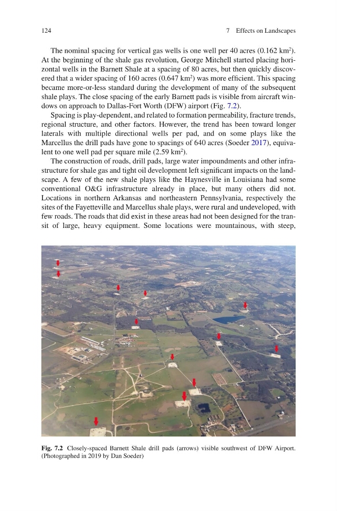
shale plays. The close spacing of the early Barnett pads is visible from aircraft windows on approach to Dallas-Fort Worth (DFW) airport (Fig. 7.2).
Spacing is play-dependent, and related to formation permeability, fracture trends,
regional structure, and other factors. However, the trend has been toward longer
laterals with multiple directional wells per pad, and on some plays like the
Marcellus the drill pads have gone to spacings of 640 acres (Soeder 2017), equivalent to one well pad per square mile (2.59 km
2
).
The construction of roads, drill pads, large water impoundments and other infrastructure for shale gas and tight oil development left significant impacts on the landscape. A few of the new shale plays like the Haynesville in Louisiana had some
conventional O&G infrastructure already in place, but many others did not.
Locations in northern Arkansas and northeastern Pennsylvania, respectively the
sites of the Fayetteville and Marcellus shale plays, were rural and undeveloped, with
few roads. The roads that did exist in these areas had not been designed for the transit of large, heavy equipment. Some locations were mountainous, with steep,
Fig. 7.2 Closely-spaced Barnett Shale drill pads (arrows) visible southwest of DFW Airport.
(Photographed in 2019 by Dan Soeder)
7 Effects on Landscapes
The nominal spacing for vertical gas wells is one well per 40 acres (0.162 km
2
).
At the beginning of the shale gas revolution, George Mitchell started placing horizontal wells in the Barnett Shale at a spacing of 80 acres, but then quickly discovered that a wider spacing of 160 acres (0.647 km
2
) was more efficient. This spacing
became more-or-less standard during the development of many of the subsequent
shale plays. The close spacing of the early Barnett pads is visible from aircraft windows on approach to Dallas-Fort Worth (DFW) airport (Fig. 7.2).
Spacing is play-dependent, and related to formation permeability, fracture trends,
regional structure, and other factors. However, the trend has been toward longer
laterals with multiple directional wells per pad, and on some plays like the
Marcellus the drill pads have gone to spacings of 640 acres (Soeder 2017), equivalent to one well pad per square mile (2.59 km
2
).
The construction of roads, drill pads, large water impoundments and other infrastructure for shale gas and tight oil development left significant impacts on the landscape. A few of the new shale plays like the Haynesville in Louisiana had some
conventional O&G infrastructure already in place, but many others did not.
Locations in northern Arkansas and northeastern Pennsylvania, respectively the
sites of the Fayetteville and Marcellus shale plays, were rural and undeveloped, with
few roads. The roads that did exist in these areas had not been designed for the transit of large, heavy equipment. Some locations were mountainous, with steep,
Fig. 7.2 Closely-spaced Barnett Shale drill pads (arrows) visible southwest of DFW Airport.
(Photographed in 2019 by Dan Soeder)
7 Effects on Landscapes