

30
P. Muñoz et al.
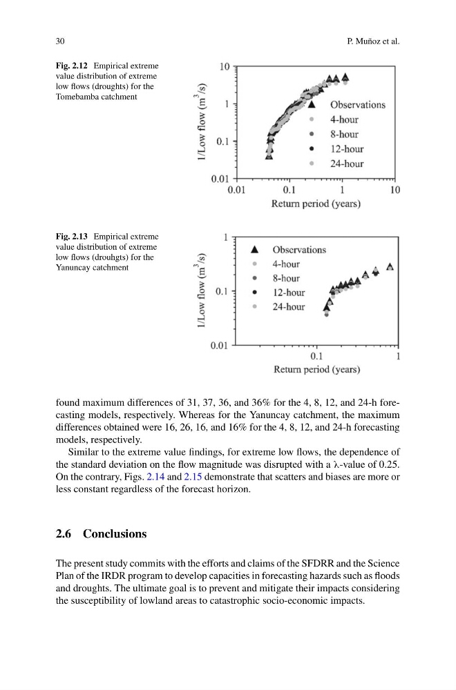
Fig. 2.12 Empirical extreme
value distribution of extreme
low flows (droughts) for the
Tomebamba catchment
Fig. 2.13 Empirical extreme
value distribution of extreme
low flows (drouhgts) for the
Yanuncay catchment
found maximum differences of 31, 37, 36, and 36% for the 4, 8, 12, and 24-h forecasting models, respectively. Whereas for the Yanuncay catchment, the maximum
differences obtained were 16, 26, 16, and 16% for the 4, 8, 12, and 24-h forecasting
models, respectively.
Similar to the extreme value findings, for extreme low flows, the dependence of
the standard deviation on the flow magnitude was disrupted with a λ-value of 0.25.
On the contrary, Figs. 2.14 and 2.15 demonstrate that scatters and biases are more or
less constant regardless of the forecast horizon.
2.6 Conclusions
The present study commits with the efforts and claims of the SFDRR and the Science
Plan of the IRDR program to develop capacities in forecasting hazards such as floods
and droughts. The ultimate goal is to prevent and mitigate their impacts considering
the susceptibility of lowland areas to catastrophic socio-economic impacts.
P. Muñoz et al.
Fig. 2.12 Empirical extreme
value distribution of extreme
low flows (droughts) for the
Tomebamba catchment
Fig. 2.13 Empirical extreme
value distribution of extreme
low flows (drouhgts) for the
Yanuncay catchment
found maximum differences of 31, 37, 36, and 36% for the 4, 8, 12, and 24-h forecasting models, respectively. Whereas for the Yanuncay catchment, the maximum
differences obtained were 16, 26, 16, and 16% for the 4, 8, 12, and 24-h forecasting
models, respectively.
Similar to the extreme value findings, for extreme low flows, the dependence of
the standard deviation on the flow magnitude was disrupted with a λ-value of 0.25.
On the contrary, Figs. 2.14 and 2.15 demonstrate that scatters and biases are more or
less constant regardless of the forecast horizon.
2.6 Conclusions
The present study commits with the efforts and claims of the SFDRR and the Science
Plan of the IRDR program to develop capacities in forecasting hazards such as floods
and droughts. The ultimate goal is to prevent and mitigate their impacts considering
the susceptibility of lowland areas to catastrophic socio-economic impacts.