

different geological materials carried by water, the intensity
of the surface runoff, and the topography of the valley.
Fluvents are mostly brownish to reddish soils that are formed
in old or recent water deposited sediments. The ages of these
layers differ from one soil to another, and can even differ
within the same soil, and are often interspersed with layers
deposited by wind. Sometimes these soils are buried under a
shallow layer of clear sand deposited by active wind erosion.
The most important characteristics that unite most of the
soils of different sedimentary valleys are their dark color,
which is often a dark brown, as well as their heavy, often
clayey-loamy texture and varying proportions of gravel. The
degree of reaction in these soils tends to be alkaline. The
percentage of salinity in it varies from one soil to another,
and is often from simple to medium, as it contains varying
amounts of calcium carbonate and gypsum. The fertility
status of these soils is, like other soils in dry areas, poor in
organic matter and some nutrients, especially nitrogen and
phosphorus. These soils are classified under the great group
level in Libya, according to the dominant Moisture Regime
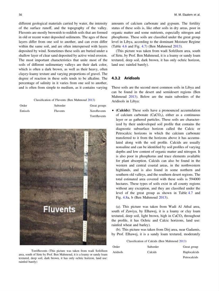
(Table 4.6 and Fig. 4.7) (Ben Mahmoud 2013).
(This picture was taken from wadi SofelJeen area, south
of Sirte, by Prof. Ben Mahmoud, it is a loamy or sandy loam
textured, deep soil, dark brown, it has only ochric horizon,
land use: rainfed barely).
4.3.2 Aridisols
These soils are the second most common soils in Libya and
can be found in the desert and semidesert regions (Ben
Mahmoud 2013). Below are the main suborders of the
Aridisols in Libya:
• (Calcids): These soils have a pronounced accumulation
of calcium carbonate (CaCO 3 ), either as a continuous
layer or as gathered particles. These soils are characterized by their undeveloped soil profile that contains the
diagnostic subsurface horizon called the Calcic or
Petrocalcic horizons in which the calcium carbonate
transferred to it from the horizons above it has accumulated along with the soil profile. Calcids are usually
nonsaline and can be identified by soil profiles of varying
depths and low content of organic matter and nitrogen. It
is also poor in phosphorus and trace elements available
for plant absorption. Calcids can also be found in the
western and central coastal areas, in the northwestern
highlands, and is also found in some northern and
southern old valleys, and the southern desert regions. The
total estimated area covered with these soils is 594000
hectares. These types of soils exist in all county regions
without any exception, and they are classified under the
level of the great group as shown in Table 4.7 and
Fig. 4.8a, b (Ben Mahmoud 2013).
(a). This picture was taken from Wadi Al Athal area,
south of Zawiya, by Elhawej, it is a loamy or clay loam
textured, deep soil, light brown, high in CaCO 3 throughout
the profile, it has Ochric and Calcic horizons, land use:
rainfed wheat and barley).
(b). This picture was taken from Dirj area, near Gadamis,
by Prof. Elhawej, it is a sandy loam textured, moderately
Table 4.6 Classification of Fluvents (Ben Mahmoud 2013)
Order
Suborder
Great groups
Entisols
Fluvents
Xerofluvents
Torrifluvents
Fig. 4.7 Torrifluvents (This picture was taken from wadi SofelJeen
area, south of Sirte by Prof. Ben Mahmoud, it is a loamy or sandy loam
textured, deep soil, dark brown, it has only ochric horizon, land use:
rainfed barely)
Table 4.7 Classification of Calcids (Ben Mahmoud 2013)
Order
Suborder
Great group
Aridsols
Calcids
Haplocalcids
Petrocalcids
56
M. M. Elaalem et al.
of the surface runoff, and the topography of the valley.
Fluvents are mostly brownish to reddish soils that are formed
in old or recent water deposited sediments. The ages of these
layers differ from one soil to another, and can even differ
within the same soil, and are often interspersed with layers
deposited by wind. Sometimes these soils are buried under a
shallow layer of clear sand deposited by active wind erosion.
The most important characteristics that unite most of the
soils of different sedimentary valleys are their dark color,
which is often a dark brown, as well as their heavy, often
clayey-loamy texture and varying proportions of gravel. The
degree of reaction in these soils tends to be alkaline. The
percentage of salinity in it varies from one soil to another,
and is often from simple to medium, as it contains varying
amounts of calcium carbonate and gypsum. The fertility
status of these soils is, like other soils in dry areas, poor in
organic matter and some nutrients, especially nitrogen and
phosphorus. These soils are classified under the great group
level in Libya, according to the dominant Moisture Regime
(Table 4.6 and Fig. 4.7) (Ben Mahmoud 2013).
(This picture was taken from wadi SofelJeen area, south
of Sirte, by Prof. Ben Mahmoud, it is a loamy or sandy loam
textured, deep soil, dark brown, it has only ochric horizon,
land use: rainfed barely).
4.3.2 Aridisols
These soils are the second most common soils in Libya and
can be found in the desert and semidesert regions (Ben
Mahmoud 2013). Below are the main suborders of the
Aridisols in Libya:
• (Calcids): These soils have a pronounced accumulation
of calcium carbonate (CaCO 3 ), either as a continuous
layer or as gathered particles. These soils are characterized by their undeveloped soil profile that contains the
diagnostic subsurface horizon called the Calcic or
Petrocalcic horizons in which the calcium carbonate
transferred to it from the horizons above it has accumulated along with the soil profile. Calcids are usually
nonsaline and can be identified by soil profiles of varying
depths and low content of organic matter and nitrogen. It
is also poor in phosphorus and trace elements available
for plant absorption. Calcids can also be found in the
western and central coastal areas, in the northwestern
highlands, and is also found in some northern and
southern old valleys, and the southern desert regions. The
total estimated area covered with these soils is 594000
hectares. These types of soils exist in all county regions
without any exception, and they are classified under the
level of the great group as shown in Table 4.7 and
Fig. 4.8a, b (Ben Mahmoud 2013).
(a). This picture was taken from Wadi Al Athal area,
south of Zawiya, by Elhawej, it is a loamy or clay loam
textured, deep soil, light brown, high in CaCO 3 throughout
the profile, it has Ochric and Calcic horizons, land use:
rainfed wheat and barley).
(b). This picture was taken from Dirj area, near Gadamis,
by Prof. Elhawej, it is a sandy loam textured, moderately
Table 4.6 Classification of Fluvents (Ben Mahmoud 2013)
Order
Suborder
Great groups
Entisols
Fluvents
Xerofluvents
Torrifluvents
Fig. 4.7 Torrifluvents (This picture was taken from wadi SofelJeen
area, south of Sirte by Prof. Ben Mahmoud, it is a loamy or sandy loam
textured, deep soil, dark brown, it has only ochric horizon, land use:
rainfed barely)
Table 4.7 Classification of Calcids (Ben Mahmoud 2013)
Order
Suborder
Great group
Aridsols
Calcids
Haplocalcids
Petrocalcids
56
M. M. Elaalem et al.