

surface, a plant covering that reduces the wind speed on the
surface is necessary.
In Japan, from the latter half of the 1960s, the mineralogy
of “Kosa” (“yellow sand” in Japanese) which is transported
from March to May, in the early spring, has been examined.
Inoue (1981) found that Kosa is mainly composed of quartz,
feldspar and illite and had a similar mineral composition to
that of “loess” distributed in China. Additionally, from
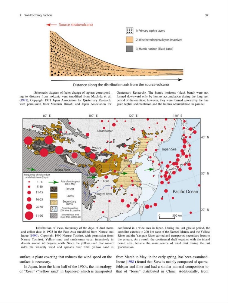
Fig. 2.24 Schematic diagram of facies change of tephras corresponding to distance from volcanic vent (modified from Machida et al.
(1971), Copyright 1971 Japan Association for Quaternary Research,
with permission from Machida Hiroshi and Japan Association for
Quaternary Research). The humic horizons (black band) were not
formed downward only by humus accumulation during the long rest
period of the eruption; however, they were formed upward by the fine
grain tephra sedimentation and the humus accumulation in parallel
Fig. 2.25 Distribution of loess, frequency of the days of dust storm
and eolian dust in 1975 in the East Asia (modified from Naruse and
Inoue (1990), Copyright 1990 Naruse Toshiro, with permission from
Naruse Toshiro). Yellow sand and sandstorms occur intensively in
deserts around 40 degrees north. Since the yellow sand that soared
rides the westerly wind and spreads over time, yellow sand is
confirmed in a wide area in Japan. During the last glacial period, the
coastline extends to 200 km west of the Nansei Islands, and the Yellow
River and the Yangtze River carried and transported secondary loess to
the estuary. As a result, the continental shelf together with the inland
desert area, became the main source of wind dust during the last
glaciatiation
2 Soil-Forming Factors
37
surface is necessary.
In Japan, from the latter half of the 1960s, the mineralogy
of “Kosa” (“yellow sand” in Japanese) which is transported
from March to May, in the early spring, has been examined.
Inoue (1981) found that Kosa is mainly composed of quartz,
feldspar and illite and had a similar mineral composition to
that of “loess” distributed in China. Additionally, from
Fig. 2.24 Schematic diagram of facies change of tephras corresponding to distance from volcanic vent (modified from Machida et al.
(1971), Copyright 1971 Japan Association for Quaternary Research,
with permission from Machida Hiroshi and Japan Association for
Quaternary Research). The humic horizons (black band) were not
formed downward only by humus accumulation during the long rest
period of the eruption; however, they were formed upward by the fine
grain tephra sedimentation and the humus accumulation in parallel
Fig. 2.25 Distribution of loess, frequency of the days of dust storm
and eolian dust in 1975 in the East Asia (modified from Naruse and
Inoue (1990), Copyright 1990 Naruse Toshiro, with permission from
Naruse Toshiro). Yellow sand and sandstorms occur intensively in
deserts around 40 degrees north. Since the yellow sand that soared
rides the westerly wind and spreads over time, yellow sand is
confirmed in a wide area in Japan. During the last glacial period, the
coastline extends to 200 km west of the Nansei Islands, and the Yellow
River and the Yangtze River carried and transported secondary loess to
the estuary. As a result, the continental shelf together with the inland
desert area, became the main source of wind dust during the last
glaciatiation
2 Soil-Forming Factors
37