

plains and basins are only located in the Kinki triangle zone.
However, small basins and lowlands along rivers occur
throughout mountains in the inner zone, as described previously. There is a long history of human activity in the
Kinki triangle, Setouchi region, and these mountain lowlands have long been used as paddy fields. This historical
background may have affected the distribution of Fluvic
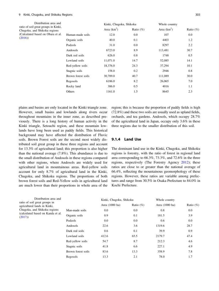
soils. Brown Forest soils are the second most widely distributed soil great group in these three regions and account
for 13.3% of agricultural land; this proportion is also higher
than the national average (7.8%). This abundance is due to
the small distribution of Andosols in these regions compared
with other regions, where Andosols are widely used for
agricultural land in mountainous areas. Red-yellow soils
account for only 8.7% of agricultural land in the Kinki,
Chugoku, and Shikoku regions. The proportions of both
brown forest soils and Red-Yellow soils in agricultural land
are much lower than their proportions in whole area of the
region; this is because the proportion of paddy fields is high
(72.8%) and these two soils are usually used as upland fields,
orchards, and tea gardens. Andosols, which occupy 28.7%
of the agricultural land in Japan, occupy only 3.6% in these
three regions due to the smaller distribution of this soil.
9.1.4 Land Use
The dominant land use in the Kinki, Chugoku, and Shikoku
regions is forestry, with the ratio of forest in regional land
area corresponding to 66.3%, 73.3%, and 72.6% in the three
regions, respectively (The Forestry Agency 2012); these
ratios are close to or greater than the national average of
66.4%, reflecting the mountainous geomorphology of these
regions. However, these ratios are variable among prefectures and range from 30.5% in Osaka Prefecture to 84.0% in
Kochi Prefecture.
Table 9.1 Distribution area and
ratio of soil great groups in Kinki,
Chugoku, and Shikoku regions
(Calculated based on Obara et al.
(2016))
Kinki, Chugoku, Shikoku
Whole country
Area (km
2
)
Ratio (%)
Area (km
2
)
Ratio (%)
Human-made soils
12.0
0.0
107
0.0
Organic soils
40.0
0.1
4403
1.2
Podzols
31.0
0.0
8297
2.2
Andosols
6723.0
8.9
113,481
30.7
Dark red soils
626.0
0.8
1748
0.5
Lowland soils
11,071.0
14.7
52,085
14.1
Red-yellow soils
18,376.0
24.3
37,294
10.1
Stagnic soils
158.0
0.2
2946
0.8
Brown forest soils
30,789.0
40.7
111,089
30.0
Regosols
6186.0
8.2
26,065
7.0
Rocky land
386.0
0.5
4016
1.1
Others
1161.0
1.5
8645
2.3
Table 9.2 Distribution area and
ratio of soil great groups in
agricultural lands in Kinki,
Chugoku, and Shikoku regions
(calculated based on Kanda et al.
(2017))
Kinki, Chugoku, Shikoku
Whole country
Area (1000 ha)
Ratio (%)
Area (1000 ha)
Ratio (%)
Man-made soils
0.0
0.0
0.8
0.0
Organic soils
0.9
0.1
181.5
3.9
Podzols
0.0
0.0
0.6
0.0
Andosols
22.6
3.6
1319.6
28.7
Dark red soils
0.6
0.1
39.9
0.9
Lowland soils
412.6
65.5
2179.7
47.4
Red-yellow soils
54.7
8.7
212.3
4.6
Stagnic soils
41.8
6.6
227.1
4.9
Brown forest soils
83.6
13.3
358.9
7.8
Regosols
13.3
2.1
78.0
1.7
9 Kinki, Chugoku, and Shikoku Regions
303
However, small basins and lowlands along rivers occur
throughout mountains in the inner zone, as described previously. There is a long history of human activity in the
Kinki triangle, Setouchi region, and these mountain lowlands have long been used as paddy fields. This historical
background may have affected the distribution of Fluvic
soils. Brown Forest soils are the second most widely distributed soil great group in these three regions and account
for 13.3% of agricultural land; this proportion is also higher
than the national average (7.8%). This abundance is due to
the small distribution of Andosols in these regions compared
with other regions, where Andosols are widely used for
agricultural land in mountainous areas. Red-yellow soils
account for only 8.7% of agricultural land in the Kinki,
Chugoku, and Shikoku regions. The proportions of both
brown forest soils and Red-Yellow soils in agricultural land
are much lower than their proportions in whole area of the
region; this is because the proportion of paddy fields is high
(72.8%) and these two soils are usually used as upland fields,
orchards, and tea gardens. Andosols, which occupy 28.7%
of the agricultural land in Japan, occupy only 3.6% in these
three regions due to the smaller distribution of this soil.
9.1.4 Land Use
The dominant land use in the Kinki, Chugoku, and Shikoku
regions is forestry, with the ratio of forest in regional land
area corresponding to 66.3%, 73.3%, and 72.6% in the three
regions, respectively (The Forestry Agency 2012); these
ratios are close to or greater than the national average of
66.4%, reflecting the mountainous geomorphology of these
regions. However, these ratios are variable among prefectures and range from 30.5% in Osaka Prefecture to 84.0% in
Kochi Prefecture.
Table 9.1 Distribution area and
ratio of soil great groups in Kinki,
Chugoku, and Shikoku regions
(Calculated based on Obara et al.
(2016))
Kinki, Chugoku, Shikoku
Whole country
Area (km
2
)
Ratio (%)
Area (km
2
)
Ratio (%)
Human-made soils
12.0
0.0
107
0.0
Organic soils
40.0
0.1
4403
1.2
Podzols
31.0
0.0
8297
2.2
Andosols
6723.0
8.9
113,481
30.7
Dark red soils
626.0
0.8
1748
0.5
Lowland soils
11,071.0
14.7
52,085
14.1
Red-yellow soils
18,376.0
24.3
37,294
10.1
Stagnic soils
158.0
0.2
2946
0.8
Brown forest soils
30,789.0
40.7
111,089
30.0
Regosols
6186.0
8.2
26,065
7.0
Rocky land
386.0
0.5
4016
1.1
Others
1161.0
1.5
8645
2.3
Table 9.2 Distribution area and
ratio of soil great groups in
agricultural lands in Kinki,
Chugoku, and Shikoku regions
(calculated based on Kanda et al.
(2017))
Kinki, Chugoku, Shikoku
Whole country
Area (1000 ha)
Ratio (%)
Area (1000 ha)
Ratio (%)
Man-made soils
0.0
0.0
0.8
0.0
Organic soils
0.9
0.1
181.5
3.9
Podzols
0.0
0.0
0.6
0.0
Andosols
22.6
3.6
1319.6
28.7
Dark red soils
0.6
0.1
39.9
0.9
Lowland soils
412.6
65.5
2179.7
47.4
Red-yellow soils
54.7
8.7
212.3
4.6
Stagnic soils
41.8
6.6
227.1
4.9
Brown forest soils
83.6
13.3
358.9
7.8
Regosols
13.3
2.1
78.0
1.7
9 Kinki, Chugoku, and Shikoku Regions
303