

east to west. In the southern backbone range, the Kibi plateau (3) extends from the west of Hyogo Prefecture to Hiroshima Prefecture, with an average elevation of 400–600 m
a.s.l. In the north of the backbone range, the Suou-Iwami
plateau (4) extends from Shimane Prefecture to Yamaguchi
Prefecture, and the average elevation of this plateau is
slightly lower than the Kibi plateau. Several relatively wide
basins, including the Fukuchiyama (5), Tsuyama (6), and
Miyoshi basins (7), along with a number of small basins and
lowlands along rivers are located in the Tanba and Chugoku
mountains. In this region, a small number of volcanoes were
active in the Quaternary Period. Of these, only Mt. Daisen
(8) and Mt. Sanbe (9) released abundant tephra (Machida
and Arai 1992); the others are small groups of volcanoes
located in the Chugoku and Tanba mountains (Machida
2004). Along the coast of the Sea of Japan in the north of the
Chugoku mountains, relatively wide alluvial plains, including the Tottori (10) and Yonago (11) plains, are distributed
from Tottori Prefecture to the Shimane Peninsula. The area
of these plains has been expanded by land reclamation and
the sedimentation of deposit soils from the Chugoku
mountains, where iron sand was collected from the sixteenth
to nineteenth centuries. In the west of the Shimane Peninsula, only a few small alluvial plains are distributed.
Mountains in the outer zone consist of the Kii mountains
(12) in the south of the Kii Peninsula and the Shikoku
mountains (13) on Shikoku Island. The average elevation of
the Kii mountains is 1000–1100 m a.s.l., and that of the
Shikoku mountains is 1300–1400 m a.s.l. The central parts
of both mountain ranges reach about 2000 m a.s.l. Mountain
relief is steep and valleys are deep. In the coastal regions of
these mountain ranges, marine terraces are developed and ria
coasts are distributed (Ota 2004). Therefore, alluvial plains
are limited around these mountains, with the only relatively
large plains being the Wakayama (14) and Tokushima
(15) plains along the MTL and the Kochi plain (16) in the
south of Shikoku Island.
The Setouchi region is a lowland region between the
Chugoku mountains and the MTL and is divided into the
Chugoku and Shikoku regions by the Seto Inland Sea (Setonaikai). In the coast of the Chugoku region, the Okayama
plain (17) and other smaller alluvial plains are located from
the west of Hyogo Prefecture to the east of Yamaguchi
Prefecture. Most of these plains have tidal flats, since tidal
currents are gentle and tidal ranges are large. The areas of
these plains were expanded by human activities from the
sixteenth to the nineteenth centuries, such as the sedimentation of deposits from iron sand collections in the Chugoku
mountains and land reclamation for salt production and
paddy fields (Naruse 2004). In the Shikoku region side, the
Sanuki mountains (18) in Kagawa Prefecture and the
Takanawa mountains (19) in Ehime Prefecture are located to
the north of the MTL. The highest elevations of these
mountains are about 1000 m a.s.l. Small plains such as the
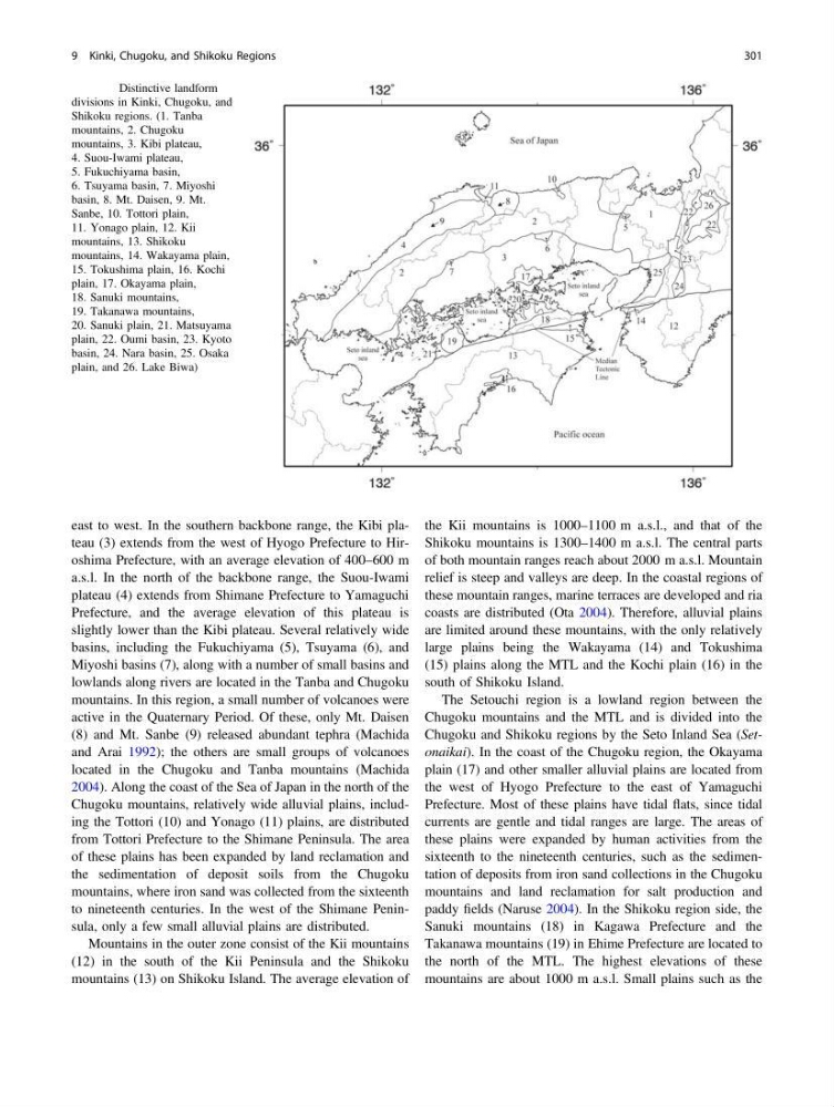
Fig. 9.1 Distinctive landform
divisions in Kinki, Chugoku, and
Shikoku regions. (1. Tanba
mountains, 2. Chugoku
mountains, 3. Kibi plateau,
4. Suou-Iwami plateau,
5. Fukuchiyama basin,
6. Tsuyama basin, 7. Miyoshi
basin, 8. Mt. Daisen, 9. Mt.
Sanbe, 10. Tottori plain,
11. Yonago plain, 12. Kii
mountains, 13. Shikoku
mountains, 14. Wakayama plain,
15. Tokushima plain, 16. Kochi
plain, 17. Okayama plain,
18. Sanuki mountains,
19. Takanawa mountains,
20. Sanuki plain, 21. Matsuyama
plain, 22. Oumi basin, 23. Kyoto
basin, 24. Nara basin, 25. Osaka
plain, and 26. Lake Biwa)
9 Kinki, Chugoku, and Shikoku Regions
301
a.s.l. In the north of the backbone range, the Suou-Iwami
plateau (4) extends from Shimane Prefecture to Yamaguchi
Prefecture, and the average elevation of this plateau is
slightly lower than the Kibi plateau. Several relatively wide
basins, including the Fukuchiyama (5), Tsuyama (6), and
Miyoshi basins (7), along with a number of small basins and
lowlands along rivers are located in the Tanba and Chugoku
mountains. In this region, a small number of volcanoes were
active in the Quaternary Period. Of these, only Mt. Daisen
(8) and Mt. Sanbe (9) released abundant tephra (Machida
and Arai 1992); the others are small groups of volcanoes
located in the Chugoku and Tanba mountains (Machida
2004). Along the coast of the Sea of Japan in the north of the
Chugoku mountains, relatively wide alluvial plains, including the Tottori (10) and Yonago (11) plains, are distributed
from Tottori Prefecture to the Shimane Peninsula. The area
of these plains has been expanded by land reclamation and
the sedimentation of deposit soils from the Chugoku
mountains, where iron sand was collected from the sixteenth
to nineteenth centuries. In the west of the Shimane Peninsula, only a few small alluvial plains are distributed.
Mountains in the outer zone consist of the Kii mountains
(12) in the south of the Kii Peninsula and the Shikoku
mountains (13) on Shikoku Island. The average elevation of
the Kii mountains is 1000–1100 m a.s.l., and that of the
Shikoku mountains is 1300–1400 m a.s.l. The central parts
of both mountain ranges reach about 2000 m a.s.l. Mountain
relief is steep and valleys are deep. In the coastal regions of
these mountain ranges, marine terraces are developed and ria
coasts are distributed (Ota 2004). Therefore, alluvial plains
are limited around these mountains, with the only relatively
large plains being the Wakayama (14) and Tokushima
(15) plains along the MTL and the Kochi plain (16) in the
south of Shikoku Island.
The Setouchi region is a lowland region between the
Chugoku mountains and the MTL and is divided into the
Chugoku and Shikoku regions by the Seto Inland Sea (Setonaikai). In the coast of the Chugoku region, the Okayama
plain (17) and other smaller alluvial plains are located from
the west of Hyogo Prefecture to the east of Yamaguchi
Prefecture. Most of these plains have tidal flats, since tidal
currents are gentle and tidal ranges are large. The areas of
these plains were expanded by human activities from the
sixteenth to the nineteenth centuries, such as the sedimentation of deposits from iron sand collections in the Chugoku
mountains and land reclamation for salt production and
paddy fields (Naruse 2004). In the Shikoku region side, the
Sanuki mountains (18) in Kagawa Prefecture and the
Takanawa mountains (19) in Ehime Prefecture are located to
the north of the MTL. The highest elevations of these
mountains are about 1000 m a.s.l. Small plains such as the
Fig. 9.1 Distinctive landform
divisions in Kinki, Chugoku, and
Shikoku regions. (1. Tanba
mountains, 2. Chugoku
mountains, 3. Kibi plateau,
4. Suou-Iwami plateau,
5. Fukuchiyama basin,
6. Tsuyama basin, 7. Miyoshi
basin, 8. Mt. Daisen, 9. Mt.
Sanbe, 10. Tottori plain,
11. Yonago plain, 12. Kii
mountains, 13. Shikoku
mountains, 14. Wakayama plain,
15. Tokushima plain, 16. Kochi
plain, 17. Okayama plain,
18. Sanuki mountains,
19. Takanawa mountains,
20. Sanuki plain, 21. Matsuyama
plain, 22. Oumi basin, 23. Kyoto
basin, 24. Nara basin, 25. Osaka
plain, and 26. Lake Biwa)
9 Kinki, Chugoku, and Shikoku Regions
301