

due South corresponds to 0° and is counted westward, the angles then are between −180°
and 180°. In this book we will use the convention where A = 0° corresponds to due North.
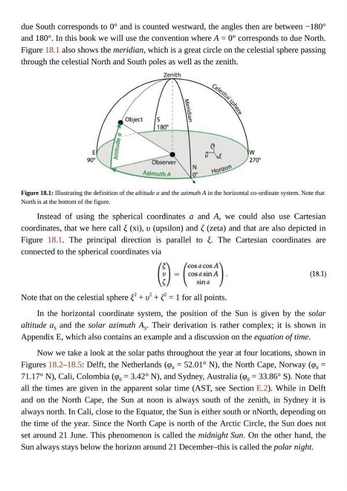
Figure 18.1 also shows the meridian, which is a great circle on the celestial sphere passing
through the celestial North and South poles as well as the zenith.
Figure 18.1: Illustrating the definition of the altitude a and the azimuth A in the horizontal co-ordinate system. Note that
North is at the bottom of the figure.
Instead of using the spherical coordinates a and A, we could also use Cartesian
coordinates, that we here call ξ (xi), υ (upsilon) and ζ (zeta) and that are also depicted in
Figure 18.1. The principal direction is parallel to ξ. The Cartesian coordinates are
connected to the spherical coordinates via
Note that on the celestial sphere ξ
2 + υ
2
+ ζ
2 = 1 for all points.
In the horizontal coordinate system, the position of the Sun is given by the solar
altitude a S and the solar azimuth A S . Their derivation is rather complex; it is shown in
Appendix E, which also contains an example and a discussion on the equation of time.
Now we take a look at the solar paths throughout the year at four locations, shown in
Figures 18.2–18.5: Delft, the Netherlands (φ 0 = 52.01° N), the North Cape, Norway (φ 0 =
71.17° N), Cali, Colombia (φ 0 = 3.42° N), and Sydney, Australia (φ 0 = 33.86° S). Note that
all the times are given in the apparent solar time (AST, see Section E.2). While in Delft
and on the North Cape, the Sun at noon is always south of the zenith, in Sydney it is
always north. In Cali, close to the Equator, the Sun is either south or nNorth, depending on
the time of the year. Since the North Cape is north of the Arctic Circle, the Sun does not
set around 21 June. This phenomenon is called the midnight Sun. On the other hand, the
Sun always stays below the horizon around 21 December–this is called the polar night.
and 180°. In this book we will use the convention where A = 0° corresponds to due North.
Figure 18.1 also shows the meridian, which is a great circle on the celestial sphere passing
through the celestial North and South poles as well as the zenith.
Figure 18.1: Illustrating the definition of the altitude a and the azimuth A in the horizontal co-ordinate system. Note that
North is at the bottom of the figure.
Instead of using the spherical coordinates a and A, we could also use Cartesian
coordinates, that we here call ξ (xi), υ (upsilon) and ζ (zeta) and that are also depicted in
Figure 18.1. The principal direction is parallel to ξ. The Cartesian coordinates are
connected to the spherical coordinates via
Note that on the celestial sphere ξ
2 + υ
2
+ ζ
2 = 1 for all points.
In the horizontal coordinate system, the position of the Sun is given by the solar
altitude a S and the solar azimuth A S . Their derivation is rather complex; it is shown in
Appendix E, which also contains an example and a discussion on the equation of time.
Now we take a look at the solar paths throughout the year at four locations, shown in
Figures 18.2–18.5: Delft, the Netherlands (φ 0 = 52.01° N), the North Cape, Norway (φ 0 =
71.17° N), Cali, Colombia (φ 0 = 3.42° N), and Sydney, Australia (φ 0 = 33.86° S). Note that
all the times are given in the apparent solar time (AST, see Section E.2). While in Delft
and on the North Cape, the Sun at noon is always south of the zenith, in Sydney it is
always north. In Cali, close to the Equator, the Sun is either south or nNorth, depending on
the time of the year. Since the North Cape is north of the Arctic Circle, the Sun does not
set around 21 June. This phenomenon is called the midnight Sun. On the other hand, the
Sun always stays below the horizon around 21 December–this is called the polar night.