

116
The Chemistry and Technology of Petroleum
to identify potential reservoir systems that warrant further investigation. Techniques for reconnaissance that have been employed to make inferences about the subsurface structure include satellite
and high-altitude imagery and magnetic and gravity surveys.
Once an area has been selected for further investigation, more detailed methods (such as the
seismic reflection method) are brought into play. Drilling is the final stage of the exploratory program and is in fact the only method by which a petroleum reservoir can be conclusively identified.
However, in keeping with the concept of site specificity, drilling may be the only option in some
areas for commencement of the exploration program. The risk involved in the drilling operation
depends upon previous knowledge of the site subsurface. Thus there is the need to relate the character of the exploratory wells at a given site to the characteristics of the reservoir.
6.2 EXPLORATION
Exploration for petroleum originated in the latter part of the nineteenth century when geologists began to map land features to search out favorable places to drill for oil (Landes, 1959;
Hobson and Tiratsoo, 1975). Of particular interest to geologists were outcrops that provided
evidence of alternating layers of porous and impermeable rock. The porous rock (typically a
sandstone, limestone, or dolomite) provides the reservoir for the petroleum; the impermeable
rock (typically clay or shale) acts as a trap and prevents migration of the petroleum from the
reservoir.
By the early part of the twentieth century, most of the areas where surface structural characteristics offered the promise of oil had been investigated and the era of subsurface exploration for oil
began in the early 1920s (Forbes, 1958). New geological and geophysical techniques were developed for areas where the strata were not sufficiently exposed to permit surface mapping of the subsurface characteristics. In the 1960s, the development of geophysics provided methods for exploring
below the surface of the Earth.
The principles used are basically magnetism (magnetometer), gravity (gravimeter), and sound
waves (seismograph). These techniques are based on the physical properties of materials that can be
utilized for measurements and include those that are responsive to the methods of applied geophysics.
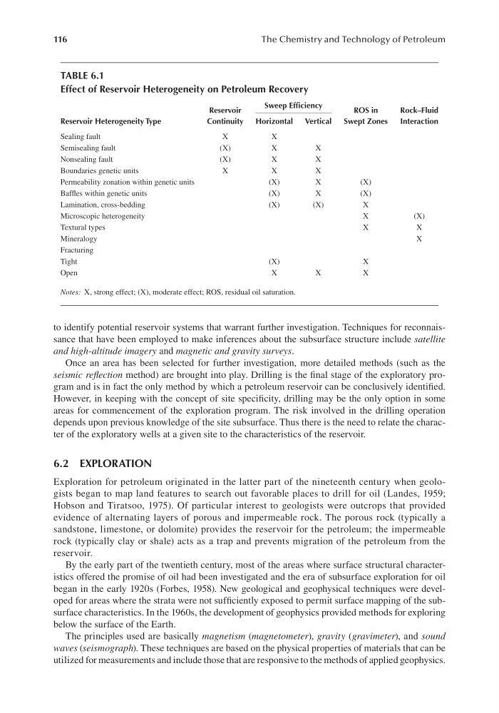
TABLE 6.1
Effect of Reservoir Heterogeneity on Petroleum Recovery
Reservoir Heterogeneity Type
Reservoir
Continuity
Sweep Efficiency
ROS in
Swept Zones
Rock–Fluid
Interaction
Horizontal
Vertical
Sealing fault
X
X
Semisealing fault
(X)
X
X
Nonsealing fault
(X)
X
X
Boundaries genetic units
X
X
X
Permeability zonation within genetic units
(X)
X
(X)
Baffles within genetic units
(X)
X
(X)
Lamination, cross-bedding
(X)
(X)
X
Microscopic heterogeneity
X
(X)
Textural types
X
X
Mineralogy
X
Fracturing
Tight
(X)
X
Open
X
X
X
Notes: X, strong effect; (X), moderate effect; ROS, residual oil saturation.
The Chemistry and Technology of Petroleum
to identify potential reservoir systems that warrant further investigation. Techniques for reconnaissance that have been employed to make inferences about the subsurface structure include satellite
and high-altitude imagery and magnetic and gravity surveys.
Once an area has been selected for further investigation, more detailed methods (such as the
seismic reflection method) are brought into play. Drilling is the final stage of the exploratory program and is in fact the only method by which a petroleum reservoir can be conclusively identified.
However, in keeping with the concept of site specificity, drilling may be the only option in some
areas for commencement of the exploration program. The risk involved in the drilling operation
depends upon previous knowledge of the site subsurface. Thus there is the need to relate the character of the exploratory wells at a given site to the characteristics of the reservoir.
6.2 EXPLORATION
Exploration for petroleum originated in the latter part of the nineteenth century when geologists began to map land features to search out favorable places to drill for oil (Landes, 1959;
Hobson and Tiratsoo, 1975). Of particular interest to geologists were outcrops that provided
evidence of alternating layers of porous and impermeable rock. The porous rock (typically a
sandstone, limestone, or dolomite) provides the reservoir for the petroleum; the impermeable
rock (typically clay or shale) acts as a trap and prevents migration of the petroleum from the
reservoir.
By the early part of the twentieth century, most of the areas where surface structural characteristics offered the promise of oil had been investigated and the era of subsurface exploration for oil
began in the early 1920s (Forbes, 1958). New geological and geophysical techniques were developed for areas where the strata were not sufficiently exposed to permit surface mapping of the subsurface characteristics. In the 1960s, the development of geophysics provided methods for exploring
below the surface of the Earth.
The principles used are basically magnetism (magnetometer), gravity (gravimeter), and sound
waves (seismograph). These techniques are based on the physical properties of materials that can be
utilized for measurements and include those that are responsive to the methods of applied geophysics.
TABLE 6.1
Effect of Reservoir Heterogeneity on Petroleum Recovery
Reservoir Heterogeneity Type
Reservoir
Continuity
Sweep Efficiency
ROS in
Swept Zones
Rock–Fluid
Interaction
Horizontal
Vertical
Sealing fault
X
X
Semisealing fault
(X)
X
X
Nonsealing fault
(X)
X
X
Boundaries genetic units
X
X
X
Permeability zonation within genetic units
(X)
X
(X)
Baffles within genetic units
(X)
X
(X)
Lamination, cross-bedding
(X)
(X)
X
Microscopic heterogeneity
X
(X)
Textural types
X
X
Mineralogy
X
Fracturing
Tight
(X)
X
Open
X
X
X
Notes: X, strong effect; (X), moderate effect; ROS, residual oil saturation.