

Sheet Reservoirs (SH Type}
509
HH8-65
2.22 km
HH3-65
HH21-65
3km
HH12-65
East
-2500
m
-2560
-2620
-2680
-2680
-2740
-2740
-2800
-2800
datum :::: : sea level
-2860
m
�B_j_ ___ .
_t } __ ___j f
km
-2920
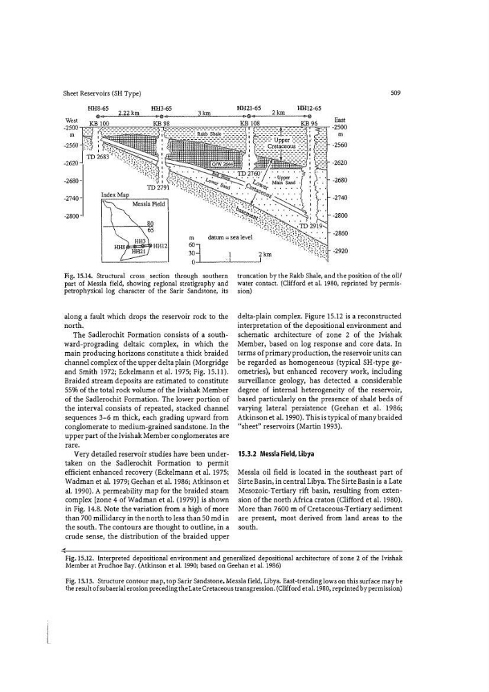
Fig. 15.14. Structural cross . section through southern
part of Messla field, showing regional stratigraphy and
petrophysical log character of the Sarir Sandstone, its
along a fault which drops the reservoir rock to the
north.
The Sadlerochit Formation consists of a southward-prograding deltaic complex, in which the
main producing horizons constitute a thick braided
channel complex of the upper delta plain (Morgridge
and Smith 1972; Eckelmann et al. 1975; Fig. 15.11).
Braided stream deposits are estimated to constitute
55% of the total rock volume of the Ivishak Member
of the Sadlerochit Formation. The lower portion of
the interval consists of repeated, stacked channel
sequences 3-6 m thick, each grading upward from
conglomerate to medium-grained sandstone. In the
upper part of the Ivishak Member conglomerates are
rare.
Very detailed reservoir studies have been undertaken on the Sadlerochit Formation to permit
efficient enhanced recovery (Eckelmann et al. 1975;
Wadman et al. 1979; Geehan et al. 1986; Atkinson et
al. 1990). A permeability map for the braided steam
complex [zone 4 of Wadman et al. (1979)] is shown
in Fig. 14.8. Note the variation from a high of more
than 700 millidarcy in the north to less than 50 md in
the south. The contours are thought to outline, in a
crude sense, the distribution of the braided upper
truncation by the Rakb Shale, and the position of the oil/
water contact. (Clifford et al. 1980, reprinted by permission)
delta-plain complex. Figure 15.12 is a reconstructed
interpretation of the depositional environment and
schematic architecture of zone 2 of the Ivishak
Member, based on log response and core data. In
terms of primary production, the reservoir units can
be regarded as homogeneous (typical SH-type geometries), but enhanced recovery work, including
surveillance geology, has detected a considerable
degree of internal heterogeneity of the reservoir,
based particularly on the presence of shale beds of
varying lateral persistence (Geehan et al. 1986;
Atkinson et al. 1990). This is typical of many braided
''sheet, reservoirs (Martin 1993).
15.3.2 Messla Field, Libya
Messla oil field is located in the southeast part of
Sirte Basin, in central Libya. The Sirte Basin is a Late
Mesozoic-Tertiary rift basin, resulting from extension of the north Africa craton (Clifford et al. 1980).
More than 7600 m of Cretaceous-Tertiary sediment
are present, most derived from land areas to the
south.
Fig. 15.12. Interpreted depositional environment and generalized depositional architecture of zone 2 of the Ivishak
Member at Prudhoe Bay. (Atkinson et al. 1990i based on Geehan et al. 1986)
Fig. 15.13. Structure J:;ontour map, top Sarir Sandstone, Messla field, Libya. EasHrending lows on this surface may be
the result of subaerial erosion preceding the Late Cretaceous transgression. (Clifford et al. 1980, reprinted by permission)