

Evaluation Models
19
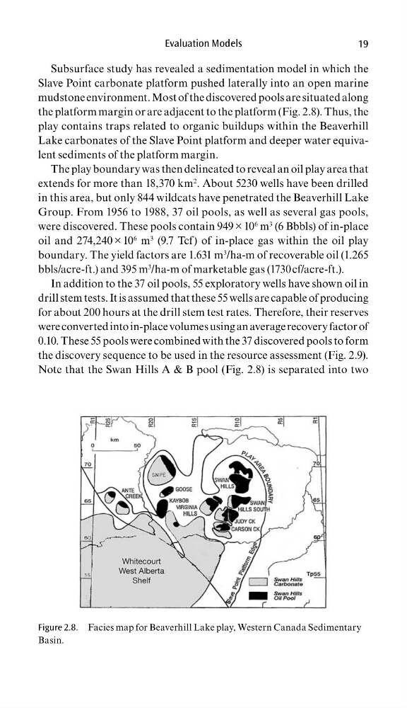
Subsurface study has revealed a sedimentation model in which the
Slave Point carbonate platform pushed laterally into an open marine
mudstone environment. Most of the discovered pools are situated along
the platform margin or are adjacent to the platform (Fig. 2.8). Thus, the
play contains traps related to organic buildups within the Beaverhill
Lake carbonates of the Slave Point platform and deeper water equivalent sediments of the platform margin.
The play boundary was then delineated to reveal an oil play area that
extends for more than 18,370 km
2 . About 5230 wells have been drilled
in this area, but only 844 wildcats have penetrated the Beaverhill Lake
Group. From 1956 to 1988, 37 oil pools, as well as several gas pools,
were discovered. These pools contain 949 × 10
6 m
3 (6 Bbbls) of in-place
oil and 274,240 × 10
6 m
3 (9.7 Tcf) of in-place gas within the oil play
boundary. The yield factors are 1.631 m
3 /ha-m of recoverable oil (1.265
bbls/acre-ft.) and 395 m
3 /ha-m of marketable gas (1730 cf/acre-ft.).
In addition to the 37 oil pools, 55 exploratory wells have shown oil in
drill stem tests. It is assumed that these 55 wells are capable of producing
for about 200 hours at the drill stem test rates. Therefore, their reserves
were converted into in-place volumes using an average recovery factor of
0.10. These 55 pools were combined with the 37 discovered pools to form
the discovery sequence to be used in the resource assessment (Fig. 2.9).
Note that the Swan Hills A & B pool (Fig. 2.8) is separated into two
Figure 2.8. Facies map for Beaverhill Lake play, Western Canada Sedimentary
Basin.
19
Subsurface study has revealed a sedimentation model in which the
Slave Point carbonate platform pushed laterally into an open marine
mudstone environment. Most of the discovered pools are situated along
the platform margin or are adjacent to the platform (Fig. 2.8). Thus, the
play contains traps related to organic buildups within the Beaverhill
Lake carbonates of the Slave Point platform and deeper water equivalent sediments of the platform margin.
The play boundary was then delineated to reveal an oil play area that
extends for more than 18,370 km
2 . About 5230 wells have been drilled
in this area, but only 844 wildcats have penetrated the Beaverhill Lake
Group. From 1956 to 1988, 37 oil pools, as well as several gas pools,
were discovered. These pools contain 949 × 10
6 m
3 (6 Bbbls) of in-place
oil and 274,240 × 10
6 m
3 (9.7 Tcf) of in-place gas within the oil play
boundary. The yield factors are 1.631 m
3 /ha-m of recoverable oil (1.265
bbls/acre-ft.) and 395 m
3 /ha-m of marketable gas (1730 cf/acre-ft.).
In addition to the 37 oil pools, 55 exploratory wells have shown oil in
drill stem tests. It is assumed that these 55 wells are capable of producing
for about 200 hours at the drill stem test rates. Therefore, their reserves
were converted into in-place volumes using an average recovery factor of
0.10. These 55 pools were combined with the 37 discovered pools to form
the discovery sequence to be used in the resource assessment (Fig. 2.9).
Note that the Swan Hills A & B pool (Fig. 2.8) is separated into two
Figure 2.8. Facies map for Beaverhill Lake play, Western Canada Sedimentary
Basin.