

x
Caspian region since it is one of the major access routes to Central Asia, and is part
of a broader region which is prone to instability and events which have a knock-on
effect on US and world interests.
An inland water basin with an area of 424,300 km
2
, the Caspian Sea is the largest
of all the water basins in the world. The sea is a salt-water mass with no natural connections to the world’s oceans, except by a system of rivers and canals. The average
depth of the Caspian is 184 m below sea-level, although at its deepest it plunges to
1098 m. It is connected to the Black Sea as well as the Baltic Sea by the channels
added to the arms of the Volga and Don rivers. The northern and southern coastlines
are separated by approximately 1200 km of water, while its width from east to west
ranges from 210 to 490 km. Its coastline covers a total length of 7010 km, with
1193 km of this controlled by the Russian Federation, with 1200 km in Turkmenistan,
800 km in Azerbaijan, and 740 km along the Iranian coast (www.eia.gov 2015). The
Caspian Basin, Volga, Kura, Terek, Ural, Emba, Atrek, and Gurgan are the largest of
130 rivers which feed into this great water body. The economic, strategic, social,
and ecological importance of the Caspian draws from its location at the crossing
point of various global regions as well as its rich reserves of oil and gas, which have
been recognized as being far greater than previously thought during the Cold War.
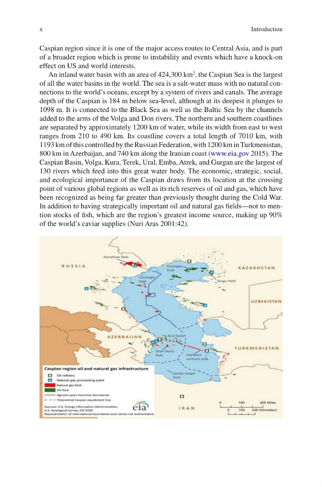
In addition to having strategically important oil and natural gas fields—not to mention stocks of fish, which are the region’s greatest income source, making up 90%
of the world’s caviar supplies (Nuri Aras 2001:42).
Introduction
Caspian region since it is one of the major access routes to Central Asia, and is part
of a broader region which is prone to instability and events which have a knock-on
effect on US and world interests.
An inland water basin with an area of 424,300 km
2
, the Caspian Sea is the largest
of all the water basins in the world. The sea is a salt-water mass with no natural connections to the world’s oceans, except by a system of rivers and canals. The average
depth of the Caspian is 184 m below sea-level, although at its deepest it plunges to
1098 m. It is connected to the Black Sea as well as the Baltic Sea by the channels
added to the arms of the Volga and Don rivers. The northern and southern coastlines
are separated by approximately 1200 km of water, while its width from east to west
ranges from 210 to 490 km. Its coastline covers a total length of 7010 km, with
1193 km of this controlled by the Russian Federation, with 1200 km in Turkmenistan,
800 km in Azerbaijan, and 740 km along the Iranian coast (www.eia.gov 2015). The
Caspian Basin, Volga, Kura, Terek, Ural, Emba, Atrek, and Gurgan are the largest of
130 rivers which feed into this great water body. The economic, strategic, social,
and ecological importance of the Caspian draws from its location at the crossing
point of various global regions as well as its rich reserves of oil and gas, which have
been recognized as being far greater than previously thought during the Cold War.
In addition to having strategically important oil and natural gas fields—not to mention stocks of fish, which are the region’s greatest income source, making up 90%
of the world’s caviar supplies (Nuri Aras 2001:42).
Introduction