

164
W. Cai et al.
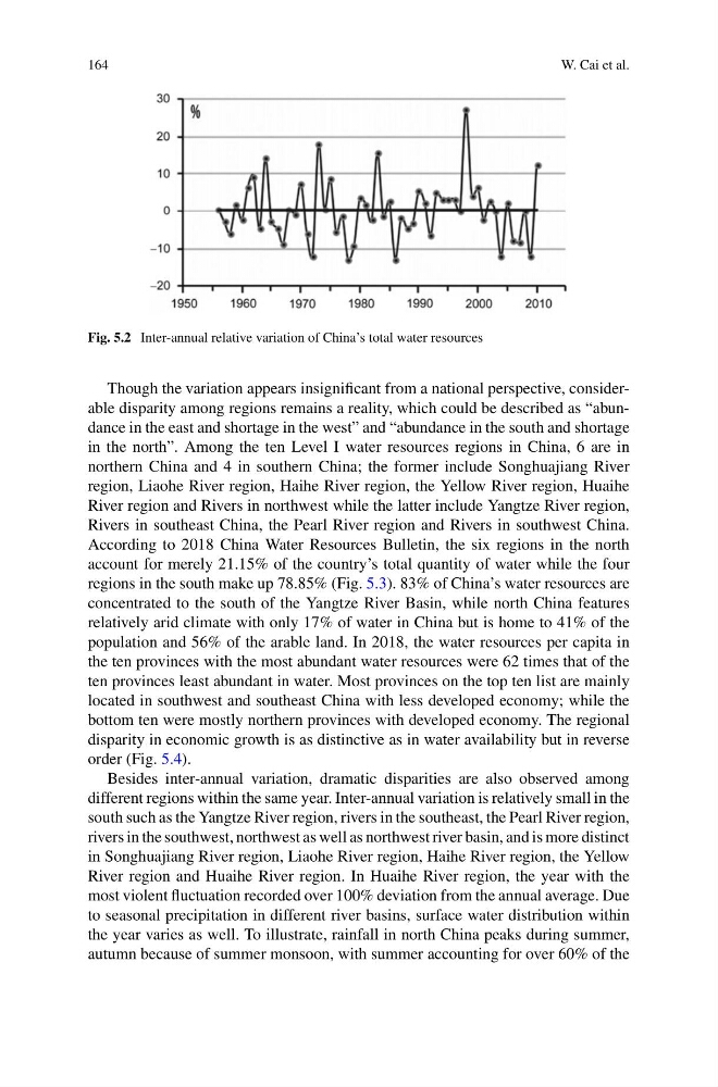
Fig. 5.2 Inter-annual relative variation of China’s total water resources
Though the variation appears insignificant from a national perspective, considerable disparity among regions remains a reality, which could be described as “abundance in the east and shortage in the west” and “abundance in the south and shortage
in the north”. Among the ten Level I water resources regions in China, 6 are in
northern China and 4 in southern China; the former include Songhuajiang River
region, Liaohe River region, Haihe River region, the Yellow River region, Huaihe
River region and Rivers in northwest while the latter include Yangtze River region,
Rivers in southeast China, the Pearl River region and Rivers in southwest China.
According to 2018 China Water Resources Bulletin, the six regions in the north
account for merely 21.15% of the country’s total quantity of water while the four
regions in the south make up 78.85% (Fig. 5.3). 83% of China’s water resources are
concentrated to the south of the Yangtze River Basin, while north China features
relatively arid climate with only 17% of water in China but is home to 41% of the
population and 56% of the arable land. In 2018, the water resources per capita in
the ten provinces with the most abundant water resources were 62 times that of the
ten provinces least abundant in water. Most provinces on the top ten list are mainly
located in southwest and southeast China with less developed economy; while the
bottom ten were mostly northern provinces with developed economy. The regional
disparity in economic growth is as distinctive as in water availability but in reverse
order (Fig. 5.4).
Besides inter-annual variation, dramatic disparities are also observed among
different regions within the same year. Inter-annual variation is relatively small in the
south such as the Yangtze River region, rivers in the southeast, the Pearl River region,
rivers in the southwest, northwest as well as northwest river basin, and is more distinct
in Songhuajiang River region, Liaohe River region, Haihe River region, the Yellow
River region and Huaihe River region. In Huaihe River region, the year with the
most violent fluctuation recorded over 100% deviation from the annual average. Due
to seasonal precipitation in different river basins, surface water distribution within
the year varies as well. To illustrate, rainfall in north China peaks during summer,
autumn because of summer monsoon, with summer accounting for over 60% of the
W. Cai et al.
Fig. 5.2 Inter-annual relative variation of China’s total water resources
Though the variation appears insignificant from a national perspective, considerable disparity among regions remains a reality, which could be described as “abundance in the east and shortage in the west” and “abundance in the south and shortage
in the north”. Among the ten Level I water resources regions in China, 6 are in
northern China and 4 in southern China; the former include Songhuajiang River
region, Liaohe River region, Haihe River region, the Yellow River region, Huaihe
River region and Rivers in northwest while the latter include Yangtze River region,
Rivers in southeast China, the Pearl River region and Rivers in southwest China.
According to 2018 China Water Resources Bulletin, the six regions in the north
account for merely 21.15% of the country’s total quantity of water while the four
regions in the south make up 78.85% (Fig. 5.3). 83% of China’s water resources are
concentrated to the south of the Yangtze River Basin, while north China features
relatively arid climate with only 17% of water in China but is home to 41% of the
population and 56% of the arable land. In 2018, the water resources per capita in
the ten provinces with the most abundant water resources were 62 times that of the
ten provinces least abundant in water. Most provinces on the top ten list are mainly
located in southwest and southeast China with less developed economy; while the
bottom ten were mostly northern provinces with developed economy. The regional
disparity in economic growth is as distinctive as in water availability but in reverse
order (Fig. 5.4).
Besides inter-annual variation, dramatic disparities are also observed among
different regions within the same year. Inter-annual variation is relatively small in the
south such as the Yangtze River region, rivers in the southeast, the Pearl River region,
rivers in the southwest, northwest as well as northwest river basin, and is more distinct
in Songhuajiang River region, Liaohe River region, Haihe River region, the Yellow
River region and Huaihe River region. In Huaihe River region, the year with the
most violent fluctuation recorded over 100% deviation from the annual average. Due
to seasonal precipitation in different river basins, surface water distribution within
the year varies as well. To illustrate, rainfall in north China peaks during summer,
autumn because of summer monsoon, with summer accounting for over 60% of the