

58
R. Chettri et al.
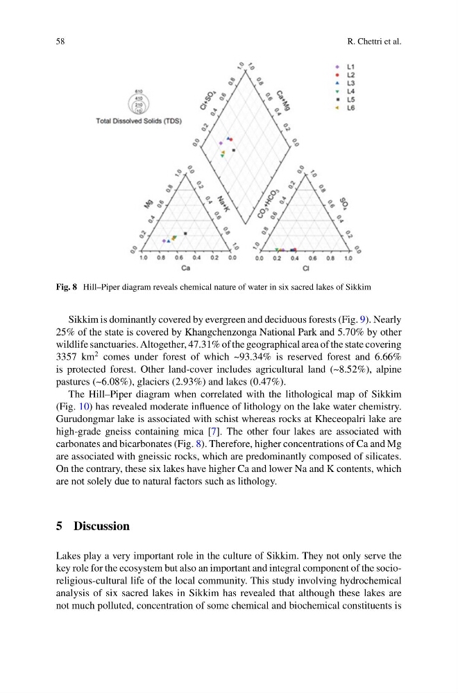
Fig. 8 Hill–Piper diagram reveals chemical nature of water in six sacred lakes of Sikkim
Sikkim is dominantly covered by evergreen and deciduous forests (Fig. 9). Nearly
25% of the state is covered by Khangchenzonga National Park and 5.70% by other
wildlife sanctuaries. Altogether, 47.31% of the geographical area of the state covering
3357 km
2 comes under forest of which ~93.34% is reserved forest and 6.66%
is protected forest. Other land-cover includes agricultural land (~8.52%), alpine
pastures (~6.08%), glaciers (2.93%) and lakes (0.47%).
The Hill–Piper diagram when correlated with the lithological map of Sikkim
(Fig. 10) has revealed moderate influence of lithology on the lake water chemistry.
Gurudongmar lake is associated with schist whereas rocks at Kheceopalri lake are
high-grade gneiss containing mica [7]. The other four lakes are associated with
carbonates and bicarbonates (Fig. 8). Therefore, higher concentrations of Ca and Mg
are associated with gneissic rocks, which are predominantly composed of silicates.
On the contrary, these six lakes have higher Ca and lower Na and K contents, which
are not solely due to natural factors such as lithology.
5 Discussion
Lakes play a very important role in the culture of Sikkim. They not only serve the
key role for the ecosystem but also an important and integral component of the socioreligious-cultural life of the local community. This study involving hydrochemical
analysis of six sacred lakes in Sikkim has revealed that although these lakes are
not much polluted, concentration of some chemical and biochemical constituents is
R. Chettri et al.
Fig. 8 Hill–Piper diagram reveals chemical nature of water in six sacred lakes of Sikkim
Sikkim is dominantly covered by evergreen and deciduous forests (Fig. 9). Nearly
25% of the state is covered by Khangchenzonga National Park and 5.70% by other
wildlife sanctuaries. Altogether, 47.31% of the geographical area of the state covering
3357 km
2 comes under forest of which ~93.34% is reserved forest and 6.66%
is protected forest. Other land-cover includes agricultural land (~8.52%), alpine
pastures (~6.08%), glaciers (2.93%) and lakes (0.47%).
The Hill–Piper diagram when correlated with the lithological map of Sikkim
(Fig. 10) has revealed moderate influence of lithology on the lake water chemistry.
Gurudongmar lake is associated with schist whereas rocks at Kheceopalri lake are
high-grade gneiss containing mica [7]. The other four lakes are associated with
carbonates and bicarbonates (Fig. 8). Therefore, higher concentrations of Ca and Mg
are associated with gneissic rocks, which are predominantly composed of silicates.
On the contrary, these six lakes have higher Ca and lower Na and K contents, which
are not solely due to natural factors such as lithology.
5 Discussion
Lakes play a very important role in the culture of Sikkim. They not only serve the
key role for the ecosystem but also an important and integral component of the socioreligious-cultural life of the local community. This study involving hydrochemical
analysis of six sacred lakes in Sikkim has revealed that although these lakes are
not much polluted, concentration of some chemical and biochemical constituents is