

It is therefore important to check the time at which the
geodynamo was set up. To do this, it is necessary to find very
old rocks that would have registered and retained a primary
magnetization. Samples taken from the Matachewan Dikes
dated at 2.5 Ga or basalts from the Fortescue Basin of the
Pilbara Craton (Australia) dated at 2.7 Ga yielded a primary
remanent magnetization which suggests the presence of a
dipolar magnetic field at the end of the Archean (Tarduno et al.
2014). Knowing this, it is technically possible to measure the
direction of magnetization from this time onwards. But what
about rocks older than this? Archean formations are highly
likely to have undergone a complex geological history, and, in
particular, one or more episodes of metamorphism erasing the
primary magnetic signal in favor of a more recent secondary
magnetization. To overcome this problem, a technique based
on the measurement of the magnetization carried by an isolated
mineral (single feldspar, quartz phenocrysts) was developed to
show the presence of a magnetic field as far back as 3.5 Ga.
Finally, zircons dated between 3.3 and 4.2 Ga discovered in
the Jack Hills metaconglomerate showed a magnetic signal
carried by magnetite and considered to be primary. The paleointensity of the magnetic field (not its direction) was measured and it varies between 12 and 100% of the value of the
current field at the equator possibly suggesting the presence of
a terrestrial magnetic field as far back as the Hadean era
(Tarduno et al. 2015).
The geomagnetic field H at any point on the surface of
the globe can be defined by two angles, the declination D
(angle between the magnetic north and the geographic north
(counted positive east of true north)) and the inclination I
(the angle between the horizontal plane and the direction of
the fieldH (counted positive if downward)). At the first
order, the present-day magnetic field can be represented by
the field produced by a magnetic dipole inclined to the
Earth’s axis of rotation by 11.5° and slightly off-centered by
about 500 km from the center of the Earth. Differences
between the current magnetic field and this theoretical field
exist locally, as evidenced by the contribution of non-dipolar
terms (quadrupole, octupole). In the even stronger hypothesis of a perfectly dipolar, axial and centered magnetic field,
a simple mathematical relation connects the magnetic inclination measured at a point of the Earth’s surface to the
latitude of this point. In other words, knowing the inclination
of the magnetization vector fossilized by the magnetic
minerals at a site at different times in the past allows us to
calculate the successive paleolatitudes of this site by
assuming that the geomagnetic pole has always coincided
with the geographical pole, itself supposed fixed. Conversely, from a set of samples distributed over a continental
land mass, we can calculate the position of the magnetic pole
associated with the continent or geological mass under
consideration, always assuming the axial and centered dipole
magnetic field: this is therefore a “virtual” geomagnetic pole
(VGP), since the reference is a continental land mass whose
past position is not known.
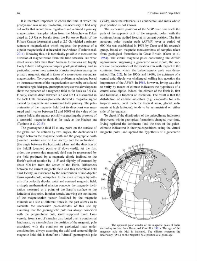
The successive positions of the VGP over time track the
path of the apparent drift of the magnetic poles, with the
continent being studied fixed at its current position. The first
apparent polar wander path (APWP) over a period of
600 Ma was established in 1954 by Creer and his research
group, based on magnetic measurements of samples taken
from geological formations in Great Britain (Creer et al.
1954). The virtual magnetic poles constituting the APWP
approximate, supposing a geocentric axial dipole, the successive paleopositions of the rotation axis with respect to the
continent from which the paleomagnetic pole was determined (Fig. 2.2). In the 1950s and 1960s, the existence of a
central axial dipole was challenged, calling into question the
importance of the APWP. In 1964, however, Irving was able
to verify by means of climate indicators the hypothesis of a
central axial dipole. Indeed, the climate of the Earth is, first
and foremost, a function of insolation. The result is that the
distribution of climate indicators (e.g. evaporites for subtropical zones, coral reefs for tropical areas, glacial sediments at high latitudes), tends to be symmetrical on either
side of the equator.
To check if the distribution of the paleoclimate indicators
discovered within geological formations changed over time,
Irving replaced the continents (and the sites of the paleoclimatic indicators) in their paleopositions, using the virtual
magnetic poles, and applied the hypothesis of a geocentric
Fig. 2.2 The apparent polar wander of the magnetic poles of India
(according to data from Besse and Courtillot 1991). The age of the
magnetic pole (in Ma) is indicated. The ellipses represent the
uncertainty (95%) on the magnetic pole position at a given age
26
F. Fluteau and P. Sepulchre
geodynamo was set up. To do this, it is necessary to find very
old rocks that would have registered and retained a primary
magnetization. Samples taken from the Matachewan Dikes
dated at 2.5 Ga or basalts from the Fortescue Basin of the
Pilbara Craton (Australia) dated at 2.7 Ga yielded a primary
remanent magnetization which suggests the presence of a
dipolar magnetic field at the end of the Archean (Tarduno et al.
2014). Knowing this, it is technically possible to measure the
direction of magnetization from this time onwards. But what
about rocks older than this? Archean formations are highly
likely to have undergone a complex geological history, and, in
particular, one or more episodes of metamorphism erasing the
primary magnetic signal in favor of a more recent secondary
magnetization. To overcome this problem, a technique based
on the measurement of the magnetization carried by an isolated
mineral (single feldspar, quartz phenocrysts) was developed to
show the presence of a magnetic field as far back as 3.5 Ga.
Finally, zircons dated between 3.3 and 4.2 Ga discovered in
the Jack Hills metaconglomerate showed a magnetic signal
carried by magnetite and considered to be primary. The paleointensity of the magnetic field (not its direction) was measured and it varies between 12 and 100% of the value of the
current field at the equator possibly suggesting the presence of
a terrestrial magnetic field as far back as the Hadean era
(Tarduno et al. 2015).
The geomagnetic field H at any point on the surface of
the globe can be defined by two angles, the declination D
(angle between the magnetic north and the geographic north
(counted positive east of true north)) and the inclination I
(the angle between the horizontal plane and the direction of
the fieldH (counted positive if downward)). At the first
order, the present-day magnetic field can be represented by
the field produced by a magnetic dipole inclined to the
Earth’s axis of rotation by 11.5° and slightly off-centered by
about 500 km from the center of the Earth. Differences
between the current magnetic field and this theoretical field
exist locally, as evidenced by the contribution of non-dipolar
terms (quadrupole, octupole). In the even stronger hypothesis of a perfectly dipolar, axial and centered magnetic field,
a simple mathematical relation connects the magnetic inclination measured at a point of the Earth’s surface to the
latitude of this point. In other words, knowing the inclination
of the magnetization vector fossilized by the magnetic
minerals at a site at different times in the past allows us to
calculate the successive paleolatitudes of this site by
assuming that the geomagnetic pole has always coincided
with the geographical pole, itself supposed fixed. Conversely, from a set of samples distributed over a continental
land mass, we can calculate the position of the magnetic pole
associated with the continent or geological mass under
consideration, always assuming the axial and centered dipole
magnetic field: this is therefore a “virtual” geomagnetic pole
(VGP), since the reference is a continental land mass whose
past position is not known.
The successive positions of the VGP over time track the
path of the apparent drift of the magnetic poles, with the
continent being studied fixed at its current position. The first
apparent polar wander path (APWP) over a period of
600 Ma was established in 1954 by Creer and his research
group, based on magnetic measurements of samples taken
from geological formations in Great Britain (Creer et al.
1954). The virtual magnetic poles constituting the APWP
approximate, supposing a geocentric axial dipole, the successive paleopositions of the rotation axis with respect to the
continent from which the paleomagnetic pole was determined (Fig. 2.2). In the 1950s and 1960s, the existence of a
central axial dipole was challenged, calling into question the
importance of the APWP. In 1964, however, Irving was able
to verify by means of climate indicators the hypothesis of a
central axial dipole. Indeed, the climate of the Earth is, first
and foremost, a function of insolation. The result is that the
distribution of climate indicators (e.g. evaporites for subtropical zones, coral reefs for tropical areas, glacial sediments at high latitudes), tends to be symmetrical on either
side of the equator.
To check if the distribution of the paleoclimate indicators
discovered within geological formations changed over time,
Irving replaced the continents (and the sites of the paleoclimatic indicators) in their paleopositions, using the virtual
magnetic poles, and applied the hypothesis of a geocentric
Fig. 2.2 The apparent polar wander of the magnetic poles of India
(according to data from Besse and Courtillot 1991). The age of the
magnetic pole (in Ma) is indicated. The ellipses represent the
uncertainty (95%) on the magnetic pole position at a given age
26
F. Fluteau and P. Sepulchre