

and evaporation at the surface of the lake (m), A (m
3
) is the
sum of the surface and subterranean inflows. A is dependent
on the P-E balance of the watershed (P B − E B ) and its
surface S B . D (m
3 ) is the sum of the losses from the surface
and from infiltration at the bottom of the lake. Equation (19.1) shows that closed lakes (D = 0), common in
semi-arid or arid areas, are the most sensitive because they
cumulate variations in the P-E of the lake and of its watershed. Thus, they amplify the responses to climate change.
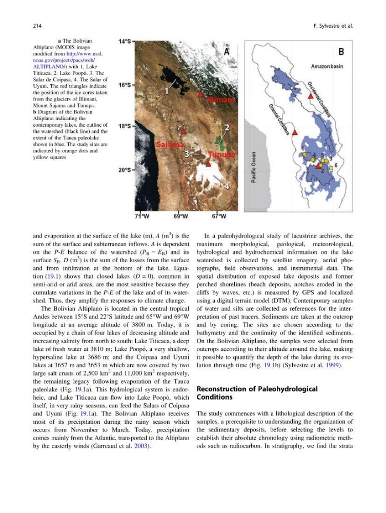
The Bolivian Altiplano is located in the central tropical
Andes between 15°S and 22°S latitude and 65°W and 69°W
longitude at an average altitude of 3800 m. Today, it is
occupied by a chain of four lakes of decreasing altitude and
increasing salinity from north to south: Lake Titicaca, a deep
lake of fresh water at 3810 m; Lake Poopó, a very shallow,
hypersaline lake at 3686 m; and the Coipasa and Uyuni
lakes at 3657 m and 3653 m which are now covered by two
large salt crusts of 2,500 km
2 and 11,000 km
2 respectively,
the remaining legacy following evaporation of the Tauca
paleolake (Fig. 19.1a). This hydrological system is endorheic, and Lake Titicaca can flow into Lake Poopó, which
itself, in very rainy seasons, can feed the Salars of Coipasa
and Uyuni (Fig. 19.1a). The Bolivian Altiplano receives
most of its precipitation during the rainy season which
occurs from November to March. Today, precipitation
comes mainly from the Atlantic, transported to the Altiplano
by the easterly winds (Garreaud et al. 2003).
In a paleohydrological study of lacustrine archives, the
maximum morphological, geological, meteorological,
hydrological and hydrochemical information on the lake
watershed is collected by satellite imagery, aerial photographs, field observations, and instrumental data. The
spatial distribution of exposed lake deposits and former
perched shorelines (beach deposits, notches eroded in the
cliffs by waves, etc.) is measured by GPS and localized
using a digital terrain model (DTM). Contemporary samples
of water and silts are collected as references for the interpretation of past tracers. Sediments are taken at the outcrop
and by coring. The sites are chosen according to the
bathymetry and the continuity of the identified sediments.
On the Bolivian Altiplano, the samples were selected from
outcrops according to their altitude around the lake, making
it possible to quantify the depth of the lake during its evolution through time (Fig. 19.1b) (Sylvestre et al. 1999).
Reconstruction of Paleohydrological
Conditions
The study commences with a lithological description of the
samples, a prerequisite to understanding the organization of
the sedimentary deposits, before selecting the levels to
establish their absolute chronology using radiometric methods such as radiocarbon. In stratigraphy, we find the strata
Fig. 19.1 a The Bolivian
Altiplano (MODIS image
modified from http://www.nssl.
noaa.gov/projects/pacs/web/
ALTIPLANO/) with 1. Lake
Titicaca, 2. Lake Poopó, 3. The
Salar de Coipasa, 4. The Salar of
Uyuni. The red triangles indicate
the position of the ice cores taken
from the glaciers of Illimani,
Mount Sajama and Tunupa.
b Diagram of the Bolivian
Altiplano indicating the
contemporary lakes, the outline of
the watershed (black line) and the
extent of the Tauca paleolake
shown in blue. The study sites are
indicated by orange dots and
yellow squares
214
F. Sylvestre et al.
3
) is the
sum of the surface and subterranean inflows. A is dependent
on the P-E balance of the watershed (P B − E B ) and its
surface S B . D (m
3 ) is the sum of the losses from the surface
and from infiltration at the bottom of the lake. Equation (19.1) shows that closed lakes (D = 0), common in
semi-arid or arid areas, are the most sensitive because they
cumulate variations in the P-E of the lake and of its watershed. Thus, they amplify the responses to climate change.
The Bolivian Altiplano is located in the central tropical
Andes between 15°S and 22°S latitude and 65°W and 69°W
longitude at an average altitude of 3800 m. Today, it is
occupied by a chain of four lakes of decreasing altitude and
increasing salinity from north to south: Lake Titicaca, a deep
lake of fresh water at 3810 m; Lake Poopó, a very shallow,
hypersaline lake at 3686 m; and the Coipasa and Uyuni
lakes at 3657 m and 3653 m which are now covered by two
large salt crusts of 2,500 km
2 and 11,000 km
2 respectively,
the remaining legacy following evaporation of the Tauca
paleolake (Fig. 19.1a). This hydrological system is endorheic, and Lake Titicaca can flow into Lake Poopó, which
itself, in very rainy seasons, can feed the Salars of Coipasa
and Uyuni (Fig. 19.1a). The Bolivian Altiplano receives
most of its precipitation during the rainy season which
occurs from November to March. Today, precipitation
comes mainly from the Atlantic, transported to the Altiplano
by the easterly winds (Garreaud et al. 2003).
In a paleohydrological study of lacustrine archives, the
maximum morphological, geological, meteorological,
hydrological and hydrochemical information on the lake
watershed is collected by satellite imagery, aerial photographs, field observations, and instrumental data. The
spatial distribution of exposed lake deposits and former
perched shorelines (beach deposits, notches eroded in the
cliffs by waves, etc.) is measured by GPS and localized
using a digital terrain model (DTM). Contemporary samples
of water and silts are collected as references for the interpretation of past tracers. Sediments are taken at the outcrop
and by coring. The sites are chosen according to the
bathymetry and the continuity of the identified sediments.
On the Bolivian Altiplano, the samples were selected from
outcrops according to their altitude around the lake, making
it possible to quantify the depth of the lake during its evolution through time (Fig. 19.1b) (Sylvestre et al. 1999).
Reconstruction of Paleohydrological
Conditions
The study commences with a lithological description of the
samples, a prerequisite to understanding the organization of
the sedimentary deposits, before selecting the levels to
establish their absolute chronology using radiometric methods such as radiocarbon. In stratigraphy, we find the strata
Fig. 19.1 a The Bolivian
Altiplano (MODIS image
modified from http://www.nssl.
noaa.gov/projects/pacs/web/
ALTIPLANO/) with 1. Lake
Titicaca, 2. Lake Poopó, 3. The
Salar de Coipasa, 4. The Salar of
Uyuni. The red triangles indicate
the position of the ice cores taken
from the glaciers of Illimani,
Mount Sajama and Tunupa.
b Diagram of the Bolivian
Altiplano indicating the
contemporary lakes, the outline of
the watershed (black line) and the
extent of the Tauca paleolake
shown in blue. The study sites are
indicated by orange dots and
yellow squares
214
F. Sylvestre et al.