

Sahara, Kalahari and Arid Zones:
Discontinuous Evidence of Hydrological
Inversions
Since the 1950s and 1960s, the first robust evidence of major
hydrological changes during the late Pleistocene and Holocene, have been found in the two African subtropical deserts
in the form of proof of the existence of gigantic interdune
lakes; flora and fauna assemblages; sites demonstrating a
sedentary human presence and a positive water balance over
centuries or millennia. A key outcome of this research is
indications that, during the first half of the Holocene, there
was an intensification of the African monsoon in the Sahara
and a shift in the tropical summer rains (at the northern limit
of the ITCZ) north of 20°N as well as a significant reduction
in the Sahara as a biogeographical barrier during this period
(Lézine et al. 1990; Petit-Maire and Riser 1981). Very
similar evidence of major hydrological changes has been
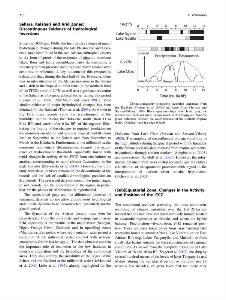
obtained for the Kalahari (Thomas et al. 2003). As shown in
Fig. 18.1, these records show the asynchronism of the
humidity ‘optima’ during the Holocene, north (from 11 to
6 ka BP) and south (after 6 ka BP) of the equator, illustrating the forcing of the changes in regional insolation on
the monsoon circulation and summer tropical rainfall (from
June to September in the Sahara and from December to
March in the Kalahari). Furthermore, at the millennial scale,
numerous sedimentary discontinuities suggest the occurrence of hydroclimatic thresholds, apparently linked with
rapid changes in activity of the ITCZ from one latitude to
another, corresponding to rapid climate fluctuations in the
high latitudes (Mayewski et al. 2004). However, the difficulty with these archives remains in the discontinuity of the
records and the lack of detailed chronological precision on
dry periods. The preserved deposits contain the initial stages
of wet periods, but the preservation of the signal, in particular for the phases of aridification, is hypothetical.
The depositional gaps and the differential removal of
remaining deposits do not allow a continuous hydrological
and climate dynamic to be reconstructed, particularly for the
glacial period.
The dynamics of the African deserts must then be
reconstructed from the proximate and hemipelagic marine
field, especially at the mouths of the major rivers (Senegal,
Niger, Orange River, Zambezi) and in upwelling zones
(Mauritania, Benguela), where sedimentation rates permit a
resolution at the millennial scale, coupled with isotopic
stratigraphy for the last ice age(s). The data obtained confirm
the important role of insolation in the low latitudes in
monsoon circulation and the hydrology of the subtropical
areas. They also confirm the instability of the edges of the
Sahara and the Kalahari at the millennial scale (DeMenocal
et al. 2000; Little et al. 1997), already highlighted for the
Holocene from Lake Chad (Servant and Servant-Vildary
1980). The coupling of the millennial climate variability in
the high latitudes during the glacial period with the humidity
of the Sahara is clearly demonstrated from marine sediments,
in particular through erosion markers (Adegbie et al. 2003)
and ecosystems (Schefuß et al. 2005). However, the information obtained often lacks spatial accuracy, and the critical
contribution of transportation processes with regard to the
interpretation of markers often remains hypothetical
(Pichevin et al. 2005).
(Sub)Equatorial Zone: Changes in the Activity
and Position of the ITCZ
The continental archives providing the most continuous
recording of climate variability over the last 25 ka are
located in sites that have remained relatively humid, located
in equatorial regions or at altitude, and where the hydric
balance [Precipitation—Evaporation, P-E) remained positive. These are cores taken either from large terminal lake
reservoirs found in central Africa (Lake Victoria) or the East
African Rift (e.g. Lakes Tanganyika and Malawi), or from
small lake basins suitable for the reconstruction of regional
conditions. As shown from the complete drying up of Lake
Victoria at 18 and 16 ka BP (Stager et al. 2002), the drop by
several hundred meters of the levels of lakes Tanganyika and
Malawi during the last glacial period, or the rapid rise 18
(over a few decades) of great lakes that are today very
Fig. 18.1 Chronostratigraphy comparing lacustrine sequences from
the Kalahari (Thomas et al. 2003) and Lake Chad (Servant and
Servant-Vildary 1980). Black represents high water level; gray, the
intermediate level; and white the low water level or drying out. Note the
phase difference between the water balances of the southern tropical
region (Kalahari) and the edge (Chad)
210
D. Williamson
Discontinuous Evidence of Hydrological
Inversions
Since the 1950s and 1960s, the first robust evidence of major
hydrological changes during the late Pleistocene and Holocene, have been found in the two African subtropical deserts
in the form of proof of the existence of gigantic interdune
lakes; flora and fauna assemblages; sites demonstrating a
sedentary human presence and a positive water balance over
centuries or millennia. A key outcome of this research is
indications that, during the first half of the Holocene, there
was an intensification of the African monsoon in the Sahara
and a shift in the tropical summer rains (at the northern limit
of the ITCZ) north of 20°N as well as a significant reduction
in the Sahara as a biogeographical barrier during this period
(Lézine et al. 1990; Petit-Maire and Riser 1981). Very
similar evidence of major hydrological changes has been
obtained for the Kalahari (Thomas et al. 2003). As shown in
Fig. 18.1, these records show the asynchronism of the
humidity ‘optima’ during the Holocene, north (from 11 to
6 ka BP) and south (after 6 ka BP) of the equator, illustrating the forcing of the changes in regional insolation on
the monsoon circulation and summer tropical rainfall (from
June to September in the Sahara and from December to
March in the Kalahari). Furthermore, at the millennial scale,
numerous sedimentary discontinuities suggest the occurrence of hydroclimatic thresholds, apparently linked with
rapid changes in activity of the ITCZ from one latitude to
another, corresponding to rapid climate fluctuations in the
high latitudes (Mayewski et al. 2004). However, the difficulty with these archives remains in the discontinuity of the
records and the lack of detailed chronological precision on
dry periods. The preserved deposits contain the initial stages
of wet periods, but the preservation of the signal, in particular for the phases of aridification, is hypothetical.
The depositional gaps and the differential removal of
remaining deposits do not allow a continuous hydrological
and climate dynamic to be reconstructed, particularly for the
glacial period.
The dynamics of the African deserts must then be
reconstructed from the proximate and hemipelagic marine
field, especially at the mouths of the major rivers (Senegal,
Niger, Orange River, Zambezi) and in upwelling zones
(Mauritania, Benguela), where sedimentation rates permit a
resolution at the millennial scale, coupled with isotopic
stratigraphy for the last ice age(s). The data obtained confirm
the important role of insolation in the low latitudes in
monsoon circulation and the hydrology of the subtropical
areas. They also confirm the instability of the edges of the
Sahara and the Kalahari at the millennial scale (DeMenocal
et al. 2000; Little et al. 1997), already highlighted for the
Holocene from Lake Chad (Servant and Servant-Vildary
1980). The coupling of the millennial climate variability in
the high latitudes during the glacial period with the humidity
of the Sahara is clearly demonstrated from marine sediments,
in particular through erosion markers (Adegbie et al. 2003)
and ecosystems (Schefuß et al. 2005). However, the information obtained often lacks spatial accuracy, and the critical
contribution of transportation processes with regard to the
interpretation of markers often remains hypothetical
(Pichevin et al. 2005).
(Sub)Equatorial Zone: Changes in the Activity
and Position of the ITCZ
The continental archives providing the most continuous
recording of climate variability over the last 25 ka are
located in sites that have remained relatively humid, located
in equatorial regions or at altitude, and where the hydric
balance [Precipitation—Evaporation, P-E) remained positive. These are cores taken either from large terminal lake
reservoirs found in central Africa (Lake Victoria) or the East
African Rift (e.g. Lakes Tanganyika and Malawi), or from
small lake basins suitable for the reconstruction of regional
conditions. As shown from the complete drying up of Lake
Victoria at 18 and 16 ka BP (Stager et al. 2002), the drop by
several hundred meters of the levels of lakes Tanganyika and
Malawi during the last glacial period, or the rapid rise 18
(over a few decades) of great lakes that are today very
Fig. 18.1 Chronostratigraphy comparing lacustrine sequences from
the Kalahari (Thomas et al. 2003) and Lake Chad (Servant and
Servant-Vildary 1980). Black represents high water level; gray, the
intermediate level; and white the low water level or drying out. Note the
phase difference between the water balances of the southern tropical
region (Kalahari) and the edge (Chad)
210
D. Williamson