

15 In-flight Icing: Modeling, Prediction, and Uncertainty
459
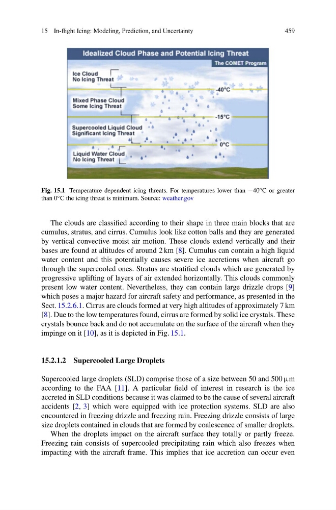
Fig. 15.1 Temperature dependent icing threats. For temperatures lower than −40 ◦ C or greater
than 0 ◦ C the icing threat is minimum. Source: weather.gov
The clouds are classified according to their shape in three main blocks that are
cumulus, stratus, and cirrus. Cumulus look like cotton balls and they are generated
by vertical convective moist air motion. These clouds extend vertically and their
bases are found at altitudes of around 2 km [8]. Cumulus can contain a high liquid
water content and this potentially causes severe ice accretions when aircraft go
through the supercooled ones. Stratus are stratified clouds which are generated by
progressive uplifting of layers of air extended horizontally. This clouds commonly
present low water content. Nevertheless, they can contain large drizzle drops [9]
which poses a major hazard for aircraft safety and performance, as presented in the
Sect. 15.2.6.1. Cirrus are clouds formed at very high altitudes of approximately 7 km
[8]. Due to the low temperatures found, cirrus are formed by solid ice crystals. These
crystals bounce back and do not accumulate on the surface of the aircraft when they
impinge on it [10], as it is depicted in Fig. 15.1.
15.2.1.2 Supercooled Large Droplets
Supercooled large droplets (SLD) comprise those of a size between 50 and 500 μm
according to the FAA [11]. A particular field of interest in research is the ice
accreted in SLD conditions because it was claimed to be the cause of several aircraft
accidents [2, 3] which were equipped with ice protection systems. SLD are also
encountered in freezing drizzle and freezing rain. Freezing drizzle consists of large
size droplets contained in clouds that are formed by coalescence of smaller droplets.
When the droplets impact on the aircraft surface they totally or partly freeze.
Freezing rain consists of supercooled precipitating rain which also freezes when
impacting with the aircraft frame. This implies that ice accretion can occur even
459
Fig. 15.1 Temperature dependent icing threats. For temperatures lower than −40 ◦ C or greater
than 0 ◦ C the icing threat is minimum. Source: weather.gov
The clouds are classified according to their shape in three main blocks that are
cumulus, stratus, and cirrus. Cumulus look like cotton balls and they are generated
by vertical convective moist air motion. These clouds extend vertically and their
bases are found at altitudes of around 2 km [8]. Cumulus can contain a high liquid
water content and this potentially causes severe ice accretions when aircraft go
through the supercooled ones. Stratus are stratified clouds which are generated by
progressive uplifting of layers of air extended horizontally. This clouds commonly
present low water content. Nevertheless, they can contain large drizzle drops [9]
which poses a major hazard for aircraft safety and performance, as presented in the
Sect. 15.2.6.1. Cirrus are clouds formed at very high altitudes of approximately 7 km
[8]. Due to the low temperatures found, cirrus are formed by solid ice crystals. These
crystals bounce back and do not accumulate on the surface of the aircraft when they
impinge on it [10], as it is depicted in Fig. 15.1.
15.2.1.2 Supercooled Large Droplets
Supercooled large droplets (SLD) comprise those of a size between 50 and 500 μm
according to the FAA [11]. A particular field of interest in research is the ice
accreted in SLD conditions because it was claimed to be the cause of several aircraft
accidents [2, 3] which were equipped with ice protection systems. SLD are also
encountered in freezing drizzle and freezing rain. Freezing drizzle consists of large
size droplets contained in clouds that are formed by coalescence of smaller droplets.
When the droplets impact on the aircraft surface they totally or partly freeze.
Freezing rain consists of supercooled precipitating rain which also freezes when
impacting with the aircraft frame. This implies that ice accretion can occur even