

4.4 Inertial Navigation System
213
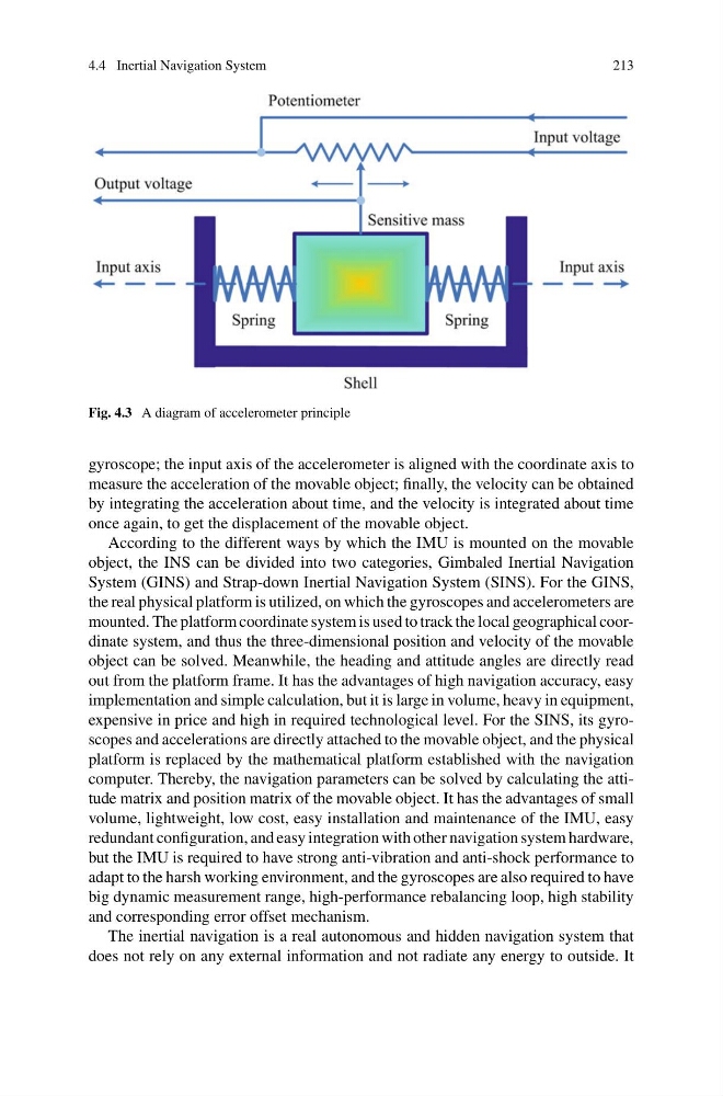
Fig. 4.3 A diagram of accelerometer principle
gyroscope; the input axis of the accelerometer is aligned with the coordinate axis to
measure the acceleration of the movable object; finally, the velocity can be obtained
by integrating the acceleration about time, and the velocity is integrated about time
once again, to get the displacement of the movable object.
According to the different ways by which the IMU is mounted on the movable
object, the INS can be divided into two categories, Gimbaled Inertial Navigation
System (GINS) and Strap-down Inertial Navigation System (SINS). For the GINS,
the real physical platform is utilized, on which the gyroscopes and accelerometers are
mounted. The platform coordinate system is used to track the local geographical coordinate system, and thus the three-dimensional position and velocity of the movable
object can be solved. Meanwhile, the heading and attitude angles are directly read
out from the platform frame. It has the advantages of high navigation accuracy, easy
implementation and simple calculation, but it is large in volume, heavy in equipment,
expensive in price and high in required technological level. For the SINS, its gyroscopes and accelerations are directly attached to the movable object, and the physical
platform is replaced by the mathematical platform established with the navigation
computer. Thereby, the navigation parameters can be solved by calculating the attitude matrix and position matrix of the movable object. It has the advantages of small
volume, lightweight, low cost, easy installation and maintenance of the IMU, easy
redundant configuration, and easy integration with other navigation system hardware,
but the IMU is required to have strong anti-vibration and anti-shock performance to
adapt to the harsh working environment, and the gyroscopes are also required to have
big dynamic measurement range, high-performance rebalancing loop, high stability
and corresponding error offset mechanism.
The inertial navigation is a real autonomous and hidden navigation system that
does not rely on any external information and not radiate any energy to outside. It
213
Fig. 4.3 A diagram of accelerometer principle
gyroscope; the input axis of the accelerometer is aligned with the coordinate axis to
measure the acceleration of the movable object; finally, the velocity can be obtained
by integrating the acceleration about time, and the velocity is integrated about time
once again, to get the displacement of the movable object.
According to the different ways by which the IMU is mounted on the movable
object, the INS can be divided into two categories, Gimbaled Inertial Navigation
System (GINS) and Strap-down Inertial Navigation System (SINS). For the GINS,
the real physical platform is utilized, on which the gyroscopes and accelerometers are
mounted. The platform coordinate system is used to track the local geographical coordinate system, and thus the three-dimensional position and velocity of the movable
object can be solved. Meanwhile, the heading and attitude angles are directly read
out from the platform frame. It has the advantages of high navigation accuracy, easy
implementation and simple calculation, but it is large in volume, heavy in equipment,
expensive in price and high in required technological level. For the SINS, its gyroscopes and accelerations are directly attached to the movable object, and the physical
platform is replaced by the mathematical platform established with the navigation
computer. Thereby, the navigation parameters can be solved by calculating the attitude matrix and position matrix of the movable object. It has the advantages of small
volume, lightweight, low cost, easy installation and maintenance of the IMU, easy
redundant configuration, and easy integration with other navigation system hardware,
but the IMU is required to have strong anti-vibration and anti-shock performance to
adapt to the harsh working environment, and the gyroscopes are also required to have
big dynamic measurement range, high-performance rebalancing loop, high stability
and corresponding error offset mechanism.
The inertial navigation is a real autonomous and hidden navigation system that
does not rely on any external information and not radiate any energy to outside. It