

206
4 Navigations from Ground to Space
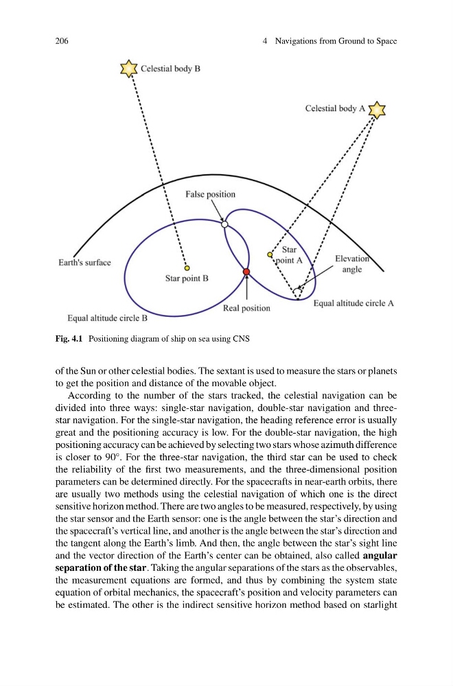
Fig. 4.1 Positioning diagram of ship on sea using CNS
of the Sun or other celestial bodies. The sextant is used to measure the stars or planets
to get the position and distance of the movable object.
According to the number of the stars tracked, the celestial navigation can be
divided into three ways: single-star navigation, double-star navigation and threestar navigation. For the single-star navigation, the heading reference error is usually
great and the positioning accuracy is low. For the double-star navigation, the high
positioning accuracy can be achieved by selecting two stars whose azimuth difference
is closer to 90°. For the three-star navigation, the third star can be used to check
the reliability of the first two measurements, and the three-dimensional position
parameters can be determined directly. For the spacecrafts in near-earth orbits, there
are usually two methods using the celestial navigation of which one is the direct
sensitive horizon method. There are two angles to be measured, respectively, by using
the star sensor and the Earth sensor: one is the angle between the star’s direction and
the spacecraft’s vertical line, and another is the angle between the star’s direction and
the tangent along the Earth’s limb. And then, the angle between the star’s sight line
and the vector direction of the Earth’s center can be obtained, also called angular
separation of the star. Taking the angular separations of the stars as the observables,
the measurement equations are formed, and thus by combining the system state
equation of orbital mechanics, the spacecraft’s position and velocity parameters can
be estimated. The other is the indirect sensitive horizon method based on starlight
4 Navigations from Ground to Space
Fig. 4.1 Positioning diagram of ship on sea using CNS
of the Sun or other celestial bodies. The sextant is used to measure the stars or planets
to get the position and distance of the movable object.
According to the number of the stars tracked, the celestial navigation can be
divided into three ways: single-star navigation, double-star navigation and threestar navigation. For the single-star navigation, the heading reference error is usually
great and the positioning accuracy is low. For the double-star navigation, the high
positioning accuracy can be achieved by selecting two stars whose azimuth difference
is closer to 90°. For the three-star navigation, the third star can be used to check
the reliability of the first two measurements, and the three-dimensional position
parameters can be determined directly. For the spacecrafts in near-earth orbits, there
are usually two methods using the celestial navigation of which one is the direct
sensitive horizon method. There are two angles to be measured, respectively, by using
the star sensor and the Earth sensor: one is the angle between the star’s direction and
the spacecraft’s vertical line, and another is the angle between the star’s direction and
the tangent along the Earth’s limb. And then, the angle between the star’s sight line
and the vector direction of the Earth’s center can be obtained, also called angular
separation of the star. Taking the angular separations of the stars as the observables,
the measurement equations are formed, and thus by combining the system state
equation of orbital mechanics, the spacecraft’s position and velocity parameters can
be estimated. The other is the indirect sensitive horizon method based on starlight