

Tarifa. Or in other words, any drifter able to reach this area (by, for instance, the
unlike processes associated with the coeval of strong atmospheric forcing and
suitable tidal conditions addressed previously in this chapter) increases its chances
to progress westwards and achieve successfully the unlike east-to-west interbasin
connectivity. The critical zone that would prevent such connectivity is the eastern
half of the Strait where the much narrower topography (topography again) enhances
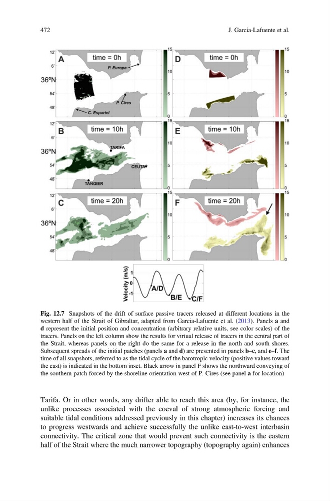
Fig. 12.7 Snapshots of the drift of surface passive tracers released at different locations in the
western half of the Strait of Gibraltar, adapted from Garcia-Lafuente et al. (2013). Panels a and
d represent the initial position and concentration (arbitrary relative units, see color scales) of the
tracers. Panels on the left column show the results for virtual release of tracers in the central part of
the Strait, whereas panels on the right do the same for a release in the north and south shores.
Subsequent spreads of the initial patches (panels a and d) are presented in panels b–c, and e–f. The
time of all snapshots, referred to as the tidal cycle of the barotropic velocity (positive values toward
the east) is indicated in the bottom inset. Black arrow in panel F shows the northward conveying of
the southern patch forced by the shoreline orientation west of P. Cires (see panel a for location)
472
J. Garcia-Lafuente et al.
unlike processes associated with the coeval of strong atmospheric forcing and
suitable tidal conditions addressed previously in this chapter) increases its chances
to progress westwards and achieve successfully the unlike east-to-west interbasin
connectivity. The critical zone that would prevent such connectivity is the eastern
half of the Strait where the much narrower topography (topography again) enhances
Fig. 12.7 Snapshots of the drift of surface passive tracers released at different locations in the
western half of the Strait of Gibraltar, adapted from Garcia-Lafuente et al. (2013). Panels a and
d represent the initial position and concentration (arbitrary relative units, see color scales) of the
tracers. Panels on the left column show the results for virtual release of tracers in the central part of
the Strait, whereas panels on the right do the same for a release in the north and south shores.
Subsequent spreads of the initial patches (panels a and d) are presented in panels b–c, and e–f. The
time of all snapshots, referred to as the tidal cycle of the barotropic velocity (positive values toward
the east) is indicated in the bottom inset. Black arrow in panel F shows the northward conveying of
the southern patch forced by the shoreline orientation west of P. Cires (see panel a for location)
472
J. Garcia-Lafuente et al.