

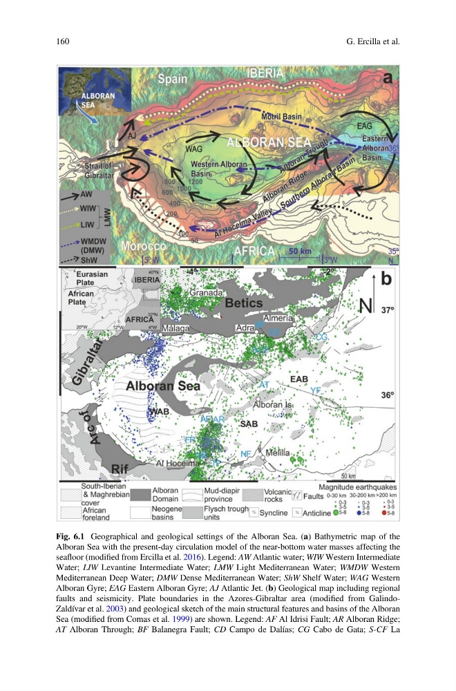
Fig. 6.1 Geographical and geological settings of the Alboran Sea. (a) Bathymetric map of the
Alboran Sea with the present-day circulation model of the near-bottom water masses affecting the
seafloor (modified from Ercilla et al. 2016). Legend: AW Atlantic water; WIW Western Intermediate
Water; LIW Levantine Intermediate Water; LMW Light Mediterranean Water; WMDW Western
Mediterranean Deep Water; DMW Dense Mediterranean Water; ShW Shelf Water; WAG Western
Alboran Gyre; EAG Eastern Alboran Gyre; AJ Atlantic Jet. (b) Geological map including regional
faults and seismicity. Plate boundaries in the Azores-Gibraltar area (modified from GalindoZaldívar et al. 2003) and geological sketch of the main structural features and basins of the Alboran
Sea (modified from Comas et al. 1999) are shown. Legend: AF Al Idrisi Fault; AR Alboran Ridge;
AT Alboran Through; BF Balanegra Fault; CD Campo de Dalías; CG Cabo de Gata; S-CF La
160
G. Ercilla et al.
Alboran Sea with the present-day circulation model of the near-bottom water masses affecting the
seafloor (modified from Ercilla et al. 2016). Legend: AW Atlantic water; WIW Western Intermediate
Water; LIW Levantine Intermediate Water; LMW Light Mediterranean Water; WMDW Western
Mediterranean Deep Water; DMW Dense Mediterranean Water; ShW Shelf Water; WAG Western
Alboran Gyre; EAG Eastern Alboran Gyre; AJ Atlantic Jet. (b) Geological map including regional
faults and seismicity. Plate boundaries in the Azores-Gibraltar area (modified from GalindoZaldívar et al. 2003) and geological sketch of the main structural features and basins of the Alboran
Sea (modified from Comas et al. 1999) are shown. Legend: AF Al Idrisi Fault; AR Alboran Ridge;
AT Alboran Through; BF Balanegra Fault; CD Campo de Dalías; CG Cabo de Gata; S-CF La
160
G. Ercilla et al.